Virginia
Deed and Land Records
Theoretically should be in order by county, then date
{NANCE in blue
with {original doc.} after is links to actual
documents}
If links don't work, you can find copies of originals
at the Library
of Virginia
Notes in green are my additions

AMELIA COUNTY
Page 518 John NANCE 142 new land ... unto John NANCE of Prince George County one certain tract or parcel of land containing 142 acres lying and being on the South side of Nottoway River in the County of Brunswick and bounded as followeth ... Beginning at the Indian Company's upper corner upon the River thence along their line South 31 East 122 poles to a corner hickory in the County line thence West 30 South 147 poles along the County line to a corner red oak thence North 30 West 74 poles to a corner black oak thence North 10 East 166 poles to a corner hickory upon the River below the mouth of a small run thence down Nottoway River as it meanders to the Beginning ... 7 Jul 1726
A list of all the surveys made in the county of Amelia from 10 day of Apr 1736 to the 10th day of June 1737 By Will Watson Surveyor
John Nance survey 22 Feb 1737
John Nance survey Nov 1738
VABB025.DOC Amelia Co Deed Book 1 Page 7- 9 Mathew SMART to John NANCE of Raleigh Parish 12 Nov 1735 £30 - 300 acres - on Ridge between branches of Little Nottoway River & Deep Creek Release: 13 Nov 1735 John NANCE to [Francis] EPPS 300 a 19 Jun 1741 [see VABB026]
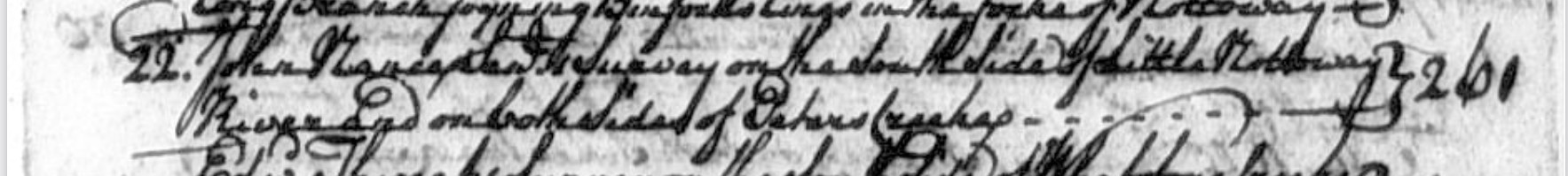
NANCE, John {Original Doc.}. Land grant 1 February 1738. Location: Amelia County. Description: 261 acres on the south side of Little Nottaway River, and on both sides of Peters Creek.
Source: Land Office Patents No. 18, 1738-1739, p. 197 (Reel 16).
VABB015.DOC Amelia Co VA Land Patents Book 18 Page 197 John NANCE 1 Feb 1738 261 acres - South side Little Nottoway River Both sides of Peters Creek
John & Jane NANCE to John Jr 261a 18 Jun 1741 [see VABB027]
NANCE, Rich {Original Doc.}. Land grant 12 September 1738. Location: Amelia County. Description: 400 acres in Amelia County, on the north side of the Horsepen Creek.
Source: Land Office Patents No. 18, 1738-1739, p. 104 (Reel 16).
VABB014.DOC Amelia Co VA Land Patents Book 18 Page 104-105 Richard NANCE 12 Sep 1738 400 acres - North side Horsepen Creek Fork of the Nottoway River, Reedy Branch Adj: Miles THWEAT, Samuel JORDAN, Richard NANCE to STAINBECK 400a 11 Dec 1750 [see VABB033] STAINBECK to John LEWIS 400a 2 Feb 1771 [see VABB050]
VABB017.DOC Amelia Co VA Land Patents Book 18 Page 404-405 Henry Roberson 22 Sep 1739 970 acres - Both sides of Little Nottoway River, Peters Creek, Lazaritta Creek, small Rockey Branch Adj: John Nance [see VABB015], Yarbrough, Hardaway
ELLIS, John {Original Doc.}. Land grant 22 September 1739. Location: Amelia County. Description: 400 acres on the south side of Little Nottaway, adjoing lines of John NANCE &c..
Source: Land Office Patents No. 18, 1738-1739, p. 468 (Reel 16).
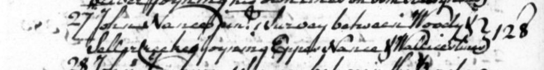
VABB026.DOC Amelia Co Deed Book 1 Page 308-309 John & Jane Nance to Francis Epps 19 Jun 1741 £60 - 300 acres - On Ridge between Branches of Little Nottoway River and Deep Creek Smart to John Nance 300a 12 Nov 1735 [see VABB025]
This Indenture made and were this amoned day of June in the Year of our Lord One Thousand Searon Sumbred and forty one John Nance of the County of Amelia Francis Eve . of the County of Prince George of the other part Wiknesell that the of said John Hance for the valluable consideration of Sixty Pounds him in hand paid the receipt whereof the said John Hawe doth hereby Acknowledge and the said Francis Spes therefrom and from every pouny thereof doth hereby acquit hath Bargain & Sole Along and Confirmed in and by these presents sold Bargain Sell alien & confirm Exes aforesaid & to his heirs for ever one Tract or pewill Land Lying in the County of Antha Three Hundred Bounded as ( viz ) Notary River P Troy Crook it being three hundred Nance of Matthew Smart of Martin Branton Parish in the County of Prine George H to have and to hold the aforesaid three hundred him the sd Francis Exes and to his heirs for ever with all Houses Gardens Orchards woods underwoods and all and Singular its appertenances & Apendances what Exor ℗ or and ⌨ in her bereaveprovember to the above ald Was have hereunto his hand and seal the day and ⌨ Signed Sealed & Acknowledged ⎬ John Expresence of us . ⎬ W Emerranson that Livery & Seizin of the within moutions land Crom Loos male and given unto the within mentioned francis poses to his heirs for ⌨ by the subscribed the Mance on the day and Year first within mentioned John F Nance ⌨ At a Court held for Amelia County 5th day of June 1740 Decd with the Memorandum of La very and Seven thereon Endorsed on presented in Court by John Hand ⌨ who acknow - = the sums als Jane the wife of the said Nance ( being first Sewanely ⌨ linquest her right of Dower of in and to the Land in the said Deed mentioned to Francis Exes the ffeoff which at His Notion is ordered to be Recorded . Last Samuell LINK
VABB027.DOC Amelia Co Deed Book 1 Page 310-312 John Nance Sr & Jane to John Nance Jr, 18 Jun 1741 £20 - 261 acres - South side Little Nottoway River & both sides Peters' Creek John Nance Patent 261 acres 1 Feb 1738 [see VABB015]
AMELIA COUNTY Deed Book 2 Page 171-172
Edward & Katy THWEATT to George DEVENPORT 6 Jul 1745
£20 - 400 acres - Both sides Horsepen Creek
Adj: Richard NANCE, Munford, Ellis, Flynn, Cock
VAPB 21:619 Patent to Edward THWEATT 25 Nov 1743
Rec: 19 Jul 1745 Page 171 This Indenture made the 6 Jul 1745 between Edward THWEATT of the County of Amelia of the one part and George DEVENPORT of the same county of the other part Witnesseth that the said Edward THWEATT for and in consideration of the sum of £20 current money of Virginia ... all that tract or parcel of land containing 400 acres lying on both sides the Horsepen Creek in the fork of Nottoway in the said County of Amelia bounded as follows: Beginning at Richard NANCE's corner black walnut on the North side the said Creek thence along his line North 16 East 20 poles to a corner thence West 28 North 304 poles to Ellis's line thence along his line South Page 172 36 West 40 poles to Munford's corner hicory thence along his line South 22 East 88 poles to his corner shrub white oak thence East 26 South 180 poles crossing the said Creek to a corner in a branch thence South 21 West 140 poles to Laulan FLYN'S line thence along his line East 17 South 263 poles to Cock's corner at the head of a branch and thence down the branch as it meanders to the Horsepen Creek thence up the Creek as it meanders to the Beginning ... Wit: None. Deed acknowledged by Edward & Katy THWEATT & ordered recorded on 19 Jul 1745, after Katy, his wife relinquished her right of dower.
AMELIA COUNTY Deed Book 2 Page 183
John Ellis Senr to Philip Pledger 18 Jul 1745
400 acres - his son-in-law - Nanny Ellis
Between Little Nottoway & Long Branch
Adj: [John] NANCE, Irby, Peters Creek This Indenture made the 18 Jul 1745 Between John ELLIS Senr of the Parish of Raleigh in the County of Amelia of the one part and Philip PLEDGER of the Parish and County aforesaid of the other part Witnesseth that the said John Ellis Senr for and in consideration of the love and affection he has for the said Philip PLEDGER for marrying his daughter Nanny ELLIS hath given ... a certain tract or parcel of land and plantation situate lying and being in the Parish and County aforesaid containing 400 acres and bounded as followeth to wit: Beginning at NANCE's corner hiccory on the River thence along his lines West 21 South 128 poles to his corner red oak thence North West 110 poles to his corner small white oak on Peters Creek thence South 304 poles to a corner pine thence South East 123 poles to a corner butterwood on the Long Branch thence down the Branch as it meanders to Irby's corner thence North 28 East 116 poles along Irby's line to his corner large white oak at the Head of a small Branch thence down the Branch as it meanders to the River thence up the River as it meanders to the Beginning ...
AMELIA COUNTY Deed Book 2 Page 342-344
Isham & Amy Eppes to Thomas Bowrey 10 Sep 1745
£200 - 1,993 acres - North side Little Nottoway River
Both sides main Seller fork of Deep Creek
Adj: John NANCE, Francis EPPES, Thomas CHAPPEL, John TAYLOR, John WILLIS, Anderson
Rec: 17 May 1746 Page 342 This Indenture made the 10 Sep 1745 between Isham EPES and Amy his wife of Bath Parish in Prince George County of the one part and Thomas Bowrey late of the Island of St. Christopher's of the other part Witnesseth that for and in consideration of the sum of £200 ... all that tract or parcel of land containing 1,993 acres lying and being in the County of Amelia on the North side of Little Nottoway River & on both sides main Sellar fork of Deep Creek adjoining Francis EPPES, Thomas CHAPPEL, John TAYLOR, John WILLIS, John NANCE & Anderson's lines & bounded as followeth (to wit) Beginning at TAYLOR's lower corner on Little Nottoway River thence along his line East 110 poles to his own old line thence along his own old line North 30 West 108 poles to his own old corner thence East 30 North 120 poles to TAYLOR's corner thence West 28 North 80 poles [sic 88 poles in Patent] along his line to a corner in the same thence North 31 East 198 poles to a faced corner thence Norrth 9 West 52 poles to Willice's line East 18 poles along his line to John NANCE's line thence along NANCE's line South 35 East 201 poles to his corner East 35 North 220 poles [sic 120 poles in Patent] to his corner thence North 14 East 7 poles to a faced corner thence East 12 South 24 poles to his own old corner thence along his own old lines of his Seller Survey East 20 South 120 poles to his own old corner thence South 20 West 38 poles to Frances EPPES corner thence along his lines East 20 South 54 poles to his corner thence North 14 East 240 poles to a corner in the Road thence East 15 South 120 poles to a faced corner near the Road thence S5E 120p to a corner pine thence S24W 368p to a corner pine thence West 13 South 94 poles to a faced corner thence West 13 North 154 poles to a faced corner thence South 25 West 68 poles crossing the Celler Creek to a faced corner thence West 62 poles to Chappel's line thence along his line North 15 West 34 poles to his own old line thence along the same West 30 South 172 poles to Chappel's corner thence along his lines South 15 East 200 poles to his corner thence South 25.5 West 100 poles to Chappel's corner of his new survey thence along his lines West 51 poles to his corner thence North 8 poles to his corner thence West 72 poles to Anderson's line thence along his lines North 109 poles to his corner poplar & gum thence West 15 South 180 poles to his corner Dutch Elm on Little Nottoway River & thence up the River as it meanders to the Beginning. 150 acres part thereof being granted to the said Isham EPPES by Letters Patent bearing date 3 Oct 1734;
[VAPB 15:345] 400 acres other part thereof being granted to the said Isham EPPES by Letters Patent bearing date 21 Nov 1734
[VAPB 15:364] and; 1,443 acres the residue being granted to the said Isham EPPES by Double Letters Patent bearing date 10 Jul 1745
[VAPB 22:252] ... Wit: John ORNSBY, George CURRIE, John DABNEY, Hugh MILLER. Deed acknowledged by Isham & Amy Eppes on 7 Jan 1745 & proved by oath of George Currie; proved by oath of John Ornsby on 21 Feb 1745 and proved by oath of Hugh Miller on 17 May 1746, and ordered recorded.
AMELIA COUNTY Deed Book 3 Page 287-288
John NANCE, Jr(*) & wife Martha (MAY) to Phillip PLEDGER 15 Sep 1749
65 acres - South side Little Nottoway River
Patent to John NANCE, Sr 261a 1 Feb 1738
John NANCE, Sr to Junior 261a 18 Jun 1741
PLEDGER to Michael HOLLAND 65a 27 Aug 1752 Page 287 This Indenture made the 15 Sep 1749 between John NANCE of the County of Amelia of the one part and Phillip PLEDGER of the said County of the other part Witnesseth that the said John NANCE for and in consideration of the sum of five shillings current money of VA to him ... a tract or parcel of land containing 65 acres situate lying and being in the County of Amelia aforesaid on the South side Little Nottoway River and bounded as followeth: Beginning at two hickorys on the said River bank thence South 69 West 128 poles to a red oak thence North 45 West 110 poles to a white oak on Peters Creek thence down the same as it meanders to a white oak thence North 10 East 8 poles to two small hickorys thence South 80 East 20 poles to pointers thence South 10 West 8 poles to a gum on the said Creek thence down the same to the Mouth thereof thence down the River above mentioned as it meanders to the first station John NANCE, Junr Page 288 Memorandum that on the 15 Sep 1749 possession & seisen of the within mentioned land and premises was had given and made by John NANCE to Philip PLEDGER according to Form? Effort? of the within Deed John NANCE Junr At a Court held for Amelia County the 20 Sep 1749 John NANCE, Junr presented and acknowledged this his Deed with the Livery of Seizen endorsed to Philip PLEDGER and ordered to be recorded Martha the wife of the said John NANCE being first privately examined and ? by assenting thereto relinquished her right of dower in the land conveyed by the said Deed.
(*Son of John NANCE II and Jane SMART)
AMELIA COUNTY Deed Book 3 Page 554-555
Richard NANCE (Prince Geo Co) to Littlebury Stainbeck 11 Dec 1750
70 lbs - 400 acres - North side Horsepen Creek Reedy Branch - In the fork of Nottoway River Adj: Miles Thweat, Samuel Jordan VAPB 18:104 Richard NANCE 400a 12 Sep 1738 Page 554 This Indenture made this 11 Dec 1750 between Richard NANCE of Prince George County and Littlebury STAINBACK of the same Witnesseth that for and in consideration of the sum of £70 ... 400 acres .. in the County of Amelia on the North side of Horsepen Creek in the fork of Nottoway River adjoining Miles THWEAT's and Samuel JORDAN's lines and bounded as follows to wit: Beginning at Thweat's corner butterwood on the side of the said Creek thence along his line North 16 East 190 poles to his corner red oak thence along Jordan's line North 11 East 38 poles to a corner in same thence West 12 North 278 poles to a faced corner thence South 16 West 231 poles to a small black walnut on Horsepen Creek aforesaid just below the Mouth of Reedy Branch thence down the said Creek as it meanders to the Beginning ... Page 555 [top part of page torn off]
John Dabney At a Court held for Amelia County 18 Jan 1750 this Deed from Richard NANCE to Littlebury Stainback was proved by the oaths of Peter Jones and William Firzgerald and at one other? Court held for the aforesaid county the 17 May 1751 it was also proved by the oath of John Dabney and ordered to be recorded.
VABB033.DOC Amelia Co Deed Book 3 Page 554-555 Richard Nance (Prince Geo Co) to Littlebury Stainbeck 11 Dec 1750 400 acres - North side Horsepen Creek, Reedy Branch In the fork of Nottoway River Adj: Miles Thweat, Samuel Jordan VAPB 18:104 Richard Nance 400a 12 Sep 1738 [see VABB014]
AMELIA COUNTY Deed Book 4 Page 436-438
Philip Pledger to Michael Holland 27 Aug 1752
865 acres - South side Little Nottoway River
Patent to John NANCE, Sr(*) 261a 1 Feb 1738 South side Little Nottoway River
John NANCE, Sr to Junior 261a 18 Jun 1741 South side Little Nottoway River
John NANCE, Jr(**) to Pledger 65a 15 Sep 1749 Page 436 This Indenture made the 27 Aug 1752 between Philip PLEDGER of the Parish of Nottoway and County of Amelia of the one part and Michael HOLLAND of Goochland County of the other part Witnesseth that the said Philip PLEDGER for and in consideration of the sum of £230 current money of Virginia ... one certain tract or parcel of land containing 865 acres situate lying and being in Nottoway Parish in the County of Amelia and in the Fork of Nottoway River 400 acres part of the above said tract formerly granted to John ELLIS by patent bearing date 22 Sep 1739 and by the said John ELLIS conveyed to the above Philip PLEDGER by deed 18 Jul 1745; 400 acres part of the above said tract formerly granted to Richard HUBARD by patent bearing date 1 Aug 1745 and from the said Richard HUBARD conveyed to the above Philip PLEDGER by deed 11 Sep 1750; also 65 acres part of the above said Tract being part of a Tract of 261 acres formerly granted to John NANCE Senior by Patent bearing date 1 Feb 1738 and from the said John NANCE Senior conveyed to John NANCE Junior by Deed bearing date 18 Jun 1741 and by the said John NANCE Junior conveyed to the above said Philip Pledger by Deed bearing date 15 Sep 1749; joining on the South side of Little Nottoway River and the lines of William Crenshaw, Peter Binford, John NANCE, Thomas Yarbrough, Samuel Smith ...
(*Wife Jane SMART, John was son of John NANCE I and Sarah SOLKINS)
(**Son of John NANCE II and Jane SMART)
AMELIA COUNTY Deed Book 4 Page 493
Thomas YARBROUGH to John YARBROUGH 8 Jan 1753
200 acres - South side Peters Creek
Adj: John NANCE, Hubbard, Ellis Page 493 This Indenture made this 8 Jan 1753 between Thomas YARBROUGH Senr of the Parish of Nottoway and County of Amelia of the one part and John YARBROUGH of the same Parish and County of the other part Witnesseth that the said Thomas YARBROUGH Senr for and in consideration of the sum of £500 current money of Virginia ... one certain tract or parcel of land containing 200 acres lying and being in the County of Amelia on the South side of Peters Creek and Bounded as followeth: Beginning at a corner shrub white oak thence South East 49 poles to Hubard line thence along his line East 17 North 146 poles to Ellis's line thence along his line North 234 poles to his corner white oak on Peters Creek thence up Peters Creek as it meanders to John NANCE's corner red oak thence by a dividing line to the beginning being part of a tract of 600 acres granted to the said Thomas YARBROUGH Senr by patent bearing date 20 Sep 1745 as also the reversions ...
AMELIA COUNTY Deed Book 5 Page 101-102
James NANCE, son of John NANCE of Nottoway Parish 24 Jan 1754
Apprentice 5 years to James Anderson Jr, joiner Page 101 This Indenture made this 24 Jan 1754 between John NANCE and James NANCE son of the said John NANCE of the Parish of Nottoway in the County of Amelia of the one part and James ANDERSON Junior Joiner of the same Parish and County of the other part. Witnesseth that the said John NANCE by virtue of these presents and with the advise and consent of his son James NANCE and with the consent and approbation of the Court of Amelia County doth bind his said son James NANCE to the said James ANDERSON Junior and with him after the manner of apprentice to live for and during the full time of five years from the 1 Dec last past; During all which time the said Apprentice his said Master faithfully shall serve his lawful commands every way? gladly obey; nor absent himself day or night from his said Master's service but in all things behave himself as a faithful apprentice ought to do during the full time for which he is bound and the said James ANDERSON ?? ?? himself the said James NANCE Page 102 to ?? be learned the art trade history and occupation of a carpenter and joiner which he the said Anderson now follows and intends so to do and find and provide for the said Apprentice good sufficient meat drink washing and lodging and clothes and at the end of the 5 years £3 current money and for the true performance and every the said ??? binds themselves to the other firmly by these presents for witness whereof we have hereunto set our Hands and seals the Day and year above written.
John NANCE
James NANCE
James ANDERSON
AMELIA COUNTY Deed Book 5 Page 342 John & Betty YARBROUGH to James MAY 28 Mar 1755 £37 - 200 acres - South side Peters Creek Part of 600a to Thomas YARBROUGH 20 Sep 1745
Adj: John NANCE, John YARBROUGH, Michael HOLLAND, Jeff WALLACE
May to Pain 300a 16 Oct 1756 This Indenture made this 28 Mar 1755 between John YARBROUGH & Betty his wife ... of the one part and James MAY ... of the other part Witnesseth that for and in consideration of the sum of £37/10 ... containing 200 acres ... in Nottoway Parish ... on the South side of Peters Creek ... being the lower part of 600 acres granted to Thomas YARBROUGH by patent bearing date 20 Sep 1745 ... adjoining John YARBROUGH, John NANCE, Michael HOLLAND, the side line of Jeff WALLACE ... Also McConnacughey Amelia County Deed Book 5 Abstracts page 45
AMELIA COUNTY Deed Book 5 Page 409 Dennis Burch to Thomas Walker 23 Jan 1756 167 acres - £49 - North side Horsepen Creek
Adj: [Richard] NANCE, Thweat, Thomas
Patent VAPB 28:321 Dennis Burch 12 Jan 1747 This Indenture made this 23 Jan 1756 Between Dennis BURCH and Licas his wife of the Parish of Nottoway in the County of Amelia of the one part and Thomas WALKER of the County and Parish aforesaid of the other part ... £49/10 current money of Virginia ... one certain tract or parcel of land containing 167 acres lying and being in the County of Amelia on the North side of Horsepen Creek in the Fork of Nottoway and bounded as followeth: Beginning at John THOMAS's corner in Edward THWEAT's line thence along Thweat's line East 28 South 264 poles to NANCE's line thence along his line North 16 East 211 poles to his corner thence West 15 South 300 poles along Thomas's line to the beginning it being granted to the said Dennis Burch by Patent bearing date 12 Jan 1747 ...
AMELIA COUNTY Deed Book 5 Page 430 James & Elizabeth MAY of Nottoway to John PAIN 16 Oct 1756 £30 - 300 acres - South side Peters Creek In the Fork of the Nottoway
Adj: John NANCE, Wallace, Pace, Smith, Binford, Michael Holland
Yarbrough to May 200a 28 Mar 1755 This Indenture made this 16 Oct 1756 between James MAY and Elizabeth his wife of the Parish of Nottoway in the County of Amelia of the one part and John Pain of Essex County & Parish of South Farnham of the other part Witnesseth that the said James and Elizabeth May for and in consideration of the sum of £30 current money of Virginia ... one piece or parcel of land containing 300 acres be the same more or less lying and being in Amelia County in the Fork of Nottoway on the South side of Peters Creek bounded as follows: Beginning at Jeff Wallace's corner hiccory on Peters Creek thence along his line to John Pace's corner thence along the line to Samuel Smith's thence along his line to Peter Binford's line thence along his line to Michael Holland's line thence along his line to Peters Creek to John NANCE's corner thence up the Creek as it meanders to the Beginning ...
VABB059.DOC Amelia Co Deed Book 7 Page 168 John White to Joseph White 13 Nov 1759 200 acres - Horsepen Creek Adj: Richard Nance [see VABB014], Lauglen Flynn, Cocke
AMELIA COUNTY Deed Book 7 Page 456-457
John NANCE(*) to {son} Giles NANCE 23 Apr 1761
£75 - 75 acres - North side Peters Creek
Part of Patent to John NANCE 261a 1 Feb 1738 This Indenture made the 23 Apr 1761, between John NANCE of Amelia County of the one part and Giles NANCE of the same County of the other part Witnesseth that the said John NANCE for and in consideration of the sum of £75 current money of Virginia ... one certain tract or parcel of land containing 75 acres be the same more or less situate lying and being in the County of Amelia on the North side of Peters Creek a small branch of Little Nottoway River, being part of a tract of 261 acres granted to John NANCE by Patent bearing date 1 Feb 1738 and bounded as followeth. Beginning at a new corner red oak upon Peters Creek thence up the Creek as it meanders to a corner red oak, thence North 2 West 140 poles to a corner black oak sapling, thence East 2 North 103 poles to a new corner red oak thence along a new line to the beginning upon Peters Creek ...
John NANCE
Wit: John Winn, Robert Stoker
Chas Irby, Thomas Yarbrough Memorandum That this day full and peaceable possession & Seizin of the within mentioned land and premises was given and delivered by the within named John NANCE to the within mentioned Giles NANCE. In presence of us: John Winn, Robert Stoker Chas Irby, Thomas Yarbrough At a Court held for Amelia County the 23 Apr 1761 This indenture and the memorandum endorsed were proved by the oaths of John Winn, Robert Staker and Charles Irby three of the witnesses thereto and ordered to be recorded.
(*Son of John NANCE II and Jane SMART)
AMELIA COUNTY Deed Book 7 Page 527
Thornton Pryor to Crispin Shelton 13 Nov 1761
100 acres - Fork of the Nottoway
Adj: Pryor, Bolling, Buford - Wit: John NANCE This Indenture made 13 Nov 1761 Between Thornton PRYOR of the County of Amelia of the one part and Chrispen SHELTON of the same County and Parish of Nottoway of the other part Witnesseth that the said Thornton PRYOR for and in consideration of the sum of £60 current money of Virginia ... one certain tract or parcel of land containing 100 acres be the same more or less Situate lying and being in Nottoway Parish in the County of Amelia and in the Fork of the Nottoway being part of a tract of land the said PRYOR purchased of John ELLIS Senr and being bounded as followeth (to wit) Beginning at a corner white oak on the said Crispin Shelton's line thence along a marked line to a corner hickory and red oak at the Main Road Thence along a marked line by the roadside to a corner red oak in Col Alexr BOLLING's line thence along his line to a corner hickory in Thomas Buford's and Bolling's line thence along the said Buford's line to the said Shelton's line thence along his line to the Corner white oak at the beginning ... Wit: Thomas Jeffres, Lewis Shelton, Thornton Pryor, James Buford, John NANCE
AMELIA COUNTY Deed Book 7 Page 642-643
John & Mildred Pain to Thomas Jones 25 Feb 1762
300 acres - South side of Peters Creek
Adj: John NANCE, Wallace, Pace, Smith, Peter Binford, Michael Holland,
Yarbrough to May 300a 28 Mar 1755
May to Pain 300a 16 Oct 1756 This Indenture made this 25 Feb 1762 between John Pain & Mildred his wife of the Parish of Nottoway in the County of Amelia of the one part and Thomas Jones of the aforesaid Parish & County of the other part Witnesseth that for and in consideration of the sum of £95 current money of Virginia ... one piece or parcel of land containing 300 acres be the same more or less; lying & being in Amelia County in the Fork of Nottoway on the South side of Peters Creek Bounded as followeth Beginning at Jeff Wallace's corner hiccory on Peters Creek thence along his line to John Pace's corner thence along his line to Samuel Smith's thence along his line to Peter Binford's line thence along his line to Michael Holland's line thence along his line to Peters Creek to John NANCE's corner thence up the Creek as meanders to Beginning ... Wit: Crispin Shelton, John Winn
AMELIA COUNTY Deed Book 7 Page 643-644
Michael Holland to John Winn 25 Mar 1762
32 acres - South side Nottoway River
Adj: John NANCE, Crenshaw, Michael Holland
John Winn & Col. Irby Page 643 This Indenture made this 25 Mar 1762 between Michael Holland of Amelia County of the one part & John Winn of the same County of the other part Witnesseth that the said Michael Holland for & in consideration fo the sum of £30 current money of Virginia ... one certain tract or parcel of land containing 32 acres be the same more or less situate lying & being in Amelia County on the south side of Little Nottoway River joining the Page 644 lands of Wm Crenshaw, Michael Holland, John NANCE the above said John Winn & Col Irby ...
AMELIA COUNTY Deed Book 8 Page 119-120
Peter Binford to Charles Irby 1 Apr 1763
400 acres - Between Long Branch and Whetstone Creek
Wit: John NANCE, Giles NANCE, etc
Patent to Binford VAPB 17:435 2 Jan 1737 Page 119 This Indenture made this 1 Apr 1763 Between Peter Binford of the County of Prince George of the one part and Charles Irby of Amelia County of the other part Witnesseth that the said Peter Binford for & in consideration of the sum of £150 current money of Virginia ... one certain tract or parcel of land containing 400 acres be the same more or less situate lying & being in Amelia County on the North side of Whetstone Creek in the Fork of Nottoway & bounded as followeth (to wit) Beginning at a white oak on the Long Branch thence South 34 West 96 poles to a corner red oak thence South 8 West 113 poles to a corner butterwood, in a small branch thence down the branch as it Page 120 meanders to Whetstone Creek thence down the said Creek as it meanders to a corner hickory thence North 23 East 32 poles to a faced corner, thence East 240 poles to a faced corner thence North 57 poles to a corner white oak on the Long Branch thence up the Long Branch as it meanders to the Beginning ... Wit: John NANCE, Nathan Fletcher, Wm Pace, Giles NANCE, Wm Crenshaw, John Winn
VABB044.DOC Amelia Co Deed Book 8 Page 119-120 Peter Binford to Charles Irby 1 Apr 1763 400 acres - Between Long Branch and Whetstone Creek Wit: John Nance, Giles Nance, etc Patent to Binford VAPB 17:435 2 Jan 1737
AMELIA COUNTY Deed Book 8 Page 314-316
John NANCE - statment regarding Michael HOLLAND 3 Jan 1764
and his gift of two Negros to HOLLAND's daughter Mary
John NANCE's children mentioned: Giles and Elizabeth Page 314 [ first half of page blank] about eight or nine years ago I heard my son Giles say that Michael HOLLAND had given his daughter Mary two Negros Patt & Nan. After that time I heard the said Michael HOLLAND say that he had given his daughter Mary the same two Negros Patt & Nan & sometime since the wife of the said HOLLAND was apprehensive that no Gift sho'd be good unless it was Recorded the said HOLLAND's Wife desired me to speak to her Brother Winn to have the above Gift recorded in Court. I spoke to the said Winn concerning that affair & he promised he would have it done. I told Mrs HOLLAND what Mr Winn said & she in my hearing asked her husband Michael HOLLAND if he was willing that Gift should be Recorded & he the said HOLLAND agreed to it in August or September in the year of 1762 but five weeks before the said Michael HOLLAND death he the said Michael HOLLAND come to my house & as we sat at Dinner in the yard, the the said Page 315 HOLLAND said what a fine thing it was to have a small Family, for his was so large that he wished that his children was old enough to go for themselves. I getting up from the Table, went into the House and as I step'd out again I heard my daughter Elizabeth say to the said Michael HOLLAND What you intend the Blacks shall go to the Whites yes said the said Michael HOLLAND I have given my daughter Mary two & I intend to give Joseph two & mentioned their names they being two Boys I said to Michael HOLLAND you dont divide them equally you should have given Mary a Girl & a Boy & Joe a Girl & a Boy, no said the said Michael HOLLAND Mary seemed to make choice of them two & them I have given her & them she shall have. 3 Jan 1764 John NANCE About five years ago I was at Michael HOLLAND's & there was some discourse between him & his Wife relative to a Gift of Two Negroes to his daughter Mary upon which he said he would give his daughter Mary Patt & Nan. 2 Jan 1764 Susanna Irby Some time in the year 1754 at the House of Michael HOLLAND's one night It happened in discourse between the Wife of the said Michael HOLLAND & myself concerning the Gift of two Negros named Patt & Nann, which she said her Husband had given to his daughter Mary before three witnesses the said Page 316 Michael HOLLAND made answer & said that he had given his daughter Mary them two negros & she should have them if she lived to age to enjoy them. 5 Jan 1764 Giles NANCE Sometime in June in the year 1762 at the House of Michael HOLLAND I heard the said Michael HOLLAND say he had given his daughter Mary two Negro Girls which he further saith was Patt & Nan I made answer & said I did not believe that Gift would stand good unless it was Recorded and the I had heard there was an Act to the Contrary Then the said HOLLAND's answer to me was that he had given his daughter Mary the above mentioned Two Negros before that act was made and he the said Michael HOLLAND further saith that his daughter Mary had a lawful Right to them Two Negros abovementioned, Clear from the claim or demand of any person & that she might take them away when she pleased & that should not be all that he would give her 5 Jan 1764 Wm Snead
AMELIA COUNTY Deed Book 8 Page 471-472
John White to William Cross 16 Oct 1764
200 acres - Both sides of the Horsepen Creek
Adj: John Lewis (formerly Richard NANCE)
Ellis, Williams Page 471 This Indenture made this 16 Oct 1764 Between John WHITE of the County of Amelia of the one part & William Cross of the said County of the other part Witnesseth that the said John White for and in consideration of the sum £75 current money of Virginia ... all that tract or parcel of land containing by estimation 200 acres be the same more or less lying & being in the County of Amelia on both sides of the Horsepen Creek in the Fork of Nottoway & bounded as follows Beginning at John Lewis corner black walnut the land that was formerly granted to Richard NANCE on the North side of the said Creek thence along his line 16 East [sic patent North 16 East] 20 poles to a corner thence West 78 North [sic patent West 28 North] 304 poles to Ellis's line thence along Page 472 his line South 36 West 40 poles to Williams corner hickory thence along his line South 22 East 88 poles to his corner shrub white oak thence East 26 South 108 poles crossing the said Creek to a corner hickory in a branch thence down the said branch as it meanders to the beginning
VABB046.DOC Amelia Co Deed Book 8 Page 471-472 John White to William Cross 16 Oct 1764 200 acres - Both sides of the Horsepen Creek Adj: John Lewis (formerly Richard Nance [see VABB014]) Ellis, Williams .
AMELIA COUNTY Deed Book 9 Page 57- 58
John & Martha NANCE to Charles IRBY 22 Oct 1766
60 acres - South side Little Nottoway - Peters Creek
Charles IRBY Will Land from John NANCE
Patent to John NANCE 261a 1 Feb 1738/9 Page 57 This Indenture made the 22 Oct 1766 between John NANCE of Amelia County of the one part & Charles IRBY of the same County of the other part Witnesseth that the said John NANCE for and in consideration of the sum of £60 Virginia currency to him paid ... one certain tract or parcel of land containing 60 acres be the same more or less Situate lying & being in Amelia County on the South side of Little Nottoway River. Beginning at a small Walnut above the Ford between John WINN's & the said NANCE's thence down the River as it meanders to the Mouth of Peters Creek thence up the Creek to a corner white oak from thence along a new line agreed upon & marked by the said Parties to the Bargain being a part of a Tract of 261 acres formerly granted to John NANCE Page 58 To have and to hold the said 60 acres of land with all the appurte NANCEs ... John NANCE Memorandum That this day full and peaceable possession & Seizen of the within mentioned land & premises was given & delivered by the within named John NANCE to the within mentioned Charles Irby. John NANCE At a Court held for Amelia County the 23 Oct 1766 This Indenture & the memorandum endorsed were acknowledged by the within named John NANCE party thereto & ordered to be recorded.
AMELIA COUNTY Deed Book 9 Page 105
Joseph Holland to Charles Irby 26 Feb 1767
118 acres - Peters Creek
Part John NANCE to Pledger 65a 15 Sep 1749
Pledger to Michael Holland 65a 27 Aug 1752 This Indenture made this 26 Feb 1767 between Joseph HOLLAND ... of the one part and Charles IRBY ... of the other part ... for and in consideration of the sum of £59 current money of Virginia one certain tract ot parcel of land containing 118 acres be the same more or less situate lying & being in the Parish and County aforesaid and in the fork of Nottoway it being part of the land & part if the plantation the said Joseph HOLLAND now live on & part of 65 acres conveyed from John NANCE to Philip PLEDGER by Deed bearing date the 15 Sep 1749 and bounded as followeth to wit, Beginnning at a corner white oak on the South side of Peters Creek thence South along Jones's line to a corner poplar on a small branch thence along a new marked line to a corner white oak on the Branch that goes down to the Mill Field thence down the said Branch as it meanders to a corner poplar thence along a new marked line to a corner on Winn's line thence on Winn's line to a corner white oak thence to a corner hiccory on Peters Creek thence up the said Creek as it meanders to the Beginning
AMELIA COUNTY Deed Book 10 Page 2- 4
John NANCE of Nottoway Parish to Giles NANCE 28 Oct 1767
£50 - 61 acres in Nottoway Parish, part of
Patent to John NANCE 261a 1 Feb 1738
Wit: David NANCE Page 52 This Indenture made this 28 Oct 1767 Between John NANCE of the Parish of Nottoway in the County of Amelia of the one part and Giles NANCE of the same Parish and County of the other part Witnesseth that the said John NANCE for and in consideration of the sum £50 current money of Virginia ... one certain tract or parcel of land containing 61 acres be the same more or less Situate lying and being in the Parish & County aforesaid and in the fork of Page 53 Nottoway it being part of a tract of 261 acres formerly granted to John NANCE by patent bearing date 1 Feb 1738 it being the land and plantation where the said John NANCE now lives and bounded as followeth to wit Beginning at Irby's corner white oak on Peters Creek thence up the said Creek as it meanders to a corner red oak in Peters Creek thence along a new line made between the said John NANCE and Giles NANCE to a corner red oak on Henry Robertson's line thence down the said line to a corner white oak on a small Branch thence down the said Branch as it meanders to Little Nottoway River thence down the said River as it meanders to a corner black walnut on Irby's line thence along the said line to the Beginning. ... John NANCE Wit: James Henderson, Charles Irby, David NANCE, Langston Bacon, Richard Robertson, James Robertson At a Court held for Amelia County the 20 Apr 1768 This Indenture and the memorandum endorsed were proved by the oaths of James Henderson and Charles Irby two of the Witnesses thereto and at another Court held for the said County the 28 Jul following the same was proved by the Oath of Langston Bacon another Witness & is ordered to be Recorded.
VABB049.DOC Amelia Co Deed Book 10 Page 2- 4 John Nance of Nottoway Parish to Giles Nance 28 Oct 1767 50 pounds - 61 acres in Nottoway Parish, part of Patent to John Nance 261a 1 Feb 1738 [see VABB015] Wit: David Nance
AMELIA COUNTY Deed Book 11 Page 304
Littlebury Stainbeck to John Lewis 2 Feb 1771
£100 - 400 acres - North side Horsepen Creek
Patent to Richard NANCE 400a 12 Sep 1738
Richard NANCE to Stainbeck 400a 11 Dec 1750
Adj: Thweatt, Jordan This Indenture made this 2 Feb 1771 between Littlebury Stainbeck and his wife of the County of Prince George and Parish of St Martin's of the one part and John Lewis of the County of Prince George and Parish of Bristol of the other part Witnesseth that for and in consideration of the sum of £100 current money of Virginia ... one certain tract or parcel of land lying and being on the North side Horsepen Creek in the Fork of Nottoway in the County of Amelia the said tract or parcel of land being the tract of land granted per patent bearing date 12 Sep 1738 to Richard NANCE for 400 acres ... Beginning at Thweatts corner butterwood on the North side of Horsepen Creek above mentioned thence along his line North 16 East 190 poles to his corner large red oak thence North 11 East 38 poles along Samuel Jordan's line to a corner in the same thence West 12 North 278 poles to a faced corner thence South 16 West 231 poles to a small black walnut on Horsepen Creek just below the Mouth of Reedy Branch and thence down the Creek to the beginning ...
VABB050.DOC Amelia Co Deed Stainbeck to John Lewis 400a 2 Feb 1771
AMELIA COUNTY Deed Book 7 Page 168
John White to Joseph White 13 Nov 1759
200 acres - Horsepen Creek
Adj: Richard NANCE, Lauglen Flynn, Cocke This Indenture made this 13 Nov 1759 between John White, joiner, of Amelia County in the Colony of Virginia of the one part and Joseph White of Amelia County aforesaid of the other part Witnesseth that the said John White for and in consideration of the sum of £30 ... a Tract or Parcel of Land containing 200 acres more or less and is situate lying & being in the County above said lying on one side of the Horsepen Creek in the Fork of Nottoway and is bounded as follows to wit: Beginning at Richard NANCE's corner black walnut on the North side of the said Creek thence along the said Creek to a branch thence up the Branch to a corner hickory thence S21W; 140p; to Laughlen Flyn's line thence along his line E17S; 263p; to Cocke's corner at the head of a branch as it meanders to the Horsepen Creek thence up the said Creek as it meanders to the Beginning ...
AMELIA COUNTY Deed Book 5 Page 403 -404
Robert & Mary Malone to Gideon Winfrie 15 Feb 1758
339 acres - On Winingham Creek
Adj: William Harris, Taylor, Fitzgerald - Part of:
Robert Malone Patent VAPB 18:127 439a 12 Sep 1738 Wit: Tanner, William Malone, {Sister} Mary (MALONE) NANCE
Rec: 28 Sep 1758
AMELIA COUNTY Deed Books 5 & 6 Page 95
G J McConnaughey
Mid-South Pub.Co c1981 Page 403 Robert Malone of Nottoway Parish to Gideon Winfrie. D. 15 Feb 1758. Consid: £170. 339 acres in Nottoway Parish adj. lines of William Harris on Winingham Creek, Taylor, Fitzgerrald, & the Creek as it meanders, being part of 439 acres pat. to sd. Malone on 12 Sep 1738. Wits: Joel Tanner, William Malone & Mary NANCE. Page 404 Possession obtained by Gideon Winfrie in presence of same wits. on 15 Feb 1758. Deed ackn. & ordered rec. 28 Sep 1758 after Mary, wife of Robert Malone, relinquished her right of dower.
NOTE: (from Nance Clearinghouse): It seems probable that the Mary who witnessed was the sister of Robert Malone (m. (1) Mary Harrison 1728, m.(2) Elizabeth Bridgeforth 1762), who m. Giles NANCE abt. 1754
AMELIA COUNTY Deed Book 7 Page 634-636
Thomas Whitworth to Samson Merideth 24 Jun 1762
222 acres - Upperside Namazeen Creek, Tuckers Branch
Adj: Cold Water Run, Drury Bolling, Thomas Clay
Wit: John NANCE and Giles NANCE
AMELIA COUNTY Deed Books 7 & 8 Page 69
G J McConnaughey
Mid-South Pub.Co c1981
Amelia Co - Deed - Book 7
Thomas Whitworth of Raleight Parish, Amelia Co., to Samson Merideth of same. D. 24 Jun 1762. Consid: £150.222 acres in Amelia Co. Upper side Namazeen Creek adj Thomas Clay, a meadow branch, Cold Water Run, Drury Bolling & Robert Tuckers branch as it meanders with all bldgs., etc. Wits: Alexander Erskine, John Winn, Alexander Gray, John NANCE & Giles NANCE. Possession obtained 24 Jun 1762.
AMELIA COUNTY Deed Book 7 Page 637-638
Robert & Mary Rowland of Amelia to John Beasely Jun 1762
240 acres - South side Lazaretta Creek
Adj: Long Branch, Church Ford, Bagley, Plunkett, Holt
Wit: John NANCE, Giles NANCE
AMELIA COUNTY - Deeds - Book 7
Page 635 Robert Rowland of Amelia to John Beasely. D. Jun 1762. Consid: £140. 240 acres in Amelia Co. on the South Side Lazaretta Creek Adj: Long Branch, the Church Ford, Bagley, Plunkett, Holt & a branch as it meanders to the Long Branch. Wits: Alexander Erskine, John Winn, Alexander Gray, John NANCE & Giles NANCE. [Mary, wife of Robert Rowland, relinquishment ]
AMELIA COUNTY Deed Book 11 Page 374-375
Joshua, Richard & Obadiah Hudson to Richard Wilson 17 Dec 1771
162 acres - Head Branch of Willingham Creek
Adj: Flat Rock Branch, Raccoon Branch
Wit: Giles NANCE
Rec: 23 Jan 1772
AMELIA COUNTY Deed Books 9 & 11 Page 91
G J McConnaughey
Mid-South Pub.Co c1981
Joshua Hudson, Richard Hudson and Obadiah Hudson of Amelia Co. to Richard Wilson of same. D 17 Dec 1771. Consid: £100. 162 acres in Amelia Co. on head branch of Willingham Creek, adj. Flat Rock Branch, and Raccoon Branch. Wit: John Winn, Richard Ward, Giles NANCE, Oliver Jeter, Moses Hudings and Alexander Gray. Recrded: 23 Jan 1772
AMELIA COUNTY Deed Book 14 Page 218-219
William Hudson of Amelia to James Henderson of Amelia 24 Nov 1777
193 acres - where Hudson now lives Adj: Charles Irby,
Richard Jones Jr, Wm Fitzgerald, Standleys Creek
Wit: Giles NANCE
AMELIA COUNTY Deed Books 12-14 Page 91
G J McConnaughey
Mid-South Pub.Co c1981 William Hudson of Amelia Co. to James Henderson of same. D. 24 Nov 1777. Consid: £250. 193 acres in Nottoway Parish, Amelia Co., where William Hudson now lives. adj. lines of Richard Jones Jr, William Fitzgerald, Standleys Creek, and line of Charles Irby. Wit: Thomas Wilkinson, William Watlington, Richard Ramsey, Gideon Winfrey, Giles NANCE. Rec: Order for recording not enetered, but Hudson acknowledged deed on 27 Nov 1777. Dower Relinguishment, Elizabeth Hudson, wife of William Hudson ... 29 Dec 1777 ...
AMELIA COUNTY Deed Book 14 Page 273-274
William & Jane Crenshaw to James Crenshaw 23 Feb 1778
330 acres - Fork of Nottoway south side Little Nottoway
Adj: Head of Turkey Branch, Holland, Long Branch,
Winn's mill pond, Robert Crenshaw
Wit: Giles NANCE, William Sneed, Charles Winfree
Wit: David Crenshaw
Rec: 26 Feb 1778
AMELIA COUNTY Deed Books 12-14 Page 97
G J McConnaughey
Mid-South Pub.Co c1981 William Crenshaw of Amelia to James Crenshaw of same. D. 23 Feb 1778. Consid: £1000. 300 acres in Amelia Co. in fork of Nottoway on south side of Little Nottoway, adj. head of Turkey Branch, line of Holland, the Long Branch, and Winn's mill pond, agreeable to a line made by deed d. 16 May 1767 between said Crenshaw and Robert, his son. Wit: Giles NANCE, William Sneed, Charles Winfree & David Crenshaw Pro: Giles NANCE, Charles Winfree & David Crenshaw on 26 Feb 1778. Rec: 26 Feb 1778 Relinquishment by Jane, wife of William Crenshaw 28 Feb 1778. Rec: 26 Mar 1778
AMELIA COUNTY Deed Book 15 Page 20
Thomas Jones of Pittsylvania to Richard Winn (Amelia) 1 Dec 1778
200 acres - Fork of Nottoway, South side Peters Creek
Adj: Wallace, William Sneed, Charles Irby,decd
Wit: Giles NANCE, Robert Bullington, etal
AMELIA COUNTY Deed Books 15 Page 7
G J McConnaughey
Mid-South Pub.Co c1981 Thomas Jones of Pittsylvania Co. to Richard Winn of Amelia Co. D. 1 Dec 1778. Consid: £600. 200 acres in Amelia Co. in Fork of Nottoway on south side Peters Creek, adj. lines of Wallace, William Sneed and line formerly that of Charles Irby, decd. Also he sells a copper still which said Jones previously purchased from James Henderson. Wit: John Winn, Giles NANCE, Luke Lipscomb, Robert Bullington, John Winn Jr, & Charles Winn. Rec: Date not entered, but consid. money pair 1 Dec 1778 in presence of same wit.
AMELIA COUNTY Deed Book 15 Page 30
Charles & Susannah Irby of Amelia to James Henderson 19 Dec 1778
460 acres - Adj: James Henderson, Richard Jones,
Fitzgerald, the road, the Glebe line
Wit: Giles NANCE et al
AMELIA COUNTY Deed Books 15 Page 8 G J McConnaughey Mid-South Pub.Co c1981 Charles & Susannah Irby of Amelia to James Henderson. D. 19 Dec 1778. Conside: £1509. 460 acres in Nottoway Parish, Amelia Co. Land is adj. lines of James Henderson opposite his house, Richard Jones, FitzGerrald, the road, and the Glebe line. Wit: Richard Jones Jr., William FitzGerrald, Francis FitzGerrald, Giles NANCE & Charles Ingram. Pro: Three of the witnesses on 23 Jan 1779 Rec: 23 Jan 1779
AMELIA COUNTY Deed Book 15 Page 280
Matthew Wallace to John Wallace 21 Apr 1780
200 acres - Adj: Little Nottoway, Stith Hardaway,
Charles Erskine, William Fitzgerald
Wit: Giles NANCE, et al
AMELIA COUNTY Deed Books 15-17 Page 37-38
G J McConnaughey
Mid-South Pub.Co c1981 Matthew Wallace of Amelia Co. to John Wallace of same. D. 21 Apr 1780. Consid: 15,000 pounds. 200 acres in Amelia Co. adj. Little Nottoway, and lines of Stith Hardaway, Charles Erskine, and William FitzGerrald. Wit: Christopher Dawson, John Irby, John Pettus & Giles NANCE Date not entered by consid. money paid on date of deed.
AMELIA COUNTY Deed Book 15 Page 281-282
John Wallace of Amelia to Matthew Wallace of Amelia 21 Apr 1780
15,000 pounds - 200 acres Adj: Christopher Dawson,
Giles NANCE, Henry Robertson, Joel Hundley, Thomas Overstreet, William Wood
Wit: Giles NANCE et al
AMELIA COUNTY Deed Books 15-17 Page 38
G J McConnaughey
Mid-South Pub.Co c1981 John Wallace of Amelia to Matthew Wallace of same. D. 21 Apr 1780. Consid: 15,000 pounds. 200 acres in Amelia Co. adj. lines of Christopher Dawson, Giles NANCE, Henry Robertson, Joel Hundley, Thomas Overstreet & William Wood. Wit: Christopher Dawson, John Irby, John Pettus & Giles NANCE. Rec: Date not entered, but possession obtained by Wallace on date of deed.
AMELIA COUNTY Deed Book 15 Page 281-282
Henry Bueford (Lunenburg) to William Blakely (Amelia) 11 Sep 1779
100 acres - Adj: Lamkin, Bolling, Blakley
Wit: William NANCE et al
AMELIA COUNTY Deed Books 15-17 Page 38
G J McConnaughey
Mid-South Pub.Co c1981 Henry Bueford of Lunenburg Co. to William Blakely of Amelia Co. D. 11 Sep 1779. Consid: 1,000 pounds. 100 acres in Amelia Co. adj. lines of Peter Lamkin, Stith Bolling & William Blakley. Wit: Peter Lamkin, Thomas Hightower, William NANCE, John Pettus & Medcap Thompson. Rec: Date not entered.
AMELIA COUNTY Deed Book 15 Page 364 John Crenshaw of Amelia to Nathan Jones of same 24 Aug 1780 200 acres - Head of Seller Creek, Epes, Johnnys Branch, Morgan Wit: Giles NANCE et al
AMELIA COUNTY Deed Books 15-17 Page 49 G J McConnaughey Mid-South Pub.Co c1981 John Crenshaw of Nottoway Parish, Amelia Co. to Nathan Jones of same county. D 24 Aug 1780. Consid: 3,000 pounds. 200 acres in Amelia Co., adj. head of Seller Creek, the Creek as it meanders, line of Epes, Johnny's Branch as it meanders and line of Morgan. Wit: Charles Connally, Giles NANCE & Thomas Eckels
AMELIA COUNTY Deed Book 15 Page 382 William Cross of Amelia to Thomas Jordan of Amelia 22 Jun 1780 200 acres - Both sides of Horsepen Creek Adj: John Lewis, formerly Richard NANCE, Ellis, Cross Rec: 26 Oct 1780
AMELIA COUNTY Deed Books 15-17 Page 51 G J McConnaughey Mid-South Pub.Co c1981 William Cross of Amelia Co. to Thomas Jordan of same. D. 22 Jun 1780. Consid: £150. 200 acres in Amelia Co. on both sides Horsepen Creek in the fork of Nottoway. Land is adj. line of John Lewis, formerly Richard NANCE, and lines of Ellis and said Cross. Wit: William Lewis, Samuel Jordan & Freeman Jordan Pro: Samuel Jordan & Freeman Jordan on 26 Oct 1790 (sic)
VABB072.DOC Amelia Co Deed Book 15 Page 382 William Cross of Amelia to Thomas Jordan of Amelia 22 Jun 1780 200 acres - Both sides of Horsepen Creek Adj: John Lewis, formerly Richard Nance, Ellis, Cross Rec: 26 Oct 1780
AMELIA COUNTY Deed Book 16 Page 101-103
Richard Winn (Prince Edward) to Thomas Ball of same 25 Jul 1782
200 acres - North side Lazaritta Creek, Little Nottoway
Adj: Francis Fitzgerald, James Henderson, Williamson
Also 1 acre South side Little Nottoway adj Crenshaws
Wit: James NANCE, Giles NANCE, William Brummar
AMELIA COUNTY Deed Books 15-17 Page 68-69
G J McConnaughey
Mid-South Pub.Co c1981 Richard Winn of Prince Edward Co. to Thomas Ball of same. Consid: 300,000 pounds paid by Thomas Ball, and for honor, love and affection which he [Richard Winn] bears for John, Charles and Susanna Winn. Thomas Ball bought from John Winn, Charles Winn and Susanna Winn 200 acres and a water grist mill situated in Amelia Co. on North side of Lazaritta Creek and Little Nottoway River, adj. land of Francis FitzGerrald, James Henderson & Lewelling Williamson, and a branch as it meanders to the mill pond, with one acre on South side of Little Nottoway River, adj. land of William & James Crenshaw. This deed assigns title to the 101 acres and the mill to Ball. Wit: William Brummar, James NANCE & Giles NANCE Pro: By three of wit. on 25 Jul 1782 Rec: 25 Jul 1782, after Ball obtained possession of land.
AMELIA COUNTY Deed Book 17 Page 365-366
William Crenshaw Sr to William Crenshaw Jr 10 Mar 1786
30 acres - On the South side Little Nottoway River
Adj: William Crenshaw Sr, Spring branch
Wit: Giles NANCE et al
AMELIA COUNTY Deed Books 15-17 Page 156
G J McConnaughey Mid-South Pub.Co c1981 William Crenshaw, Sr of Nottoway Parish, Amelia Co to William Crenshaw Jr. of same parish and county. D. 10 Mar 1786. Consid: £30. 30 acres in Amelia Co. on South side Little Nottoway River, adj. mouth of a spring branch, line of William Crenshaw Sr., the branch as it meanders, and the River as it meanders. Wit: Thomas Ball, Burrel Smith, David Crenshaw, James Crenshaw, Giles NANCE & John Dupuy. Pro: Thomas Ball, Burrel Smith & James Crenshaw on 27 Apr 1786. Rec: 27 Apr 1786 after possession obtained by Crenshaw, Jr on date of deed, and deed akn. by Crenshaw Sr.
AMELIA COUNTY Unrecorded Deeds by McConnaughey Page 27
Hall to Waugh Bill of Sale 3 Negroes 1 Oct 1792
Wit: Thomson V. Brooking & David NANCE Unrecorded Deeds & Other Documents, Page 27 Amelia Co. VA, 1750 1902 Gibson J. McConnaughey. (1994) Bill of Sale. Instance Hall of Chesterfield Co. to Andrew Waugh. D. 1 Oct 1792. Consid: £70. Hall sells his right in 3 Negroes - Phullis, Jack & Dilsey, with their future increase - conveyed to him by hill of sale d. 4 Jun 1792 from his brother, William Williams Hall, after the expiration of the year ninety-five. Wit: Thomson V. Brooking & David NANCE Pro: May 1793 by admrs.
AMELIA COUNTY Deed Book 3 Page 97
Samuel & Amy Flake to Richard Dennis 20 Nov 1749
200 acres - South side Main Seller Creek
Adj: George Maies or Man [Not NANCE as in the abstract]
Adj: John Clarke, Samuel Vaughn
Rec: 22 Aug 1751 [The hardcopy from the filming of this deed clearly has a Capital M (identical to that for "Current Money" a few lines earlier) where the abstractor chose the "N" for NANCE. The film is a bit dim for the letters following. My best guesses are either be "Mans" or "Maies." It ends with the letter "s." ]
AMELIA COUNTY, Virginia, Deed Books 3 & 4 Page 82
Abstracted and Compiled by Gibson Jefferson McConnaughey
Mid-South Pub Co c1981 Page 97 Samuel Flake & Amey his wife to Richard Dennis D. Nov 20 1749. Consid: £55. 200 acres S/S main Seller Creek, adj. lines of John Clarke, Samuel Vaughan & George NANCE, with all houses, etc. Wits: John Clarke, William Clarke & Henry Tinch
BEDFORD COUNTY
BEDFORD COUNTY Deed Book C-3 Page 398 Phillip BREWER to Nathaniel NANCE 27 Feb 1770 363 acres on Buffalo Creek
(Wife was Susannah GIBBS. Son of Richard NANCE and Mary LEONARD)
BEDFORD COUNTY Deed Book C-3 Page 401 Josiah COX (Cumberland) to Thomas NANCE (Dinwiddie) 27 Feb 1770 320 acres - Walton's Corner on Little Otter River Wit: Nath. NANCE, James Patterson
BEDFORD COUNTY Deed Book C-3 Several Deeds 27 Feb 1770 Witnesses: Nathaniel NANCE, Thomas NANCE Josiah COX (Cumberland) to Alexander GIBBS (Dinwiddie) 27 Feb 1770 Page 399 320 acres - Smith's corner on Little Otter Witness: Nath. NANCE, James Patterson,
Josiah Cox (Cumberland) to William Mead 27 Feb 1770 Page 403 160 acres - North side Little Otter River Wit: Nath. NANCE, James Patterson, Thomas NANCE
(Nathaniel's wife was Susannah GIBBS. Son of Richard NANCE and Mary LEONARD)
BEDFORD COUNTY Deed Book C-3 Page 442 William Callaway to Nathaniel NANCE 22 May 1770 610 acres on both sides of Elk Creek
(Wife was Susannah GIBBS. Son of Richard NANCE and Mary LEONARD)
BEDFORD COUNTY Deed Book C-3 Page 451 Nathaniel NANCE and wife Susanna to Nanny TURNER 22 May 1770 360 acres on Buffalo Creek
(Wife was Susannah GIBBS. Son of Richard NANCE and Mary LEONARD)
BEDFORD COUNTY Deed Book C-3 Page 461 Nathaniel NANCE to Alexander GIBBS 24 Jul 1770 206 acres on Elk Creek
(Wife was Susannah GIBBS. Son of Richard NANCE and Mary LEONARD)
BEDFORD COUNTY Deed Book C-3 Page 514 John Perrin to William Donald Trust deed 27 Nov 1770 Wit: Nath. NANCE, Fran Thorpe, Robert Donald
BEDFORD COUNTY -- Mar 1771 William NANCE bought from Nathaniel NANCE 200 acres on Elk Creek - Book 4 pg 21-22 Recorded 26 Mar 1771; no witnesses named
BEDFORD COUNTY Deed Book 5 Page 127-128 William NANCE (of North Carolina) to Cornelius NOELL 30 Jul 1773 £75 - 200 acres - Branch of Elk Creek Adj: small branch, Patent Line
Rec: 23 Aug 1773 Page 127 This Indenture made this 30 Jul 1773 Between William NANCE (of North Carolina) of the one part and Cornelius NOELL of Bedford County of the other part ... £75 ... parcel of land in Bedford County containing 200 acres on a branch of Elk Creek Beginning at an ash and maple on the said Branch thence off North 87 West 30 poles to pointers South 23 West 205 poles to Pattent Line thence on Pattent line East 82 poles to pointers South 30 East 72 poles to a red oak South 40 West 150 poles to two pines South 10 East 20 poles to a white oak in Pattent line thence off North 78 East 128 poles to an ash on a small branch thence down said Branch South 58 East 45 poles to the mouth of said Branch thence up the main Branch as it meanders to the beginning To Page 127 have ... Simon MILLER, Alexander GIBBS, William NANCE, Thomas NANCE, William GIBBS Memorandum That full and peaceable possession ... delivered by the within named William NANCE and [blank] his wife unto the within mentioned Cornelius NOELL ... 2 Aug 1773 ... At a Court ... 23 Aug 1773 ... ordered to be recorded.
BEDFORD COUNTY Deed Book 6 Page 407 Richard NANCE to his son Thomas NANCE 25 Mar 1780 £500 - 8 Slaves and Entire Estate
Rec: 27 Mar 1780 Page 407 Know all Men by these Presents that I Richard NANCE of Bedford County for divers good causes and valuable considerations to me moving but more especially for the Natural Love and affection I have and Bear to my Lawful Son Thomas NANCE and for the further consideration of the sum of £500 good and lawful money to me paid the receipt whereof is hereby acknowledged. Do give unto my said son Thomas NANCE and his Heirs forever the following slaves Viz Bobb, Jone, Bibb and Jack. Agg, Amey, Beck and Lidd, Together with all my estate real and personal of every kind or sort whatever and by these presents do warrant the Title of the aforesaid Estate from the Claim of me and my heirs and from the Claim or demand of any Person pretending to claim under me and from all Persons whatsoever, In witness whereof I have hereunto set my hand and seal this 25 Mar 1780. Signed Sealed & Delivered Richard NANCE (his mark) In the Presence of John Jarvis, Thomas Fuqua, Simmons Everitt, At a Court held for Bedford County 27 Mar 1780 This Bill of Sale was proved by the oaths of John JARVIS, Thomas FUQUA and Simmons EVERITT Witnesses thereto Subscribed and Ordered to be Recorded.
BEDFORD COUNTY Deed Book 7 Page 256 1780-1787 Thomas FUQUA to Thomas NANCE 22 day Sept 1783 for 14 pounds 28 acres of land situated in Bedford County and laying on the South Side of Otter River and bounded ... Witnesses Wm MOON, Alex GIBBS, Julius JONES proved 27 Oct 1783
BRUNSWICK COUNTY
Patents No. 12, 1724-1726, p. 518 (Reel 11).
HALL, Edmund {Original Doc}. Land grant 15 August 1737. Location: Brunswick County. Grantee(s): HALL, Edmund and NANCE, Daniel. Description: 385 acres on both sides of Jennoto Creek.
NANCE,
Daniel {Original Doc.}. Land grant 15 August 1737.
Location: Brunswick County. Grantee(s):
HALL, Edmund and NANCE, Daniel.
Description: 385 acres.
NANCE,
William. Land grant 1 June 1741. Location:
Brunswick County. Description: 129 acres
on both sides the south fork of Shining Creek..
Source: Land Office Patents
No. 19, 1739-1741, p. 974 (Reel 17).
BRUNSWICK COUNTY S. side Nottoway R., Brunswick Co. 1743 Wm. of Brunswick sells land pat. to Wm. 1741; wife Ann 1746 Aug. 26 -
BRUNSWICK COUNTY NANCE,
John. Land grant 28 August 1746. Location:
Brunswick County. Description: 400 acres on
both sides of Meherrin River. Source: Land Office
Patents
No. 24, 1745-1746, p. 398 (Reel 22).
Land Grant to John, 400 a.Brunswick Co., both
sides Meherrin River. Wm. had other patents
Brunswick Co VA Land Patents Book 24 Page 398
John NANCE 28 Aug 1746
40s - 400 acres - Both sides Meherrin River Owls Creek
John NANCE to George WELLS
200a 4 Sep 1751
John NANCE to Frederick NANCE 300a 22 Jan 1762
Page 398 40s - unto John NANCE
one certain tract or parcel of land containing 400 acres
lying and being in the County of Brunswick (sic) on both
sides of Meherrin River and bounded as followeth ...
Beginning at a hiccory on the said river thence South 50
West 24 poles to a red oak thence North 86 West 82 poles
to a white oak thence North 52 West 140 poles to a white
oak on Owls Creek thence up the said Creek as it meanders
to a white oak on the same thence North 45 East 120 poles
to a white oak thence South 80 East 110 poles to a white
walnut tree on the said River thence down the said River
to a white oak on the same thence South 53 Page 399 East
92 poles to a red oak thence South 25 East 108 poles to a
hiccory thence South 5 East 34 poles to a mulberry tree on
Meherrin River aforesaid thence up the meanders of the
same to the beginning ... 28 Aug 1746
VACC005.DOC Brunswick Co VA Land Patents
Book 24 Page 398 John NANCE
28 Aug 1746 40s - 400 acres - Both sides Meherrin River -
Owls Cr John to George WELLS 200a 4 Sep 1751 [see
VACC006] John NANCE to Frederick NANCE 300a
22 Jan 1762 [see VACC045]
BRUNSWICK COUNTY, Virginia Deed Book 3 (1744-1749) Pole for Drury STITH -- William NANCE, Deed Book 3, Page 513,
BRUNSWICK COUNTY John NANCE and Reuben NANCE sold land in Mecklenburg Dist., of Brunswick Co., 1771 and moved to Henry Co. 440 a. eastern section near Pittsylvania Co. line. Place called Leatherwood. Apr. 2, 1789 John NANCE and Reuben NANCE of Henry Co. to Jas. HIX of Brunswick Co.
BRUNSWICK COUNTY,
Virginia Deed Book 5 (1751-1755) Indenture made 28
December 1750, between Daniel NANCE
(of Surry County), and John BROWN (of Brunswick County),
£10, 244a, on Evanses Creek on both sides and bounded as
by Letters Patent granted to him the said Daniel NANCE dated 12 January
1746. Signed Daniell NANCE.
Wit: Thomas BRACEY, Josiah FLOYD (bhm), William NANCE (bhm). Court 26
March 1751, Indenture proved by the oaths of Thomas BRACY,
Josiah FLOYD and William NANCE.
Deed Book 5, Page 37.
BRUNSWICK COUNTY - VA Land Patents - Book 12 Page 518
John NANCE of Prince George Co 7 Jul 1726
142 acres - South side of Nottoway River
Indian Company's upper corner on river; on County line
[Surveyed for John NANCE 142a 17 Apr 1723 ]
BRUNSWICK COUNTY VA Land Patents Book 16 Page 383-384 Daniel NANCE & Edmund Hall 15 Aug 1737
385 acres - Both sides of Genito Creek; Source: Land Office Patents No. 17, 1735-1738, p. 383 (Reel 15).
Daniel NANCE to Thomas MALONE 230a 2 Oct 1749
Drury MALONE to Daniel NANCE 50a 2 Oct 1749
HALL to Thomas MALONE 185a 9 Apr 1750
Daniel NANCE to Drury MALONE 152a 7 Apr 1750 part of 385
Drury & Isham MALONE repatent 970a 5 Aug 1751 150 part of 385 820 new Thomas MALONE repatented 705a 12 May 1759 235 part of 385 470 new Page 383 Edmund HALL & Daniel NANCE - 385 acres ... Know ye that for the consideration hereinafter mentioned we have Page 384 given granted and confirmed ... do give grant and confirm unto Edmund HALL and Daniel NANCE one certain tract or parcel of land containing 385 acres lying and being in the County of Brunswick on both sides of Jenneto Creek and bounded as followeth to wit: Beginning on the Creek thence North 40 West 100 poles to a white oak then West 40 South 308 poles to a white oak on the Creek thence South 40 East 200 poles to a small white oak in a Valley thence East 40 North 308 poles to several trees chopt inwards and thence North 40 West 100 poles to the Beginning ... 15 Aug 1737
BRUNSWICK COUNTY VA Land Patents Book 19 Page 974-975 William NANCE 1 Jun 1741 15s - 129 acres - Both sides South Fork Shining Creek
NANCE to Ingram 129a 7 Jul 1743
Repatented by Ingram 12 Jan 1746 Page 974 William NANCE - 129 acres 15s ... unto William NANCE one certain tract or parcel of land containing 129 acres lying and being in the County of Brunswick on both sides the South fork of Shining Creek and bounded as followeth .to wit: Beginning at a butterwood thence North 21 East 124 poles to a red oak thence North 43 West 200 poles to a red oak thence West 43 South 74 poles to a white oak on the creek and thence down the creek as it meanders to the beginning ... Page 975 ... 1 Jun 1741 LINK TO DOCUMENT
BRUNSWICK COUNTY VA Land Patents Book 25 Page 239-241 William NANCE 12 Jan 1746 35s - 318 acres - South Side of Genito Creek
Adj: Josiah FLOYD [Thomas] ELDRIDGE Malone [to Malone], [John] JOHNSON
Source: Land Office Patents No. 25, 1745-1747, p. 239 (Reel 23).
John & Mary NANCE to Floyd 318a 15 Nov 1777 Page 239 ... 35s ... unto William NANCE one certain tract or parcel of land containing 318 acres lying and being in the County of Brunswick on the South Side of Jeneto Creek and bounded as followeth to wit: Beginning at Josiah FLOYD's corner white oak on Eldridge's
Page 240 line thence along his line South 33 West 68 poles to his corner white oak thence South 26 West 224 poles to his corner white oak on a Branch thence off South 7 West 80 poles to a white oak thence North 71 West 114 poles to a white oak thence North 15 West 160 poles to a blackjack thence North 16 East 70 poles to a white oak on MELONE's line thence along his line South 41 East 62 poles to his corner white oak thence North 50 East 318 poles to his corner hickory on Johnson's line thence along his line North 62 East 4 poles to FLOYD's corner hickory thence along his line South 3 East 154 poles to the beginning ... Page 241 ... 12 Jan 1746
BRUNSWICK COUNTY Daniel NANCE. Land grant 12 January 1746. Location: Brunswick County. Description: 244 acres on Avents Creek..
Source: Land Office Patents No. 25, 1745-1747, p. 569 (Reel 23).
VA Land Patents Book 25 Page 569-571 Daniel NANCE 12 Jan 1746
25s - 244 acres - Avents Creek
Daniel NANCE to BROWN 244a 28 Dec 1750
John BROWN - Henry MAYS 122a 23 May 1754 Page 569 Daniel NANCE - 244 25s ... unto Daniel NANCE one certain tract or parcel of land containing 244 acres lying and being in the County of Brunswick and bounded as followeth to wit: Beginning at a white oak on a branch thence North 2 East 148 poles to a hickory in Avents Creek thence down the said Creek as it meanders to a white oak on the Creek thence South 5 West 200 poles to a live oak thence South 44 East 114 poles to a red oak on a Branch thence down the said Branch as it meanders to the Beginning ... Page 570 ... [boilerplate] ... Page 571 ... 12 Jan 1746 ...
BRUNSWICK COUNTY NANCE, William. Land grant 12 January 1746. Location: Brunswick County. Description: 318 acres on the south side of Jeneto Creek..
VA Land Patents Book 28 Page 34- 35
John Ingram 12 Jan 1746
25s - 364 acres - Both sides Shining Creek
Adj: Owen Strange, John Stith
Residue never granted 235a repatented
William NANCE Patent 129a 1 Jun 1741
William NANCE to Ingram 129a 7 Jul 1743 Page 34 ... 25s ... unto John Ingram one certain tract ... containing 364 acres lying and being in the County of Brunswick on both sides of Shining Creek joining Owen Strange's line and bounded as followeth to wit: Beginning at his corner red oak on Shining Creek thence ... John Stith's line ... up the said creek as it meanders to the beginning. 129 acres part thereof being formerly granted unto William NANCE by our Letters Patent 1 Jun 1741 the right and title of which said land is since become vested in the said John Ingram and 235 acres the residue never before granted ... Page 35 ... 12 Jan 1746 ...
Lunenburg & BRUNSWICK COUNTY - VA Land Patents - Book 29 Page 480
Drury Malone & Isham Malone 5 Aug 1751
970 acres - Both sides Jeneto Creek
Adj: the Patent Line & William NANCE
820a never before granted
150a - Part of 385a Patent
Edmund Hall & Daniel NANCE 385a 15 Aug 1737
Daniel NANCE to Malone 152a 7 Apr 1750 Page 480 ... £4-5s ... unto Drury Melone and Isham Melone one certain tract or parcel of land containing 970 acres lying and being in the Counties of Lunenburgh and Brunswick on both sides of Jeneto Creek and bounded as followeth to wit Beginning where the Patent Line crosses the said Creek thence on the same South 40 East 100 poles to pointers thence South 50 West 308 poles to a white oak thence North 40 West 60 poles to William NANCE's corner red oak in the same thence on his Lines South 15 West 70 poles to pointers thence South 17 East 166 poles to a red oak thence new Lines North 68 West 322 poles to an ash in a small Branch of the Great Creek thence down the Branch as it meanders to the next Fork below thence up the other Branch 6 poles to a red oak on the same thence South 80 West 24 poles to a pine thence North 12 West 280 poles to a black gum thence North 60 East 258 poles to a white oak thence South 40 East 216 poles to a white oak in the Patent Line above mentioned thence along the same South 50 West 22 poles to a white oak on the Creek aforesaid and thence down the same as it meanders to the first station. 150 acres part thereof being Part of a Patent for 385 acres formerly granted unto Edmund Hall and Daniel NANCE bearing date 15 Aug 1737 and 820 acres the Residue never before granted ... Page 481 ... 5 Aug 1751 ...
BRUNSWICK COUNTY VA Land Patents Book 32 Page 24- 25 Daniel NANCE 5 Feb 1753 30s - 278 acres - Branches of Avents Creek Crosses Mecklenburg Co line Adj: [Edward] Winfield, Coles, road Thomas NANCE to Warren 273a 27 Nov 1780 VAEE059 Page 24 ... 30s ... unto Daniel NANCE one certain tract or parcel of land containing 278 acres lying and being in the County of Brunswick on the branches of Avents creek and bounded as followeth, to wit. Beginning at Winfield's corner white oak on Coles line thence along Coles line South 50 West 242 poles to a white oak on a Branch thence up the said Branch to a red oak on the same thence North 21 East 338 poles to a pine thence North 26 East 58 poles to Winfield's corner red oak thence along his line South 5 West 116 poles to his corner white oak on the Road thence South 49 East at 78 poles crossing the County line 171 poles to the Beginning ... Page 25 ... 5 Feb 1753
BRUNSWICK COUNTY VA Land Patents Book 27 Page 263-264 Benjamin Hawkins 25 Jul 1749 350 acres - South side Owls Creek and Both Sides of the Mouth of Little Owls Creek Hawkins to Barnaby Wells 350a 26 Nov 1750 Wells to Thompson ? Page 263 Beginning at a white oak on the said Creek thence South 51 West 76 poles to a white oak thence South 24 West 46 poles to a pine thence South 58 West 138 poles to a pine thence North 83 West 46 poles to an Elm on little Owls Creek thence up the said Creek as it meanders to a white oak on the same thence North 11 East 94 poles to a white oak thence North 30 East 256 poles to a white oak on the Creek thence down the said creek as it meanders to the beginning ...
BRUNSWICK COUNTY VA Land Patents Book 25 Page 574 Catlet Mann 12 Jan 1746 400 acres - Both sides Meherrin River Page 574 ... unto Catlet Mann ... 400 acres ... County of Brunswick on both sides of Meherrin River ... Beginning at Abraham Mishaux upper corner white oak on the River thence along his Page 575 lines East 52 poles to a turkey oak thence off North 2 East 102 poles to a pine thence North 50 West 82 poles to a pine thence South 53 West 216 poles to a white oak thence South 2 East 102 poles to a pine thence South 2 West 218 poles to a red oak thence South 50 East 58 poles to a white oak on the Hurricane Creek thence North 83 East 74 poles to a pine thence North 73 East 94 poles to a beech on Maherrin River thence up the said River as it meanders to the beginning ...
BRUNSWICK COUNTY VA Land Patents Book 32 Page 32 Benjamin Hawkins 5 Feb 1753 3776 acres - Both sides Juniper Creek Page 32 ... unto Benjamin Hawkins ... 3,776 acres ... in the County of Lunenburgh on both sides of Juniper Creek ... Beginning at Willinghams corner small ash on the said Juniper Creek thence along his line East 316 poles to a white oak thence off North 20 East 155 poles to a pine North 80 West 220 poles to pointers North 52 West 332 poles to a small Hiccory North 20 West 80 poles to a red oak North 70 West 234 poles to a pine West 93 poles to a pine North 55 West 394 poles to Waltons corner Black Jack thence along his lines South 80 poles to a pine South 40 West 320 poles to a pine South 48 East 6 poles to a red oak South 38 West 142 poles to a hiccory South 60 poles to a white oak South 62 West 52 poles to a hiccory South 31 East 118 poles to a gum thence new lines North 55 East 334 poles [to pointers thence South 30 ][from DeedMapper] Page 33 East 200 poles to a Gum South 65 East 360 poles to pointers South 190 poles to Roberts's corner red oak thence along his line the same course continued 90 poles to a white oak by Breedloves Creek thence down the said Creek as it meanders to Blackstones line thence along his line North 83 East 224 poles to his corner pointers in Breedloves line thence along his lines North 15 West 44 poles to pointers North 50 East 180 poles to a pine East 24 poles to a Hiccory by the said Juniper Creek and thence up the same as it meanders to the first station ... 5 Feb 1753
BRUNSWICK COUNTY VA Land Patents Book 30 Page 57 Timothy Murril & Richard Pruit [Prewit] 1 Jun 1750 465 acres - Both sides Hall's Creek Page 57 ... to Timothy Murril and Richard Prewit ... 465 acres ... in the County of Lunenburgh on both sides of Hall's Creek ... Beginning at Halls lower corner red oak thence new lines South 16 East 94 poles to a pines thence South 55 East 160 poles to two Hiccories thence North 60 East 160 poles crossing the Creek to a red oak thence North 14 West 398 poles to a pine in Halls line thence on his line South 30 West 318 poles crossing the Creek to the first station ... 1 Jun 1750 ...
BRUNSWICK COUNTY VA Land Patents Book 34 Page 90 John Willingham Junr 16 Aug 1756 400 acres - Both sides Liles's Creek Page 90 ... unto John Willingham Junr ... 400 acres ... in the County of Lunenburgh on both sides of Liles's Creek ... Beginning at a Beech on a Rock in the said Creek thence a new line North 10 West 10 poles to Williams's corner pine thence along his lines North 70 West 400 poles to a red oak South 30 West 160 poles to a pine thence a new line South 70 East 400 poles to a pine in Walkers line thence along his line North 30 East 64 poles to a Walnut on the said Creek and thence down the same as it meanders to the first station ... 16 Aug 1756 ...
BRUNSWICK COUNTY VA Land Patents Book 34 Page 113 Bryan Lester 16 Aug 1756 400 acres - Both sides Juniper Creek Page 90 ... unto Bryan Lester ... 400 acres ... County of Lunenburgh both sides of Juniper Creek ... Beginning at a Mulberry Tree on the Creek thence new lines West 50 poles to a Beech on the Creek thence up the same as it meandres to a Mulberry tree on the same thence off South 75 West 64 poles to a red oak North 79 West 132 poles to a white oak South 55 West 54 poles to a poplar on a Branch of the same thence down the said Branch as it meanders to the Creek thence up the Creek as it meanders to a red oak on the same thence off North 30 East 92 poles to a pine East 320 poles to a red oak South 45 East 106 poles to a red oak in Tandy Walker's line thence on his line South 18 West 32 poles to a white oak on the Creek aforesaid and thence down the same as it meanders to the first station ... 16 Aug 1756 ...
BRUNSWICK COUNTY VA Land Patents Book 28 Page 72 William Eavens [Evans] 25 Jun 1747 427 acres - Both sides South Fork, Meherrin River Page 72 ... unto William Eavens [Evans] ... 427 acres ... County of Brunswick on both sides of the South Fork of Maherrin River ... Beginning at a Spanish oak on the said River thence North 51 East 80 poles to a red oak thence North 31 West 140 poles to a maple on a Great Branch thence North 64 West 100 poles to a red oak thence South 73 West 134 poles to a red oak thence South 31 West 124 poles to a pine thence South 10 East 100 poles to a hiccory on a Branch thence South 86 East 40 poles to a pine thence South 44 East 84 poles to a white oak on a Branch thence North 85 East 62 poles to a white oak thence North 61 East 130 poles to a hiccory on the River thence up the said River as it meanders to the beginning ... 25 Jun 1747 ...
NANCE, Daniel. Land grant 5 February 1753. Location: Brunswick County. Description: 278 acres on the branches of Avents Creek.
Source: Land Office Patents No. 32, 1752-1756 (v.1 & 2 p.1-715), p. 24 (Reel 30).
BRUNSWICK COUNTY VA Land Patents Book 32 Page 628 Silvanus Walker 10 Sep 1755 400 acres - South side Meherrin River Page 628 ... unto Silvanus Walker ... 400 acres ... in the County of Lunenburgh on the South side of Meherrin River ... ... Beginning at Tandy Walker's corner elm on the Juniper Creek thence on his line South 57 West 30 poles to a white oak thence new lines South 5 East 42 poles to a red oak South 25 West 120 poles to a red oak South 10 East 120 poles to a red oak South 70 East 100 poles to a pine North 65 East 124 poles to a small red oak in Rivers's line thence on his line North 5 East 38 poles to a white oak North 80 East 68 poles to Meherrin River and thence up the watercourses as it meanders to the first station ...
BRUNSWICK COUNTY VA Land Patents Book 33 Page 72 Peter Rowlett 16 Aug 1756 825 acres - Both sides Meherrin River Page 72 ... unto Peter Rowlet ... 825 acres ... in the County of Lunenburgh on both sides of Meherrin River ... Beginning at Waltons corner ash on Gills Creek thence along his line South 5 West 110 poles to two red oaks thence a new line East 120 poles to pointers Page 73 in Walton's line thence along his line North 28 East 282 poles to his corner white oak thence a new line the same course continued 302 poles to a pine in Hall's line thence along his line North 40 West 26 poles to a pine thence along Coles's line South 77 West 160 poles to pointers in Cobbs line thence along his lines South 10 East 11 poles to a hiccory South 80 West 226 poles to Talbot's corner red oak thence along his line South 30 West 190 poles to a maple thence along Walton's lines South 50 East 190 poles to a hiccory South 70 East 6 poles to a pine South 20 West 18 poles to a white oak on Gills Creek aforesaid and thence up the same as it meanders to the first station ... 16 Aug 1756
BRUNSWICK COUNTY VA Land Patents Book 34 Page 166 George Walton 5 Feb 1757 4544 acres - Both sides Meherrin River 1240a being Part of a great Quantity granted Benjamin Hawkins 20 May 1749 - !1300a other Part granted John Hall 1 Jun 1750 vested in Walton - ! 2004a the Residue never before granted) Page 166 ... unto George Walton ... 4,544 acres ... County of Lunenburgh on both sides of Maherrin River ... Beginning at NANCE's corner Mulberry Tree on the said River thence along his line North 54 East 102 poles to a Spanish oak thence along Flin's lines North 5 West 108 poles to a red oak North 12 East 76 poles to a black jack South 50 East 414 poles to a red oak thence along Prewit's lines North 30 East 342 poles to a pine South 14 East 272 poles to Willingham's corner in the same thence along their line 280 poles tp their corner pine in Ingram's line thence along his lines North 14 West 72 poles to a white oak by a Branch of Swish Creek thence up the said Branch 6 poles to Staples's corner white oak thence along his line North 7 [West] 136 poles to his Corner Hiccory in Degraffenriedt's Line thence along his lines West 4 poles to a pine North 39 West 380 poles [only 200 poles in VPB 15:432] to a red oak North 194 poles to Moor's Corner pointers in the same thence along his line West 100 poles to a chesnut oak South 60 West 111 poles to Eelbank's corner red oak bush thence along his lines Page 167 South 45 East 120 poles to a white oak South 30 West 174 poles to a red oak North 60 West 24 poles to a red oak South 30 West 190 poles to a pine North 40 West 524 poles to an ash on a Branch of Springfield Creek South 70 West 210 poles to a pine thence along Rowlett's lines South 40 East 26 poles to a pine South 28 West 560 poles to pointers West 120 poles to two red oaks North 5 East 110 poles to an Ash on Gill's Creek thence down the said Creek as it meanders to Rowlet's corner white oak on the same still along his lines North 20 East 18 poles to pointers by a Meadow North 70 West 6 poles to a Hiccory North 50 West 190 poles to a Maple at a Spring thence along Boulden's line South 80 West 140 poles to Mitchels corner white oak in the same thence along his line South 10 West 180 poles to a poplar on Bear Branch thence along Petty's lines South 50 East 140 poles to a pine East 26 poles to pointers on Turkey Egg Branch South 10 West 170 poles to a pine thence along Rivers's lines South 60 East 168 poles to pointers South 28 West 6 poles to a red oak South 32 East 74 poles to a red oak thence along Mitchel's line being the Division line of Hawkins's Patent North 73 East 668 poles to NANCE's Corner white oak thence along his line North 27 West 54 poles to a Walnut Tree on the said Meherrin River and thence up the same as it meanders to the first station ... 5 Feb 1757
NANCE, Daniel. Land grant 20 August 1760. Location: Brunswick County. Description: 332 acres beginning &c., on Avents Creek.
Source: Land Office Patents No. 34, 1756-1765, p. 694 (Reel 33-34).
This Indenture made this 27th Day of November, 1780 BETWEEN Thomas NANCE and Anne his wife of the County of Brunswick of the one part and Sarah Warren and the Heirs of John Warren as it is mentioned on the back of this Indenture of the same County of the other part . . . that the said Thos. NANCE and Anne his wife for and in consideration of the sum of two thousand five hundred pounds . . . paid by the said Sarah Warren and the heirs of John Warren to be as it is mentioned on the back of this Indenture . . . doth grant bargain sell alien release and confirm unto the said Sarah Warren & heirs of John Warren to be as it is mentioned on the back of this Indenture and to their husband assigns forever, one certain Tract or parcel of Land containing two hundred and seventy three acres lying and being in the County of Brunswick and Meckingburg (sic) on the branch of Genito Creek that was granted unto Daniel NANCE of Brunswick County by letters Patent bearing date February the fifth day one thousand seven hundred and fifty three . . . Signed by Thomas NANCE (his mark) and Anne NANCE (her mark). WHEREAS John Warren by his last Will and Testament was desirous that his wife should have the use of his lands in the County during life or Widowhood for her to dispose of the same as she should think proper either to sell the same and purchase more or continue to keep the same by a clause in the said will left it in these words I Give her the use of all my Lands within this County to sell and dispose of as she shall think fit during her life or Widowhood, and provided that she should die or marry after selling the said Land before she purchases that immediately the money be put upon Interest and equally divided amongst my children when they arive (sic) to the age of eighteen Years and in case she should die or Marry in possession of the said Lands that then it be sold and divided amongst my sons (to wit) Merriott Warren, John Warren, William Warren, and Thomas Warren. ----- 1780 there Received of Thomas Merriott two thousand five hundred pounds it being the consideration money within mentioned by me. Signed by Thomas NANCE (his mark). At a Court held for Brunswick County the 27th Day of November 1780. This Indenture and Memorandum were Acknowledged by Thomas NANCE & Anne his wife parties thereto, she having been first privily examined as the Law direct, and the Receipt thereon endorsed was also Acknowledged by the said Thomas NANCE and together with the said Indenture and Memorandum, Ordered to be Recorded. Deed Book 14, page 80.
DEED BOOK 15 Know all men by these presents that I John SMITH, son of Salley or Sarah SMITH single woman of the County of Brunswick and State of Virginia for and in consideration of the sum of one hundred pounds . . . to me in hand paid by Jesse BREWER . . . doth grant bargain and sell and deliver unto the sd. Jesse BREWER one black mare bridle and saddle two feather beds and furniture eight setting chairs two iron potts and one dutch oven also all my right and title to a tract of land in Brunswick County Meherrin Parish on the Long Branch which land was left by James UPCHURCH deceased to the said John NANCE or SMITH son of Salley or Sarah SMITH and James SMITH in his Last Will and Testament which appears on record to him the said Jesse BREWER . . . in witness whereof the said John SMITH hath hereunto set his hand and seal this 25th Day of December 1790. Signed by John NANCE SMITH and witnessed by John Brewer, James Brewer, and Milly Dison (her mark). Brunswick County Court March 28th 1791. This Indenture of Bargain and Sale was acknowledged by John NANCE SMITH party thereto to be his act and deed and ordered to be recorded. Deed Book 15, page 51.
CHARLES CITY COUNTY LAND RECORD
***NOTE: Top of page missing on copy I have
Eaton NANCE, 75, 4/11?, 17.3.9?, 1, 5
John NANCE, 208?, 6 1/4, 65.17.11, 5
CHARLOTTE COUNTY
Blankinship from Roads This indenture, the 6th day of October, 1778, between Edward Roods, of Charlotte county, and John Blankinship of Lunenburg county, (conveys) for the sum of 13 pounds current money of Virginia, a certain tract of land containing 100 acres, formerly belonging to Jos. Williams, bounded, beginning at Kings Road on a pine on Atkins line, thence along his line to a corner red oak on ... thence north on George Wallon's line to a post oak, thence along his own line to a corner pine, thence along said Road's line to the first station
Signed: Edward Roads
Witness: Hood NANCE, Obediah NANCE, Asa Blankinship
CHARLOTTE COUNTY BK8 Pg187 04 Dec 1786 Neison Calvert sold to Levy Blankinship, both of Charlotte for five shillings, two negros, to wit; Ginna & Charles and 200a that Nelson lived on, his Black Smith Tools, a bed, Bay Mare, two cows & calves. Recorded 05 Feb 1787. Wit: John Blankenship, Hood NANCE, Mary Blankenship, and Mary Blankenship Sr
Char Co Bk 8 - Pg 223 21 Dec 1799
Blankinship to Stokes This indenture, the 21st day of December, 1799, between John Blankinship, of Halifax county, and Henry Stokes of Charlotte county, (conveys) for the sum of 50 pounds current money of Virginia, a certain tract of land on Reese's Fork, containing 100 acres, bounded, by the lines of Hood NANCE, Levy Blankinship, Joseph Duprey, John Lee, and George Walton's estate Signed: John (X) Blankinship Witness: Henry Haley, Levy Blankinship, Nelson Jennings, Rich'd Stone
CHARLOTTE COUNTY BK 11 Pg46 04 Sep 1807 Levi Blankenship sold to Campbell NANCE 15ac Head waters Reese Fork for 11 pounds. Wit Levi NANCE, Henry Haley and J. Tankersley
CHARLOTTE COUNTY Bk 12 Pg90, 23 Dec 1811 Levi Blankenship of Kentucky appointed Attorney William Dupree to sell to Woodward Haley 190ac on Kings Road Bounded by John Vaughn Campbell NANCE, Edward Lee, John Tankerlsley and Overton Pettus, for $350.00 Wit: Edward Lee, George Cole and Samuel Elam.
CHARLOTTE COUNTY Deed Book 1 Page 60-62
Thomas NANCE of Charlotte Co to John Haley 8 Jun 1765
£20 - 400 acres - Juniper Creek
Adj: Hawkins,
Adj: Walker
Rec: 8 Jun 1765 Thomas NANCE Patent 400a 15 Aug 1764
John Haley to Shorter 94a 4 Apr 1768
CHARLOTTE COUNTY Deed Book 1 Page 288-292
William NANCE of Charlotte Co to John Skelton 17 Sep 1766
£19/2/11 - 130 acres - Land where NANCE lived
In Charlotte Co - Both sides of Springfield Creek
Adj: Wilmoth, Walton, Moore, Davidson
Walton to John Wells 330a 3 Mar 1761
Wells to William NANCE 330a 7 Sep 1762 VACC046 Rec: 4 May 1767 [Note there are two successive pages labeled 288 Page 288 This Indenture made the 17 Sep 1766 Between William NANCE of Charlotte County of the one part and John Skelton of the County of Chesterfield of the other part Witnesseth that for and in consideration of the sum of £19/2/11 current money of Virginia to the said William NANCE in hand paid by the said John Skelton ...all that tract peice or parcel of land situated on both sides of Springfield Creek in the County of Charlotte containing 130 acres and bounded as follows to wit Beginning at a small hickory on the said Creek thence along Wilmoth's line South 50 West 140 poles to a pine thence along Waltons line South [Note there are two successive pages labeled 288 Page 288 40 East 87 poles to a white oak bush North 50 East 227 poles along Walton's and Davidson's lines to Moore's line North 50 West 87 [poles] to Wilmoth's corner pointers along Wilmoth's line a straight course to his corner white oak on the said Creek and thence down the same as it meanders to the first station being the land whereon the said NANCE lived & is part of a larger tract sold to John Wells by George Walton & conveyed by the said Wells to the said NANCE in the County Court of Lunenburgh and all houses buildings orchards ... their appurteNANCEs unto Page 289 [boilerplate] Page 290 heirs all and singular ... In witness whereof the said William NANCE hath hereunto Page 291 set his had and seal the day and year first above written William (W) NANCE Sealed and Delivered in the presence of Clement Read, Samuel White, Caleb Townes Mary Read Memorandum That quite and peaceable possession ... Partly from : Charlotte County, Virginia 1765-1771 Page 28 Deed Books 1 and 2 abstracted and compiled by Joanne Lovelace NANCE, Lapin Press, 1990 Charlottesville, VA Rec: 4 May 1767
CHARLOTTE COUNTY Deed Book 1 Page 272-273 Nathaniel NANCE of Bedford Co to Richard Foster 1 Jun 1767 £60 - No acres mentioned - In Charlotte Co Adj: Land Foster purchased from John NANCE & by lands of George Walton Rec: 1 Jun 1767 Richard NANCE Patent 210a 1 Jun 1750 Richard NANCE to Nathaniel 105a 21 Sep 1759
CHARLOTTE COUNTY Page 272 This Indenture made this 1 Jun 1767 Between Nathaniel NANCE (of the County of Bedford) of the one part and Richard FOSTER (of the County of Hanover) of the other part Witnesseth that the said Nathaniel NANCE for and in consideration of the sum of £60 current money of Virginia ... one certain tract or parcel of land situated lying and being in the County of Charlotte adjoining and bounded by the land which the said FOSTER formerly purchased of John NANCE together with and by the lands of George WALTON and to have and to hold ... with the appurtenances against him
Page 273 the said Nathaniel NANCE ... Nathaniel NANCE Signed Sealed & Delivered in presence of us [blank] Memorandum that on 1 Jun 1767 livery seizen of the with[in] mentioned land and premises was acknowledged to be made from the within named Nathan NANCE unto the within mentioned Richard FOSTER in presence of us whose names are under written Nathaniel NANCE At a Court held for Charlotte County 1 Jun 1767 The within written Indenture & the memorandum hereon Indorsed was acknowledged by the said Nathaniel NANCE and ordered to be recorded Teste Samuel Conn Clk
CHARLOTTE COUNTY Page 60 This Indenture made this 8 Jun 1765 Between Thomas NANCE (of the County of Charlotte) of the one part and John HALEY (of the County of Lunenburg and Parish of Cumberland) of the other part. Witnesseth that the said Thomas NANCE for ... £20 ... one certain tract or parcel of land situate lying and being in the County of Charlotte aforesaid and on the Juniper Creek containing 400 acres and bounded as follows Viz Beginning at Hawkins corner gum thence along his line South
CHARLOTTE COUNTY Page 61 65 East 162 poles to a white oak thence a new line South 18 West 154 poles to pointers in Walkers line thence along his line West 132 poles to a red oak thence a new line North 29 West 360 poles to pointers in HAWKINS line thence along his line North 55 East 138 poles to pointers; South 30 East 200 poles to the first station ... Thomas NANCE Signed and Sealed in presence of Jno Williams Jr Sherd Walton Ann Walton Memorandum that on 8 Jun 1765 ...
CHARLOTTE COUNTY Deed Book 1 Page 299-301
John Moore to son Joseph Moore 31 Jul 1767
529 acres Charlotte Co Branches of Meherrin
Adj: [William] NANCE, Washborn,
Wilmoth, Davis, Whitlock
Rec: 3 Aug 1767 Page 299 This Indenture made this 31 Jul 1767 Between John MOORE of the County of Charlotte of the one part and Joseph MOORE son of the said John MOORE of the same county of the other part Witnesseth that the said John MOORE for and in consideration of the natural love and affection that he bears to his son Joseph doth ... one certain tract ... in aforesaid County on the branches of Maherrin River containing by estimation 529 acres ... Beginning at my own corner in a thickett thence along my lines West 130 poles to a corner South 18 West 72 poles to a corner West 120 poles to [William] NANCE's line thence along his and Wilmoth's line North 42 West 160 poles to an oak in a branch South 70 West 30 poles to Davis's corner thence along his line North 5 West 96 poles to Whitlock's corner thence along his lines North 22.5 East 72 poles to a corner thence South 82 East 320 poles Page 300 to a white oak thence South 64 East 140 poles to a pine and thence along Washborn's line strait to the beginning ... Partly from : Charlotte County, Virginia 1765-1771
Page 29 Deed Books 1 and 2 abstracted and compiled by Joanne Lovelace NANCE, Lapin Press, 1990 Charlottesville, VA Signed: John Moore Wit: Wm Booker, Thos Flournoy, Thomas Stark Rec: 3 Aug 1767
CHARLOTTE COUNTY Deed Book 1 Page 313-315
Richard Burks to John Fisher 13 Jan 1768
South side of Springfield Creek
Rec: 1 Feb 1768 (deed of trust)
Lunenburg Co deed identical to this one
Richard NANCE to Burks 173 a 16 Dec 1767 ?
Burks to Tucker 173 a 13 Jan 1768 fragment Page 313 This Indenture made the 13 Jan 1768 Between Richard Burks of the County of Prince Edward of the one part and John Fisher of the County of Chesterfield merchant of the other part Witnesseth the Whereas the said Richard Burks is justly indebted to the said
CHARLOTTE COUNTY Page 313 John Fisher & Company in the sum of £524/4/3/3 current money of Virginia also to Duglass Hamilton the sum of £106/2/3 and to Messrs Robert Hastie & James Jameson, merchants in Glasgow, in the sum of £58/2/2 current money and the said Richard Burks being willing and desirous to pay & satisfy the said several Creditors their respective debts aforesaid with legal interest from this date He the said Richard Burks for & in consideration of the said several debts and for and in consideration of 5 shillings current money to him in hand paid before the ensealing and delivery hereof the receipt whereof he doth hereby acknowledge hath given granted bargained and delivered & confirmed and by these presents doth give grant bargain sell and deliver & confirm unto the said John Fisher his heirs & assigns for ever one certain tract peice or parcel of land situate lying and being in the County of Luneburgh containing by estimation 173 acres be the same more or less to the land conveyed to the said Richd
CHARLOTTE COUNTY Page 314 Burks by Richard NANCE by deed bearing date 16 Dec last past and is on the south side of Springfield Creek to the deed aforesaid is referred for greater certainty Also one other tract of land situate lying and being in Charlotte County containing 100 acres ...conveyed to the said Burks by Francis Clements ... deed recorded in Charlotte County Court reference being thereto had ... the place where the said Clements formerly kept an ordinary, Also the following slaves to wit, one Negroe woman named Nan purchased of the estate of Jno Phillips, one Negroe boy named Bob, one girl named Hannah, a boy named Cager a girl named Rachel a girl named Pegg & a girl named Cloe also nine geldings ... Page 315 and every advantage ... also 20 acres of land situate in Amelia County by the said Burks purchased of John James Dupee as by deed recorded in Amelia Court ... claims of all and every person or Page 316 persons whatsoever ... Page 317 the overplus shall be rendered to the said Richard Burks and in case the said effects shall fall short the said Richard Burks doth hereby engage to make up such deficiency ... Richard Burks Sealed & Delivered in presence of Miller Woodson P Carrington William Owen At a Court ... 1 Feb 1768 the within written deed of trust ...
CHARLOTTE COUNTY Deed Book 2 Page 217-220
Thomas Tabb to Frederick NANCE of Charlotte Co 25 May 1769
£25 - 100 acres - South side Meherrin,
Both sides of Owls Creek
Adj: Frederick NANCE, Williams,
Adj: Abner Wells, Foster
Rec: 4 Sep 1769 Page 217 This Indenture made 25 May 1769 between Thomas Tabb of Amelia County of the part and Frederick NANCE of the County of Charlotte of the other part Witnesseth ... sum of £25 current money of Virginia ... Page 218 Frederick NANCE and his heirs and assigns forever one certain tract or parcel of land situate lying and being in the County of Charlotte on the south side of Maherrin River and on both sides of Owl's Creek containing 100 acres be the same more or less and bounded as follows (viz) Beginning at the said NANCE's corner white oak on the said River thence along his lines South 72 West 40 poles to a small pine South 44 West 144 poles to pointers along Williams's line North 52 West 22 poles to Abner Wellses corner hickory thence along his lines North 2 West 66.5 poles to a white oak North 51 East 45 poles to a small hickory North 32 East 96 poles to a hickory bush thence along Foster's line South 80 East 38 poles to the River aforesaid and thence down the River as it meanders to the first station ... Page 219 ... [boilerplate] Page 220 ... Thomas Tabb Sealed and Delivered in Presence of William Jameson James Foster Josiah Foster, Wiott Garner ... 4 Sep 1769 ... ordered to be Recorded
CHARLOTTE COUNTY Deed Book 2 Page 225-227
Richard & Sarah Foster to Thomas Stark 3 Apr 1769
471 acres - in Charlotte Co
Nathl NANCE to Richd Foster 105a 21 Sep 1759
John Foster to Richard Foster
Richd NANCE to Richd Foster 105a 22 Sep 1759
Wm NANCE to James Foster 300a 15 Feb 1760
Adj: Robert Walton, West, and John Foster
Rec: 2 Oct 1769 Page 225 This Indenture made this 3 Apr 1769 Between Richard Foster and Sarah his wife of the Parish of Saint Paul in the County of Hanover of the one part and Thomas Stark of the Parish of Saint [blank] and County of Charlotte of the other part ... sum of £180 current money of Virginia ... 471 acres ... in County of Charlotte it being the land which the said Richard Foster purchased of one Nath[aniel] NANCE, John NANCE & John Foster and part of James Foster given by will to his son Richd Foster being part of the tract of land James Foster purchased of William NANCE and bounded on Robert Walton's line, West's line and John Foster's line, and also the Revertion and Revertions ... Page 226 from : Charlotte County, Virginia 1765-1771 Page 55 Deed Books 1 and 2 abstracted and compiled by Joanne Lovelace NANCE, Lapin Press, 1990 Charlottesville, VA Signed: Richard Foster Wit: Joseph Moore, William Simms, John Foster, Jarred McConnico Rec: 2 Oct 1769
CHARLOTTE COUNTY Deed Book 2 Page 462-464
John & Elizabeth Foster to Susannah Foster (widow) 1 Jul 1771
150 acres - In Charlotte Co - Owls Creek
Adj: Thomas Stark, Frederick NANCE
Adj: Abner Wells
Rec: 1 Jul 1771
Page 462 This Indenture this 1 Jul 1771 Between John Foster of the Parish of Cornwall & County of Charlotte of the one part and Susannah Foster of the Parish and County aforesaid widdow of the other part ... sum of £115 current money of Virginia ... in the County of Charlotte aforesaid ... 150 acres ... Beginning at the said John Foster's old corner on Owls Creek thence along Page 463 his line to Thomas Stark's line thence along Stark's line to the back lines of the old original survey thence along the said back line to a branch being the bounds of Frederick NANCE's land thence bind on the said Frederick NANCE to Abner Wells line and thence along the said Abner Wells lines to the first station is part of a larger tract granted to the said John Foster by James Foster by deed recorded in Charlotte Court bearing date 31 Dec 1770 and all houses, outhouses, ... Signed John Foster Rec: 1 Jul 1771 Right of dower relinguished by Elizabeth, wife of John Foster
CHARLOTTE COUNTY Deed Book 2 Page 467-468
John & Elizabeth Foster to Thomas Stark 1 Jul 1771
150 acres - William NANCE's Spring Branch
Land from Richard Foster 3 Apr 1769 and
Land to John Foster from his father
Adj: William NANCE, Hawkins
Rec: 1 Jul 1771 Page 467 This Indenture made this 1 Jul 1771 ... Between John Foster and Elizabeth his wife of the Parish of Cornwall & County of Charlotte of the one part & Thomas Stark of the Parish of Cornwall & County of Charlotte of the other part Witnesseth that ... sum of £80 current money of Virginia ... 150 acres in the Parish of Cornwall & County of Charlotte it being the land sold to me by Richard Foster a deed made by him 3 Apr 1769 and bounded as following viz. Beginning at a white oak standing on Walton's Road thence a new line to the head of William NANCE's Spring branch thence down the said branch to the River thence crossing the said River, thence a straight line to a red oak on Hawkins's line, it being the upper part of the land given to the said John Foster by his father and also the Reversion & Reversions ... Page 468 ... John Foster
Elizabeth Foster
... 1 Jul 1771 ... ordered to be recorded CHARLOTTE COUNTY Deed Book 3 Page 36- 38
William West to Thomas Chappel 9 Dec 1771
400 acres - Between Springfield Creek & Meherrin River
Patent to West 400 acres 10 Jul 1767
Adj: Richard NANCE, William NANCE,
Adj: Hawkins, Walton,
Adj: Prewet, Hall
Rec: 3 Feb 1772 Page 36 This Indenture made 9 Dec 1771 Between William West of the Parish of Nottoway and County of Southampton of the one part and Thomas Chappel Junr of the same Parish and County of the other part Witnesseth ... sum of £50 ... in the County of Charlotte containing by estimation Pge 37 400 acres more or less and bounded as followeth, to wit, Beginning at Richard NANCE's corner pointers thence along his line South 26 West 74 poles to William NANCEY's corner red oak in the same thence along his line South 45 East 110 poles to Hawkins corner hickory in the same thence along his line North 45 East 138 poles to Watson's corner pine, thence along his and Prewets line North 16 West 94 poles to a red oak thence along Hall's line North 50 West 410 poles to a black jack thence a new line South 12 West 92 poles to Watson's corner red oak thence along his line South 5 East 108 poles to Richard NANCEY's corner spanish oak thence along his line South 64 East 234 poles to the beginning this land lying between Springfield Creek and Meherrin River on the ridge as will appear by patent granted to the said William West bearing date 10 Jul 1767 ... from : Charlotte County, Virginia Deed, 1771-1777 Page 7 by TLC Genealogy, c1990 Miami Beach, FL . Signed William West. Wit: Charles Briggs, Richard Blow, William Murfee, Thos Read, P Carrington, Berry Green, Fran's Barnes Rec: 3 Feb 1772
CHARLOTTE COUNTY - Deeds - Book 3 Page 177-178
William & Frances NANCE of Charlotte Co & 7 Dec 1772
Thomas & Mary Wilmoth of Lunenburg to Robert Smelt
£75 - 200 acres - Both sides Springfield Creek
Adj: Haymeadow Branch, Moore & Davis' lines,
Rowlett, Collier, NANCE's division lines
Wit: John Willmutt, William Staples,
Wit: Jean NANCE (her mark)
Rec: 4 Jan 1773
Wells to William NANCE 330a 7 Sep 1762
William NANCE to Skelton 130a 17 Sep 1766 Page 177 This Indenture made this 7 Dec 1772 Between Thomas Willmoth of the County of Lunenburg & William NANCE of the County of Charlotte of the one part and Robert Smelt of the County of Charlotte of the other part Witnesseth that the said Thomas Willmoth and William NANCE for and and in consideration of the just and full sum of £75 current money of Virginia to them in hand paid ... one certain tract or parcel of land situate lying and being in the County of Charlotte on both sides of Springfield Creek containing 200 acres {be the same more or less) and bounded as follows (viz) Beginning at an ash on the Haymeadow Branch thence along Moore and Davis lines South 70 West 210 poles to a pine thence along Rowlett's lines South 40 East 26 poles to a pine, South 28 West 30 poles to pointers, thence along Collier's line South 40 East 147 poles to a pine thence along NANCE's division lines North 50 East 140 poles to the Creek aforesaid thence up the same as it meanders to NANCE's corner beech on the opposite side of the Creek thence still along NANCE's division line by a strait line of marked trees 86 poles to pointers in Moore's line thence along his lines North 40 West 109 poles to the first station together with all and singular ... unto the said Robert Smelt Page 178 to have hold use ... Thomas Willmuth William N NANCE ("N" his mark) Signed Sealed & Delivered in presnece of us John Willmutt, Wm Staples (his mark), Jean NANCE (her mark) At a Court held for Charlotte County on 4 Jan 1773 The above Indenture was acknowledged by the said Thomas Willmuth a party hereto to be his act & deed and Mary his wife also Frances NANCE wife of the said William NANCE they being first privately examined according to law severally relinquished their rights of dower in and to the lands & premises conveyed by their husbands in the said Indenture all which is ordered to be recorded. Teste: Thomas Reed
CHARLOTTE COUNTY Deed Book 3 Page 374-375
John Moore to Thomas Chappel 15 Dec 1772
910 acres - Both sides Springfield Creek, Long Branch
Adj: Phillips, Cole, William NANCE, Hall
Rec: 6 Dec 1773 Page 374 This Indenture made this 15 Dec 1772 Between John Moore of the County of Charlotte of the one part and Thomas Chappel of the County of Southampton ... £325 ... a certain tract or parcel of land containing 910 acres lying and being in the County of Charlotte on both sides of Springfield Creek and bounded as follows, viz, Beginning at a Pine on the road thence along Phillips's line North 25 East 80 poles to a red oak bush North 67 East 52 poles to a white oak near the said Creek North 30 East 144 poles to a pine North 30 West 74 poles to two oaks on the Road North 6 West 66 poles to pointers in Coles's line thence along the same South 60 East 13 poles to pointers North 30 East 174 poles to a white oak just on the long branch North 45 West 120 poles to a red oak South 60 West 80 poles to pointers West 134 poles to pointers South 18 West 74 poles to pointers West 124 poles to pointers in William NANCE's lines thence along his lines South 40 East 204 poles to pointers South 50 West 193 poles to pointers and thence along Hall's old line South 50 East 312 poles to the first station ... Page 375
CHARLOTTE COUNTY, Virginia Deed, 1771-1777 Page 41 by TLC Genealogy, c1990 Miami Beach, FL Signed John Moore Wit: Thomas Stark, Joseph May, Cornelius Collier, Joseph Moore Rec: 6 Dec 1773
CHARLOTTE COUNTY Deeds Book 3 Page 178-179 John & Lucy Moore Jr to Thomas Chappel 4 Jan 1773 235 acres - Both sides Springfield Creek Adj: Wells now [Wm] NANCE), Collier, Coles Rec: 4 Jan 1773 Page 178 This Indenture made this 4 Jan 1773 Between John Moore Junr and Lucy his wife of the County of Prince Edward of the one part and Thomas Chappell of the County of Southampton of the other part Witnesseth ... the sum of £75 current money of Virginia ... a certain tract ... in the County of Charlotte ... 235 acres of land ... on both sides of Springfield Creek ... Beginning at Wells's corner white oak, now NANCEs, then along his line South 50 West 202 poles to Colliers linhe, then along the same South 40 East 124 poles to a red oak , South 50 East 64 poles to pointers, thence a new line / now Moores/ North 50 East 193 poles to pointers and thence along Coles line North 40 West 188 poles to first station ... Page 179 ... John Moore
Lucy Moore Signed Sealed & Delivered in the Presence of us Nathaniel Venable, And. Mackenzie, Lewelling Williamson ... 4 Jan 1773 ... ordered to be recorded ...
CHARLOTTE COUNTY Deed Book 3 Page 333-335
Alexander Womack to David Rice 2 Aug 1773
400 acres - Head branches of Owls Creek
Adj: Mitchell, Hawkins, Williams,
Adj: [John Jr] NANCE
Patent to Zachery 400a 10 Aug 1758
Zachery to Womack 400a
Rec: 2 Aug 1773 Page 333 This Indenture made this 2 Aug 1773 Between Alexander Womack of the Parish of St Patrick in the County of Prince Edward of the one part and David Rice ... Page 334 consideration of the sum of £50 ... a certain tract ... in the County of Charlotte on the head branches of Owls Creek containing 400 acres ... Beginning at Mitchell's corner red oak thence a new line South 40 West 130 poles to pointers in Hawkins's line thence along his lines South 70 East 48 poles to a red oak South 20 East 80 poles to a small hickory South 52 East 268 poles to Williams's corner small hickory in the same thence along his lines North 14 poles to NANCE's corner small hickory thence along his line the same course continued 348 poles to a small white oak in Mitchell's line and thence along his line West 198 poles to the first station it being a parcel of land which was granted to the said Alexander Womack by a deed from Bartholomew Zackery duly recorded in the County Court of Lunenburg ... Alexander Womack from : Charlotte County, Virginia Deed, 1771-1777 Page 35 by TLC Genealogy, c1990 Miami Beach, FL Martha, the wife of said Womack, relinquished her right to dower Rec: 2 Aug 1773
CHARLOTTE COUNTY Deed Book 3 Page 418-419
Robert Smelt to Thomas 13 May 1774
25 acres - Adj: Collier, Willmoth
Wit: William NANCE, John Watkins, John Breedlove
Rec: 4 Jul 1774 Page 418 This Indenture made this 13 May 1774 Between Robert Smelt of the County of Charlotte and Parish of Cornwall of the one part and Thomas Davis of the County of Prince Edward of the other part Witnesseth ... £5 ... a certain tract ... in the County of Charlotte ... 25 acres ... Beginning at a pine North 70 East 66 poles to a black jack South 20 East 66 poles to a pine South 79 West 90 poles to a corner red oak saplin in Collier's line thence North 40 West 8 poles to pointers in Wilmoth's line North 28 East 30 poles to a pine North 40 West 26 poles to the beginning ... Page 419 from : Charlotte County, Virginia Deed, 1771-1777 Page 51 by TLC Genealogy, c1990 Miami Beach, FL Signed: Robert Smelt. Wit: Tho Read, Sam Comer, John Washburne, Wm NANCE, John Watkins, John Breedlove. Sarah, the wife of the said Smelt, relinquished her right of dower. Rec: 4 Jul 1774
CHARLOTTE COUNTY Deed Book 1 Page 372-374
John Hunt to Thomas Norris 10 Oct 1767
100 acres - Charlotte Co on High Gate Run
Wit: William Norris, Thomas NANCE, William Brown
Rec: 1 Feb 1768
Part of John Hunt Patent 404a 5 Jun 1765 Page 372 This Indenture made this 10 Oct 1767 Between John Hunt of the County of Charlotte of the one part and Thomas Norris of the County of Lunenburg of the other part Witneseth ... £[blank] ... assigns forever Page 373 one certain tract ... in the County of Charlotte on High Gate Run containing 100 acres being part of a larger tract granted to Joseph Hunt for 404 acres by patent bearing date 5 Jun 1765 and bounded as followeth (viz) Beginning at Brown's corner black jack thence along Evins's line North 54 West 68 poles to a red oak North 40 West 28 poles to a white oak thence North 31 East 136 poles to Norris's corner pine thence along his line South 32 East 196 poles to a maple on a corner in Brown's line and thence along Brown's line South 82 West 100 poles to the beginning ... Page 374 his Seal the day and year above written John Hunt Signed Sealed and delivered in presence of William Norris Thomas NANCE William Brown ... At a Court held for Charlotte County 1 Feb 1768 ... by the oaths of all the witnesses hereto subscribed & ordered to be recorded.
CHARLOTTE COUNTY Deed Book 1 Page 453-454
John Haley (Hailey) to James Shorter 4 Apr 1768
94 acres - in Charlotte Co on branches of Juniper Creek
Adj: Breedlove, Robards, Walton, and Pigg Path
Rec: 6 Jun 1768
Thomas NANCE to Haley 400a 8 Jun 1765 VACC049 Page 453 This Indenture made this 4 Apr 1768 Between John Hailey of the County of Lunenburg of the one part and James Shorter of the County of Charlotte of the other part Witnesseth ... £5 ... a certain tract ... in the County of Charlotte aforesaid and on the Branches of Juniper Creek being part of a larger tract granted to the said Haley by a deed of conveyance from Thomas NANCE contained 94 acres and bounded as follow viz Beginning at a pine in Breadlove's line on the Ridge Path thence along his line South 30 East 116 poles to Robards's corner red oak thence along his line North 88 East 144 poles to pointers thence along Walton's line North 18 East 58 poles to a hickory bush and pointers on the Ridge Path aforesaid and thence up the said Path as it meanders to the first station ... Page 454 the day and year above written John Haley Signed & Sealed in Presents of Charles Sullivant Robt Breedlove, Kindress Shorter ... 4 Apr 1768 ... said Jno Haley & Mary his wife ... ordered to be recorded ...
CHARLOTTE COUNTY Deed Book 2 Page 436 William Davidson to John Moore Junr 2 Mar 1771 Adj: William NANCE & John Moore Junr Page 436 This Indenture made this 2 Mar 1771 Between William Davison of the County of Prince Edward of the one part and John Moor Junr of the same County of the other part Witnesseth ... £28 current money of Virginia ... one certain tract or parcel of land situate lying and being in the County of Charlotte on Spring Creek adjoining the lands of John Moore Junr and William NANCE ... Beginning at Wells's line thence South 50 West 202 poles to pointers thence South 40 East 124 poles to a red oak thence South 50 East 64 poles to pointers thence North 50 East 193 poles to pointers thence North 40 West 188 poles to the beginning ...
CHARLOTTE COUNTY Deed Book 3 Page 30- 31
Benajah Thompson to Christopher McConnico 7 May 1770
169 acres - In Charlotte Co & Lunenburg Co
Both sides Springfield Creek
Adj: [William] NANCE's old line, Mill pond,
Adj: Richard Pewitt, Burk, Hawkins, Foster, Roberts
Rec: 2 Dec 1771 Partly from : Charlotte County, Virginia Deed, 1771-1777 Page 6 by TLC Genealogy, c1990 Miami Beach, FL From Benajah Thompson of Cumberland County to Christopher McConnico of Lunenburg County, for £100, a certain tract of land in the counties of Lunenburg and Charlotte on both sides of the Springfield Creek containing about 169 acres Beginning at a white oak by the side of the old mill pond thence South 70 East 36 poles on Richard Pewitts line to a red oak, South 26 East 56 poles to a black walnut tree on Springfield Creek thence down the Creek and a gut to a Spanish oak bush thence South 20 East 38 poles to a red oak thence South 60 West 17 poles along Burk's line to the Springfield Creek thence down the Creek to a corner ash thence North 79 West 102 poles NANCE's old lines to pointers thence South 15 West 48 poles NANCE's old lines to a Spanish oak bush, thence South 80 West 79 poles along Hawkins' line to a red oak bush thence North 45 West 70 poles Foster's line to a hickory thence North 45 East 138 poles along Roberts line to a pine thence North 16 West 43 poles to a white oak; thence North 57 East 17 poles to Prewitt's line to the old mill pond thence up crossing and down including all the said old pond to the first station. bounded by the side of the old mill pond, Richard Pewitt, Burk, NANCE, Hawkins, Foster, Roberts. Signed Benajah Thompson Wit: John Patterson, William Herring, Jarad McConnico Rec: 2 Dec 1771
CHARLOTTE COUNTY - Stone, Richard. Land grant. 9 June 1794. Location: Charlotte County. Description: 91 acres adjoining Hendrick, NANCE, and Hay’s land.
Source: Land Office Grants No. 31, 1793-1795, p. 287 (Reel 97).
CHESTERFIELD COUNTY
(Wife Susanna GIBBS, son of Richard NANCE and Mary LEONARD)
CHESTERFIELD COUNTY Deeds Book 1 Page 64
Weisiger Page 226 3 Jan 1755 John Gibbs of Chesterfield Co., to my son-in-law Nathaniel NANCE, for love and affection, 140 acres I bought from William Watkins. 3 Jul 1752 No Witnesses. Rec: 3 Jan 1755
(Wife Susanna GIBBS, son of Richard NANCE and Mary LEONARD)
DINWIDDIE COUNTY
Charles Williams 19 Dec 1754
604 acres - South Side Little Cat Tail Run
Adj: Robert Abernathy [Jr VAPB 17:505 9 Feb 1737]
Adj: [Richard] NANCE
Chas Williams Patent VAPB 14:024 300a 28 Sep 1728]
Residue 304 acres Page 422 ... 30s ... unto Charles Williams one certain tract ... containing 604 acres lying and being in the County of Dinwiddie on the South side of Little Cat Tail Run and bounded as followeth to wit: Beginning at his own old corner thence North 25 East 112 poles to Robert Abernathy's corner pine thence North 67 West 80 poles to his faced corner thence North 6 East 64 poles to his white oak corner thence North 17 West 36 poles to Williams's corner in Abernathy's line thence along new lines North 69 West 50 poles to a red oak corner thence North 63 West 30 poles to a corner thence North 51 East 28 poles to a white oak corner thence North 36 West 40 poles to Cat Tail Run thence up the Run to a corner thence North 68 West 64 poles to NANCE's line thence along his line South 42 West 12 poles to his white oak corner thence South 15 East 164 poles to his Lightwood Knot thence South 39 East 64 poles to a corner lightwood knot thence South 40 West 220 poles to Williams's old corner thence along his line South 50 East 240 poles to a corner thence North 40 East 200 poles to the beginning. (300 acres part thereof being formerly granted unto the said Charles Williams by our letter patent bearing date 28 Sep 1728 and 304 acres the residue never before granted ...
Page 423 ... 19 Dec 1754 ... DINWIDDIE COUNTY - VA Land Patents - Book 32 Page 614-615
Isham Eppes 30 Jul 1755
20s - 200 acres - On North side Gravelly Run
Adj: Butler
[This same property appears as Thomas NANCE's Several references: VADD008, VADD013] Page 614 ... to Isham Eppes ... 200 acres lying and being in the County of Dinwiddie on the North side of Gravelly Run and bounded as followeth, to wit, Beginning in Butlers Line 160 poles up from his lower corner thence East 31 North 120 poles to a corner North 31 West 276 poles to a corner West 31 South 120 poles to a corner in Butlers line and South 31 East [276 poles to the beginning] ... Page 615 ... 30 Jul 1755 ...
(**Wife Susanna GIBBS, son of Richard NANCE and Mary LEONARD)
DINWIDDIE COUNTY - VA Land Patents - Book 34 Page 186-187
James Boisseau 29 Aug 1757
628 acres - North side Gravelly Run
2 patents from Isham Eppes 428 acres (part of 1,560)
Isham Eppes Patent 1560a 1 Mar 1743
Isham Eppes Patent 200a 30 Jul 1755 Page 186 ... unto James Boisseau one certain tract ... containing 628 acres lying and being in the County of Dinwiddie on the North side of Gravelly Run and bounded as Page 187 followeth to wit: Beginning at William Butler's corner pine standing near the Road leading to the said County Court House and running along LeRoy Griffin's line South 55 East 325 poles to James Jones's corner pine then on Jones's line South 5 East 220 poles to a corner at pointers then West 14 South 90 poles to Joseph Butler's lower corner at pointers then on his line North 47 West 44 poles to his corner white oak then on another of his lines North 31 West 160 polees to his corner black oak then still on his line South 59 West 120 poles to the said Butler's corner then on William Butler's line North 31 West 268 poles to his corner at pointers near the aforesaid Road then on another of his lines North 59 East 200 poles to the Beginning (428 acres... part of 1,560 acres [patent to Isham Eppes 1 Mar 1743 ] and 200 acres the residue [ patent to Isham Eppes 30 Jul 1754 ] the right and title of which said land is since become vested in the same James Boisseau)
DINWIDDIE COUNTY - 1765 - March 18 Deed. Peter NANCE and Elizabeth (SANDIFER), his wife, (of Dinwiddie Co.) to Alexander GIBBS (of Prince George Co.) for œ70 current money
...100 Acres whereon Peter NANCE now dwells ...In Benjamin DABNEY's line ...Richard NANCE's line ...By the cat tail to EPPES line ...Along Gravely Run.
Wit: p. McQuaid, Stephen Dance, Thos. Cardwell.
DINWIDDIE COUNTY - Deed VA Genealogist Vol 9 Page 111
Alexander & Ann Gibbs to Benjamin Dabney 16 Apr 1770
£80 - 100 acres - South side Gravelly Run
Adj: Richard NANCE's line, Benjamin Dabney
Richard NANCE VAPB 11:119 142a 22 Jun 1722
Eppes to Dabney 69a 21 Mar 1763
Peter NANCE to Gibbs 100a 18 Mar 1765 Virginia Genealogist Vol 9 1965 Page 111 16 Apr 1770 Alexander Gibbs and Ann Gibbs his wife of Dinwiddie County to Benjamin Dabney of same For £80 current money 100 acres on the South side of Gravely run ... in Benjamin Dabney's line ... Richd. NANCE's line ... Gravelly run ... Wit: Hamlin Epes, Isham Eppes, Francis Dabney Alexr Gibbs, Ann Gibbs Apr 1770 Acknowledged by Alexander Gibbs and Ann his wife

ESSEX COUNTY, VA
NEEDS WORK This Indenture made the fifteenth day of May in the fourth year of the Reign of our Soveraign Lord George the Second George the Second by the Grace of God of Great Brittain france & Ireland Kingdefender of the saith & in the year of our Lord One tha ⌨ ⌨ ⌨ ⌨ ┃ hundred thirty and one Between Thomas ⌨ sd Anno in the County of Esser and Colony of Virginia of theone part and John Nance to ⌨ ⌨ ⌨ ⌨ ⌨ abovesd on the other other part Witnesseth that the ⌨ be and the ⌨ of the sum of Sixty pounds Current - Every of Vergenner by the sd John France France to the ⌨ - Short in hand paid before the ensealing and delivery of thereprsents the receipt whereof the ⌨ = and the Sd John Grance Grance his heirs Exers and admrs doth acquit Exonerate and Disheson ) Hath by the ⌨ granted and by these sents doth grant bargain Sell alien enfeoff and confirm unto the sd John Frances Frances and heirs and assigns for ever one parcell of land containing one hundred Sealy to the ⌨ Floring Floring in one ⌨ of land granted to James Coghill Coghill by Patentdated the twenty fourth of March Anno Dom 16th for two hund = Fred forty and six acres bounded as I the sd parent ( the other ⌨ being now in the possession of Mr Daniel gained and Conseled Wicell Wicell and all ⌨ belonging to ⌨ ⌨ Together with all & singled the profits comodities , heredita and appurtenances whatsoever to the sd land belonging or in any wise appertaining and the reversion and revertions remainder Co( 226 ) remainders rents , and Services and all the estate right title , interest property Clame demand whatsoever of him the sd Thomas - Short Short of in and to the same To have and hold the Sd onene hundred Twenty and three Acres of land and the right of - Surplusage thereunto belonging with all the appurtenancesunto the sd John Brance Brance To the only use and behoof ofhim the sd John Brance Brance his heirs and assigns for ever and the sd Thomas Short Short for himself his heirs Executors , and - Admrs the sd tract or parcell of land with all the appurtenan = = thereunto belonging unto the sd John Grance Grance his heirs . and assigns against him the sd Thomas Short Short his heirs & and against all and every other person or persons whatsoever shall and will warrant and forever defend by these prsents andthe sd Thomas Short Short for himself his heirs to and for every of them doth Covenant agree & promise to and with the sd John France France his heirs and assignes and to and with every of them by these prsents that he the sd Thomas Short Short now is and at the time of ensealing and delivery was lawfully seized in hisdimisure as of fee simple of and in the sd land and prmissed . and every part thereof without any condition or power ofrevocation or Limitation of any use or uses to alter changeor make void the same and hath good right full power & - absolute authority in the law to grant bargain Sell and Confirm the sd land and prmisses with all the appurtenances thereunto belonging unto the sd John France France his heirs and assigns accord to the true Intent and meaning of these presents and also that the sd land and prmisses with all the appurtenances now is and so - Shall forever remain and be unto the sd John Grance Grance his heirs and assigns free and freely Clear and Clearly acquitted exonerate = and discharged or otherwise upon every reasonable andlawfull request thereof to be made Sufficiently Saved and keptharmless and indemniseyed by the sd Thomas Short Short his heirs - 33 or by some of them of and from all ⌨ bargaind - Sales gifts grants leased , released , Jointures , dowers , uses wills ,intaill annuited 33 or any other incumbrance whatsoever had made done or Suffered by him the sd Thomas Short Short his heirs 2d or by and on their means or procurement ( the Quit rents which Shalld become due and of right accustomed to be paid to our Soverign Lord the King his heirs and Successors only excepted and foreprized ) and also that he the sd John Grance Grance his heirs and assigns Shall and - ( 27 ) may for ever hereafter have hold occupy possess and enjoy the sd land and prmisses with all the appurtenances thereunto belong = without the let suit trouble demall disturbance molestation Interruption or eviction of him the sd Thomas Short Short his heirsed or any person or persons whatsoever and also that he two Sd moral S Mort ⌨ ⌨ ⌨ mall and will at any and and we on ⌨ ⌨ at the request and feet in the law of him the sd John France France his heirs and assigns do make - Suffer acknowledge and execute or cause to be done made Suffered acknowledged and executed all and every such further lawful and reasonable act and acts thing and things device an assurance in the Law whatsoever for the further better and more perferassureing Suremaking and Convening of the Sd land andprmisses with all the appurtenances unto the so J. ⌨ his heirs and assignes for ever as by the sd John France France his heirs and assigned or his or their Counsel learned in the law shall be reasonably advised devised or required And alsothat he the sd Garned Court his heirs Exers or admrs Will acknowledge this deed in Essex County Court and that his wife . Catharine will then and there relinquish her right of Dowerin the prmissed to the sd John Grance Grance his heirs or assigneswhen thereunto reasonably required In Witness whereof theabovesd parties to these prsent Indenture have interchangably Set their hands and fixed their Seals the day and datefirst above Written - - Signed , Sealed , and delivered Thomas Show Show ℗ in the prsence of - - S Henery Noty Noty S S At a Court held for Elk County Thomas Filler Filler on the 24th day of July ⌨ - Jno Lawler Lawler ℗ I Thomas Thor Thor acknowledged this and Deed indented to John Grance Grance which on Bleds motion is admitted to record Fest theerley of Be it remembered that on the fifteenth day of May Anno Dom ( 22 ) 1731 the date of the within Deed full and peaceable posestion and seizen was given and delivered by the within named Thomas Short Short to the within named John Grance Grance of the land and premisses within mentioned by twel and Guigg Guigg To hold to him the sd John Dance Dance his heirs and assigns foreveraccording to the true intent and meaning of the within Written Indenture in the prsence ofby being I Henery Mottey Mottey Thomas Diller Diller Jno Dawler Dawler ℗ J At a Court held for six County on the exday of July next - This livery and Seizin of the land & prmisses in the within deed metioned was acknowledged by Thomas Short Short to John Nance Nance and on lid owned admitted to record - Gest Gest Beverley LINK
HALIFAX COUNTY, VA
NANCE, Giles. Land grant 1 December 1779. Location: Halifax County. Description: 1574 acres on the branches of Cascade, and Sugartree Creek adjoining the land of Clay, Coxe, &c.Source: Land Office Patents B, 1779-1780, p. 158 (Reel 43).
Deed Book 12 Page 212, 1780-1784, Halifax County, Virginia
20 Jun 1782 John Chappell and his wife Sally and Tavenor Nance a tract of land on Misy Creek containing about 200 acres Recorded 21 Jun 1782
Deed Book 13 Page 302, 1784-1786, Halifax County, Virginia
20 Oct 1784 William Nance, sons and son-in-law Thomas V. Nance, Zachariah Nance, Edmund Tucker, Daniel Palmer to act as my lawful attorneys, as a legacy of my wife Mary Nance, by a bequeath of her father Timothy Vaughan Recorded 20 Oct 1785
Deed Book 21 Page 126, 1806-1808, Halifax County, Virginia
9 Apr 1806 John Crittenden and John W Nance 240 acres
Deed Book 22 Page 284, 1808-1811, Halifax County, Virginia
20 May 1809 between Frederick Nance and his wife Sally appoints brother John W Nance their attorney Recorded 22 Jan 1810
Deed Book 24 Pag 309, 1812-1814, Halifax County, Virginia
23 Jul 1813 Levi Nance and Hezekiah Blankenship on the waters of Willis Creek containing 66 acres 26 Jul 1813
Deed Book 27 Page 109, 1818-1819, Halifax County, Virginia
22 May 1818 between John Wimbish and Nancy his wife and John W Nance 1/2 acre lot in the town of Banister Recorded 4 Jun 1818
Deed Book 28, page 28 1819-1820, Halifax County, Virginia
Dated 3 Apr 1819 Nancy A Nance(**) (of Washington KY) appoints friend John W Nance (of Halifax Co. VA)
her attorney to collect for estate of John Willingham. Witness John Hughes 23 Nov 1819 court
Halifax County Virginia 1821 - Judith Nance Grantor and Hezekiah Blankenship Grantee, 66 Acres Willis Creek February 26. B&S Book 29, p. 197 -
Husband is listed as Levi in deed - Was he William Levi Nance?. This is most likely Judith Chick and her husband William Nance
HENRICO COUNTY, VA
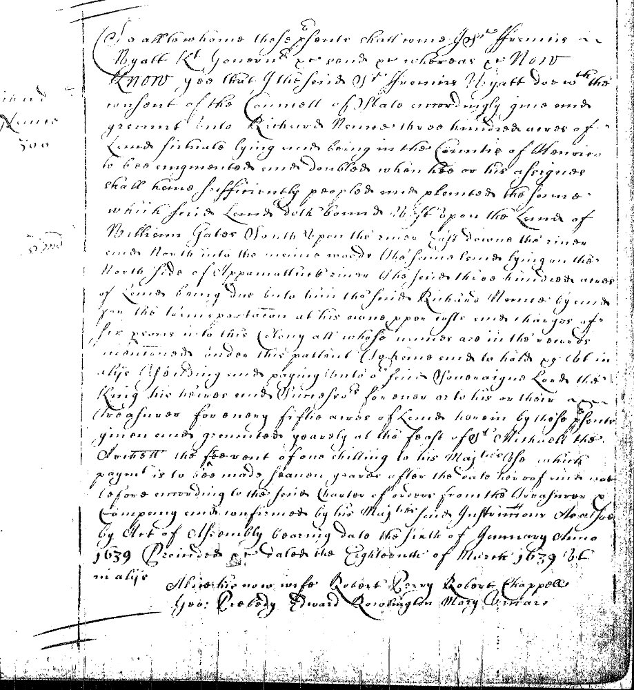 NANCE,
Richard. Land grant 18 March 1639.
NANCE,
Richard. Land grant 18 March 1639. Location: Henrico County.
Description: 300 acres west upon the land of Willm. Gates south upon the river, east down the river &c.
On the north side of Appamattuck River.
Source: Land
Office Patents No. 1, 1623-1643 (v.1 & 2), p. 715
(Reel 1).
Frances Nance (of New Kent Co. VA) 2 Sep 1782 - John ROPER and wife Mary and Frances NANCE (all of New Kent Co. VA) sell Smith BLAKELY (of Henrico Co.) 160 acres in Henrico Co. VA Deed Book 1 pg 31
Henrico Co. VA 5 Nov 1777 William Nance and Mary/Molly his wife (of Henrico) sold Miles Selden Jr 100 acres Henrico Co. VA Deed Book 1 pg 69
HENRY COUNTY, VA
The new county was initially named Patrick Henry County in honor of Patrick Henry.)
HENRY COUNTY
1778 - December 7. James B, SOUTHALL, Williamsburg Co.,
and wife, Frances to Reuben NANCE
(wife Ann Williams), Henry
Co., 525 Pounds, 400 acres, Leatherwood Creek, Bolings
Corner, Rock Branch. Wit: Henry LYNN, George DAVISTON,
Abram PRIM. Bk. 1, p. 194. "Henry, Virginia, United
States Records," images, FamilySearch , image 112 of 724;
Virginia. County Court (Henry County).
(Reuben NANCE, son of William
NANCE Jr. and Ann)
HENRY COUNTY Deed Grantee Inquisition of Lands of James SMITH, 1779 Deed Book 1:311-312 Inquisition on the Land of James SMITH Henry County ___ Inquisition Indented and taken and held by Abraham Penn Escheator for the said County at John WILLSONS [or WILLIAMS] on Southwood Creek in the said County by the Oath of John WITT foreman John PINKARD Daniel RICHARDSON Amos RICHARDSON Spencer Clack James MARTEN [MORTON??] Samuel LUTTREL Reubin NANCE John WYATT John __ CONWAY George HAIRSTON and John DAVIS Good and Lawfull men of the said County who were Impanneled and Returned by John SOLMAN Gent. Sherif of the said County and who after hearing Evidence openly In presence of the said Escheator and Sherif upon their oaths do say that Eleven Tracts or Parcells of Land Containing Four Thousand Six hundred and Ninety five acres, lying on Marrowbone Creek Dee Run the branches of Pigg River & Dee Run and the Branches of Leatherwood Creek in the said County & Bounded by the known and Established lines thereof is at present held as the Estate of James SMITH who is a British Subject & Ought to Vest in the Commonwealth according to the act of Assembly Entitled an act Concerning Escheats & Forfeitures from Brittish Subjects In Witness whereof the said Escheator & the said Jurors their hands and seals to two Indentures of this Time and Date have set and affixed this 1st Day of October 1779.
Abraham PENN Eschr. (seal) (wife Ruth STOVALL)
John Witt FOREMAN (seal)
John PINKARD (seal) (wife Jane)
Daniel RICHARDSON (seal)
Amos RICHARDSON (seal)
Spencer CLARK (seal)
James MARTEN [Morton](seal)
Samuel LUTTRELL (seal)
Reuben NANCE (seal) (wife Nancy Brown)
John WYATT (seal) (wife Agatha Agness Richardson)
John CONNAWAY (seal) (wife Elizabeth Williams)
George HAIRSTON (seal) (wife Elizabeth Perkins)
John DAVIS (seal)
At A court held for Henry County on the 25th Day of November 1779 The above Inquistion was Returned by John WITT formman of the said Inquisition and ordered to be Recorded by the Court. Test. John Cox CHC FHL Film NO. 0031966 Henry County, VA
HENRY COUNTY Inquisition of Land of Archibald SMITH, 1779 Deed Book 1:315-316 Inquisition on the Land of A. SMITH Henry County ___ Inquisition Indented taken and held by Abraham PENN Escheator for the said County at John WITTS's on Southwood Creek in the said County by the Oath of George HAIRSTON Foreman, John PICKARD, Daniel RICHARDSON, Amos RICHARDSON, Spencer CLACK, Joel ESTER Reubin NANCE John W. CONAWAY Samuel PATTERSON James MARTEN & Joseph LEWIS Good and Lawfull men of the said County who were Impannelled and Returned by John SOLMON Gent. Sherif of the said County & whereafter hearing Evidences openly in the presence of the said Escheator & Sherif upon their Oaths do say that two Tracts or Parcells of Land Containing Four hundred & Ninety six acres more or less lying on both sides of Marrowbone Creek & Dee Run in the said County Bounded by the known & Established lines thereof is at present held as the Estate of Archibald SMITH who is a British Subject & ought to Vest in the Commonwealth according to the act of Assembly Intitled an act concerning Escheats & Forfeitures from British Subjects In Witness whereof the said Escheator & the said Jurors their hands & seals to two Indentures of this Time & Day here set and affixed this 1st Day of October 1779 & in the 4th year of the Commonwealth. Abraham PENN Eschr. (seal)
George HAIRSTON (seal) (wife Elizabeth Perkins)
John PINKARD (seal) (wife Jane)
Daniel RICHARDSON (seal)
Amos RICHARDSON (seal)
Joel ESTER (seal)
Reuben NANCE (seal) (wife Nancy Brown)
Saml. LUTTRELL (seal)
John CONNAWAY (seal)
Saml. PATTERSON (seal)
James MARTEN [MORTON??] (seal)
Spencer CLACK [CLARK?] (seal)
Joseph LEWIS (seal) At a court held for Henry County on the 25th Day of November 1779 The above Inquisition was returned by George HAIRSTON forman of the said Inquisition & ordered to be Recorded by the Court. Test John COX CHC FHL Film NO. 0031966 Henry County, VA
HENRY COUNTY - James Barnett Southall (of Williamsburg), and Frances his wife sold (400?) acres to Reuben Nance (of Henry Co.) in Henry Co. VA - Book 1 Page 194 "Henry, Virginia, United States Records," images, FamilySearch : August 23, 2023), image 792 of 887; Virginia. County Court (Henry County).
This Indenture made this 31 January 1797 Peter ( 310 ) Garland of the State of No Carolina County of Rockingham John Haley of the State of Virginia County of Henry John Haley for and in consideration of the sum of five pounds Specie him in hand paid by the said Peter Garland at or before the sealing of these presents the receipt whereof is hereby acknowledged by the sd John Haly hath bargained sold by these presents doth bargain , sell , release , Enfeoff & Confirm Peter Garland his heirs & c forever one certain tract or parcel of Land Situate lying being in the County of Henry State of Virginia my son Barny Haley and Bounded by the lines of John King, Wm Brown, John Nance to a little branch then up the Sd Branch untill it joins the said Wm Browns line thence along his line to the Begining containing one hundred him the said Peter Garland his heirs sd for ever and the said John Haley his heirs & by these presents doth covenant and agree to warrant and by these presents for ever defend unto the said Peter Garland his heirs & c the said tract or parcel of against the claim or claims of any person or persons Whatsoever . In Witness whereof I have hereunto set my hand and seal this day and date above mentioned John Haley . . . . L. S. At a Court held for Henry County 13th Day of January 1799 Indenture was acknowledged by the within named John Haley to be his act & Deed & the same was ordered to be Recorded By the County Teste John Cox LINK
HENRY COUNTY
Page 55 A Entire Page Lee PARISH to Terril NANCE
(need to find rest of info.
1779-1784?)
HENRY COUNTY Deed Bk. 11 p. 143, 1831 Reubin NANCE son of Wm. - July
4, 1780 Land Patent
NANCE,
Reuben. Land grant. 4 July 1780. Location: Henry
County. Description: 182 acres on the draughts of
Leatherwood Creek adjoining Terry's land.
Source: Land
Office Grants A, 1779-1780 (v.1 & 2 p.1-685), p.
560 (Reel 42).
HENRY COUNTY 1784 - February 24 Deed of Trust. John HAILEY of Henry County, to Samuel CALLAND of the county of Pittsylvania, said HAILEY indebted in the amount of 69 pounds 15 shillings, accures with land on the waters of Leatherwood Creek being the land whereon the said HAILEY now lives contains 230 acres, joins lines of William BROWN and John NANCE also 2 mares, stock of cattle, household furniture and plantation tools. To be in effect this date, after 25 Dec. 1795 shall be sold. No wit. Signed John HAILEY
HENRY COUNTY 1784 - September 3. William COCKRAN, Henry Co., to Reuben NANCE, 10 pounds, 170 acres on Leatherwood Creek. Wit: Alegone MAGUIER, Sally NANCE, John MINTER. Bk. 3, p. 92.
HENRY COUNTY 1784 - September 23. William COCKRAN, of Henry Co., to Reuben NANCE, of the same, for 10 pounds, 176 acres on the branches of Leatherwood Creek. Wit : Aleygond MACGWIER, Sally NANCE, John MINTER
HENRY COUNTY 1787 Deed Book pg 292 . Dated 9 April 1787 JOHN ACUFF of Henry County to CAIN ACUFF CAIN ACUFF of the same for the sum of fifty pounds sells 100 acres of land it being part of a tract granted and patented by JOHN ACUFF ACUFF with the lines of JOHN NANCE and the LOMAX & CO . , WIT . JOHN ACUFF ACUFF Lone SARAH ACUFF ACUFF , wife of JOHN , relinquishes her right of dower . Proved : 9 April 1787
HENRY COUNTY - 1787 November 15 James WILLIANS and William BROWN of Henry County to Francis NORTHCUTT of Charlotte County for the sum of 100 pounds sells and conveys 150 acres on both sides of the west side of a fork on Leatherwood Creek Wit:.... Reuben NANCE, .... Proved 9 Jun 1788.
HENRY COUNTY - 1789 November 27 Thomas WILKENS of Henry County to Nicholas AKINS, of the same, for 50 pounds sells 50 acres land on a branch of Leatherwood creek. Wit: Reuben NANCE, ... Proved October Court 1791
HENRY COUNTY Deed Book 4 Page 295 - 1791 - March 22. James HICKS, Brunswick Co., from John NANCE, Henry Co., 100 pounds, 350 acres land on Leatherwood Creek. Neighbors: James HICKS, Charles BURNETT, Robert STOCKTON, Daniel JACKSON, Caine ACUFF, Jnn HAILEY son to James HICKS. Wit: Richard STOCKTON, John MINTER, John HALEY. Bk. 4, p. 295. This Indenture made this Twenty Second Day of March in the Year of our Lord Christ One thousand Seven hundred and Ninety one James Hicks of the County of Brunswick one part and John Nance of the County of Henry of the other part Witnesses that the said James Hicks for and in Consideration of the sum of One hundred Pounds current of Virginia to him in hand paid by the said John Nance the Receipt whereof he doth hereby acknowledge and himself therewith fully and entirely satisfied hath granted bargained sold Aliens Releast and Confirmed and by these presents for himself and his heirs . doth Grant bargain . sell alien release and Confirm the said John Nance his heirs and assigns for ever One parcel of land lying & being in the County of Henry on the waters of Leatherwood Creek containing by estimation Three hundred & fifty acres, Bounded within the lines of James Hicks, Charles Burnett, Robert Stockton, Daniel Jackson, Caine Acuff, John Hailey , son to the said Hicks's line again. With all houses orchards gardens fences woods and underwoods water and water couses thereon standing growing and being with all Profits Commodities advantages and appurtenances whatsoever to the same belonging or any ways appertaining and also the Reversion and Reversions Remainder & Remainder thereof and every part and parcel thereof To have and to hold the said Granted land and premises with their and every of their appurtenances unto the said John Nance his heirs and assigns for ever and he the said James Hicks for himself and his heirs doth - Covenant grant and agree to and with the said John Nance his heirs & assigns that he and they shall and may at all times hereafter peaceably and quietly hold and enjoy the said granted land and premises with the appurtenances free from all former Sales Gifts . Mortgages rites of Dower or any other Icumbrance whatsoever and the the said James Hicks and his heirs shall and will Warrant and for ever defend the said Granted land and premises with the appurtenances unto the said John Nance his heirs and Assigns for ever against all other person or Persons Whatsoever that shall lay any claim their unto and further that the said James Hicks and his heirs shall and will at any timewithin the space of Twenty years him the said John Hand - his heirs & assigns make do and Execute all such Act or Deed for the better Conveying the said Granted land & premises John Nance his heirs or assigns shall devise or require . In Witness whereof the aforesaid James Hicks hath here unto set his hand and Seal this twenty second Day of March one thousand seven hundred 9t us . Signed sealed and delivered in presence of us Richd Stockton James Hicks L. S. John Minter John Haley James Hicks Sen. LINK
(This could be one of 2 John Nance who had a wife named Mary, but most likely Reuben Nance's brother John)
HENRY COUNTY 1792 - December 31. John WYATT of the county of Halifax to Thomas CHAPMAN of Henry County for the sum of 75 pounds sells land in Henry County on the branches of the south fork of Leatherwood Creek and Rock Springs branch. Wit: Reuben NANCE, Benjamin THOMAS and John CONNAWAY
HENRY COUNTY 1793 - October 24. Carter TARRANT and William ACUFF of the county of Henry to John MINTER in consideration of 75 pounds sell land on branch of Leatherwood Creek by estimate 230 acres joins land of Reuben NANCE and John ACUFF. Wit: Leonard Turley, Joseph ANTHONY, Jacob FERRIS, Roday PHILLIPS, John ANDERSON. Signed Carter TARRANT, William ACUFF. Bk. 5 pp. 92-93.
HENRY COUNTY 1794 - February 6. Reuben NANCE and Nancy (BROWN) NANCE his wife of Henry County to Jesse CROUCH(**) for the sum of 50 pounds sells 200 acres more or less on Rocky Branch of Leatherwood Creek. No wit. Signed Ruben NANCE. Proved 30 Mar 1784. Bk. 5, p. 113.
(**Son-in-law? Mary Sarah NANCE, dau. of Reuben NANCE, marr. Jesse Hitler CROUCH)
HENRY COUNTY Deed Book 5 Page 150 - 1795 - April 27. John NANCE and wife Mary NANCE of Henry County, to Bird NANCE, Henry County, 50 pounds, 100 acres more or less on the branches of the south fork of Leatherwood Creek. Bk. 5, p. 150. Neighbors: Charles BURNETT's spring branch, Benjamin RENS. Spring Branch, Hickerol Line, Robert STOCKTON, Col. George HAIRSTON, Burnetts Spring Branch. No wit. Signed: John NANCE. Proved 27 Apr 1795. Bk. 5, p. 150. - 150 This Indenture made the 1st day of April one thousand seven hundred Ninty five John Nance of the County of Henry one part and Bird Nance of the second ┃ County John Nance and Mary his wife for and in - Consideration of the sum of fifty Pounds Virginia to them in hand paid by him the said Bird Nance the receipt whereof he the said Isham Nance & Mary his wife doth hereby acknowledge themselves fully Satisfied Contented and paid hath given granted bargained and sold and by these presents doth give grant bargain sell and confirm him the said Bird Nance one Certain tract or parcel of Land Containing One hundred County of Henry Leatherwood creek to wit , Beginning Maple on Charles Burnette Spring branch thence a Now line E. to the head of Benja Rens Spring Branch Spring Branch Maple then a New line to corn Spanish Oak Robert Stocktons line to Col Geo Hainston line then along said line North to Burnett Spring Branch the first Station him the said Bers Name his heirs Executors administrator and assigns forever to have and to hold use occupy possess and enjoy the same with every part and parcel thereof to him the said Bird Nance his heirs Executors Administrators and assigns forever against them the said John Nance and Mary his wife their heirs assigns Executors and administrators and against the - Claim and demands of any person or persons whatsoever shall and will by these presents warrant and forever defend . In Witness - - John Nance L. S. At a Court of Quarterly Sessions Henry County 27th day of April 1795 Indenture was acknowledged by the within named John Nance to be his act and Deed and the same was Orson the Recorded By the Court - Test John Cox G. C . LINK
(This could be one of 2 John Nance who had a wife named Mary, but most likely Reuben Nance's brother John)
HENRY COUNTY 1796 - September 12. Bird NANCE and wife Mary (HANNAH) NANCE of Henry County to John NIXON, Charlotte County, 65 pounds, 100 acres. Wit: Reuben NANCE, Elijah MOORE, Thomas RICHARDSON. Bk. 5, p. 298.
HENRY COUNTY
1797 - September 24. John MINTER of the county of Henry
to George HAIRSTON of the same for the sum of 150 pounds
sells a tract of land by estimate to be 330 acres more
or less on the branches of the south fork of Leatherwood
Creek, joins lines of Reuben NANCE, Cain ACUFF and MCCULLOCK.
This includes the tenements John MINTER purchased of
Carter TARREN, William ACUFF and Edward HALEY. Wit:
Thomas GRAVES, Nat'l W. DANDRIDGE, Jr. George WALLER,
Jr. Signed: John MINTER. Proved: 25 Sept. 1797.
Bk. 6, pp. 2-3.
HENRY COUNTY
1798 - 5 Oct 1798. Peter PERKINS of Pittsylvania County
to George HAIRSTON of Henry County for the sum of
Seventy five pounds sells all that messuage, plantation
and tract of land on the branches of Leatherwood Creek
in Henry County by deed 175 acres, joins Lomax &
Company, John CONWAY deed to PERKINS, Alexander
MCCULLOCK, Reuben NANCE.
Wit: Joseph MARTIN, John REDD, John MARR, John COX.
Signed Peter PERKINS. Proved: 26 Nov. 1798 & 26 Jan.
1801
HENRY COUNTY 1798 - October 22. Richard STOCKTON and his wife Catherine STOCKTON of Henry County to Philip RYAN of the same for the sum of 200 pounds sells and conveys a tract of land, 200 acres more or less on the Rockey Branch of Leatherwood Creek joins Reuben NANCE's old line. Wit: William BROWN, Ann STOCKTON, Dorics STOCKTON,. Signed: Robert STOCKTON, Catherine STOCKTON. Proved: 29 Sept. 1801.
HENRY COUNTY 1799 - November 1. John NANCE and Mary NANCE his wife, (of Henry County), to John WILLS, (of Brunswick County), for a sum of money convey a tract of land containing 240 acres in Henry County on Leatherwood Creek. Neighbors: George KING, Burnett, L. NIXON, HARSTON, Leng HAINTON, Hale. Wit: John KING, Joseph NIXON, William DESHAGO, Charles JONES. Signed: John NANCE and Molly (cox) NANCE. Bk. 6, p. 207. - 207 This Indenture made this first day of November one thousand seven Hundred and ninety nine John Nance & Mary his Wife of the County of Henry and State of Virginia one part & John Wills of Brunswick County John Nance & Mary Nance for and In considertion of a certain sum of money paid by sd Wills the receipt whereof wide Heareby Acknowledge have Bargaind granted and sold and by these presents we do grant Bargin and sell Wills his heirs and assigns forever one certain part or Parcel of Land Containing two Hundred & forty County of Henry Leatherwood Creek Bounded as follows to wit ┃ Begining George Kings Corner Chesnut thence South on Hanstons line to a branch Calld Brunetts Spring Sd Branch Nixons line to Sd Nexons Corner papret thence east long Nixons line to asepler at the head of alson = thence Sd Branch Spanish Oak corn long Stocktons line to a corner popler thence same was on Harstons line through an old field to porten at afor Red Corner still Oak thence North east was Long Houston line W Halls Corner While oak on checut Thence north west long Halls line to a branch thence long Garlands linesd ⌨ up abottem to the top of the Hill to George Kings Corner Tisboak thence on sd Kings line South West cours Warner White oak Kings thence South corse On sd line to a corner beach on a branch thence up sd band as it meanders Tokings Corner Maprel thence South to the Begining aforesaid John Nance & Mary his wife of in and to the sd Tract of or parcel of land with its appertainance to have and to The said Land and premises John Wills & his heirs and assigns forever And we said Nance & Wife our heirs all and singular the sd Preminises with Appertainances against him the said Nance and Wife & our heirs and all and every other Person or persons whatsoever unto the said Wills his heirs and Assigns Weshall & will for ever warrant and defend by these presents In Witness Whereof in the sd Nance & wife have here unto set our hands & seals the day & year ┃ above written John In Presents of ⎬ John King Sun , John Nance Lock Joseph Nexson William Deshay ⎬ Molly Nance L S. ✓ John Ris Ala Charles Jones At a Court held for Henryles unty on the 27th day of January 1800 Indenture was acknowledged by the within named John Nance to be his act & Deed & Molly the wife of the said John Nance being prively Examined as the Law directs relinquished her right of Dower in & to the land & premisses conveyed by her said husband in the said Indenture and the Examd delivd same was ordered to be Recorded By the Court Pette John Core LINK(This could be one of 2 John Nance who had a wife named Mary, but most likely Reuben Nance's brother John)
HENRY COUNTY 1801 - March 10. Alexander McCULLOCK and Lydia McCULLOCK his wife, to Reuben NANCE for the sum of 80 pounds sells land on the Rock Branch of the south fork of Leatherwood Creek, 40 acres that joins NANCE, No Wit. Signed Alexander (X) McCULLOCK. Proved: 25 May 1801. Bk. 6, p. 293.
HENRY COUNTY 1801 - March 10. Alexander McCULLOCK and Lydia McCULLOCK his wife of Henry County to Reuben NANCE of the same for the sum of 80 pounds sells land on the waters of Leatherwood Creek and Rockey Branch. No Wit. Signed Alexander (X) McCULLOCK. Proved: 24 May 1801. Bk. 6, p. 300-301.
HENRY COUNTY 1801 - Richard STOCKTON, Franklin County, agent for Robert STOCKTON of Barron County KY., to Nancy (BROWN) NANCE, wife of Reuben NANCE, deceased, 200 pounds, 100 acres, South Fork of Leatherwood Creek. Nancys HEIRS: Sally PHILLPOT, Stephen NANCE, Peyton NANCE, Edmond NANCE, Nancy (BROWN) NANCE, Reuben Saunders NANCE. Bk. 7, p. 437. Proved 25 May 1801
HENRY COUNTY No Date. Inquisition ordered and taken 15 March 1803 to summon and empower a Jury at the plantation of Aris VAUGHAN on Reed Creek to ascertain damage that VAUGHAN would sustain by a road going through his land. Jury: John JAMISON, Carr WALLER, John CAHILL, Stephen KING, , John HOMES, Junor MEREDITH, James HOWARD, William HEARD, Shadrack DENT, William WARREN, Isham NANCE, James MURPHEY declare damages would be 12 pounds 10 shillings. Proved: 28 Mar. 1803. Bk. 6 p. 426
HENRY COUNTY Reubin NANCE. Land grant. 25 April 1804. Description: 133 acres on the waters of Leatherwood Creek adjoining Pedigoe’s line.
Source: Land Office Grants No. 53, 1804, p. 50 (Reel 119).
HENRY COUNTY 1805 - September 30. William STOKES of Henry County to George HAIRSTON of the same for the sum of 300 pounds sells 232 acres on Beaver Creek joins Joseph ANTHONY, Isham NANCE, Henry CLARK, Jacob FARRIS and Carr WALLER. Signed: William STOKES. Proved: 30 Sept. 1805. Bk. 6, pp. 644-646.
HENRY COUNTY 1805 - November 25. Bond of James DYER appointed Constable his bondsmen Benjamin DYER and Reuben NANCE. Bk. 6, p. 654
HENRY COUNTY 1805 - September 6. Inquist at a place called the Narrowson Smith River to view the body of James SMITH blacksmith. Jury John COX, William STOKES, John S. WOODSON, James BAKER, James MURPHY, Francis MURPHY, Bartlett WADE, Isom NANCE, George WALLER, William DRAPER, William FRENCH, Joseph PHIFER, The said James SMITH drowned by accident in the Smith River. Proved 30 Dec. 1805. Bk 6, p. 655.
HENRY COUNTY 1817 - Isham NANCE, Grantor. George HAIRSTON, Grantee. Isham NANCE and wife Polly sells George HAIRSTON 245 acres land left to Polly by her father (Frederick MALONE) - Bk. 8, p. 215.
HENRY COUNTY 1824 - EDMUND NANCE, et. al., Grantors; George HAIRSTON, - Grantee, - Stephen Nance (of Tennessee), Peyton Nance, Edmond Nance, Lessonby Nance, Reuben S Nance (by his guardian Lessonby Nance), David Philpott and Sally his wife (of Patrick Co.), Benjamin Marshall and Nancy his wife (of Henry Co.) sold George Hairston (of Henry Co. VA) 100 acres on both sides of the south fork of Leatherwood Creek - Bk. 10, p. 38. "Henry, Virginia, United States Records," images, FamilySearch, image 638 of 887; Virginia. County Court (Henry County).
HENRY COUNTY 1823 - TERRELL NANCE, Grantor; Nelson NORMAN Grantee, - Terrell NANCE and his wife Elizabeth (Formerly Elizabeth OAKES) sold to Nelson NORMAN 1/6th part of a certain tract of land on north side of Smith's River belonging to the heirs of James OAKES - Bk. 10, p. 49. "Henry, Virginia, United States Records," images, FamilySearch, image 643 of 887; Virginia. County Court (Henry County).
HENRY COUNTY 1824 - TERRELL NANCE, Grantee; Hopper TERRELL, Grantor, - Terrell HOPPER and Rhodah his wife sold Terrell NANCE 135 acres on the north side of Smith's River - "Henry, Virginia, United States Records," images, Book 10 p. 64 image 651 of 887; Virginia. County Court (Henry County).
HENRY COUNTY 1825 - LESSENBY NANCE, Grantee; Reuben NANCE's heirs, et. al., Grantors, - David PHILPOTT and Sally his wife (of Patrick Co.), Peyton nance and Nelly his wife, Edmund Nance and Anna his wife, Benjamin Marshall and Nancy his wife, Reuben Sanders Nance by Lessonby his guardian, Lessonby and Oney his wife sold 164 acres to Lessonby Nance - Bk. 10, p. 129. "Henry, Virginia, United States Records," images, FamilySearch,image 683 of 887; Virginia. County Court (Henry County).
HENRY COUNTY 1825 - EDMUND NANCE, et. al., Grantors; Benjamin MARSHALL, Grantee, - David Philpott and Sally his wife (of Patrick Co.), Payton Nance and Nelly his wife, Edmund Nance and Anna his wife, Lessonby Nance and Oney his wife, and Reuben Sanders Nance by Lessonby Nance, his guardian sold to Benjamin Marshall and Nancy (NANCE) his wife 164 acres in Henry Co. VA - Bk. 10, p. 130. "Henry, Virginia, United States Records," images, FamilySearch image 684 of 887; Virginia. County Court (Henry County).
HENRY COUNTY 1825 - EDMUND NANCE, Grantee; Lessenby NANCE, Peyton NANCE, Grantors. - David Philpott and Sally his wife (of Patrick Co.), Peyton Nance and Nelly his wife, Lessonby Nance and Oney his wife, Benjamin Marshall and Nancy (NANCE) his wife, and Reuben Sanders Nance by his guardian Lessonby Nance sold 164 acres to Edmund Nance and Anna his wife - Bk. 10, p. 132. "Henry, Virginia, United States Records," images, FamilySearch, image 685 of 887; Virginia. County Court (Henry County).
HENRY COUNTY 1825 - PEYTON NANCE, Grantee; Lessenby NANCE, Edmund NANCE, Grantors, - David Philpott and Sally his wife (of Patrick Co.), Edmund Nance and Anna his wife, Lessonby Nance and Oney his wife, Benjamin Marshall and Nancy (NANCE) his wife, , and Reuben Sanders Nance by his guardian Lessonby Nance, sold 164 acres in Henry Co. VA to Peyton Nance and Nelly his wife - Bk. 10, p. 133. "Henry, Virginia, United States Records," images, FamilySearch, image 685 of 887; Virginia. County Court (Henry County).
HENRY COUNTY 1826 - TERRELL NANCE, Grantor; Barney CAHILL, Grantee, - Terrell NANCE and Elizabeth his wife sold Barney Cahall 135 acres +/- on the north side of Smith's River - Bk. 10, p. 163. "Henry, Virginia, United States Records," images, FamilySearch, image 701 of 887; Virginia. County Court (Henry County).
HENRY COUNTY 1826 - TERRELL NANCE, Grantee; - Eliz. MURPHY, Polly's Atty, Grantors, John Odle (attorney) for Elizabeth Murphy and Polly Murphy (of Franklin Co. KY) sold 189 acres in Henry Co. VA to Terrell Nance (of Henry Co. VA) - Bk. 10, p. 224. "Henry, Virginia, United States Records," images, FamilySearch, image 732 of 887; Virginia. County Court (Henry County).
HENRY COUNTY 1827 - PEYTON S. NANCE, Grantor; Charles M. WINGFIELD, Grantee, - Peyton S. NANCE and Elanor his wife sold Charles M Wingfield and Samuel Marshall 164 acres in Henry Co. VA - Bk. 10, p. 345. "Henry, Virginia, United States Records," images, FamilySearch, image 792 of 887; Virginia. County Court (Henry County).
HENRY COUNTY 1830 - EDMUND NANCE, Grantee; Lessenby NANCE, Grantor, Bk. 11, p. 35.
HENRY COUNTY 1831 - TERRELL NANCE, Grantee; Harding {Harden} NANCE, Grantor, Bk. 11, p. 120.
HENRY COUNTY 1831 - EDMUND NANCE, Grantor; Joseph MARTIN, Grantee, Bk. 11, p. 125.
HENRY COUNTY 1831 - TERRELL NANCE, Grantor; Lee PARISH, Grantee, Bk. 11, p. 143.
HENRY COUNTY 18 Dec 1840 - Between John PRICE and Lucy his wife and HARDIN NANCE, 100 acres on the waters of Stewart Creek, Bk. 12, p. 302.
HENRY COUNTY 21 Sep 1842 - Between DAVID NANCE and James HOPPER whereas David NANCE is in debt to Patrick F. HOPPER for $40 for a gray mare, Bk. 12, p. 528.
HENRY COUNTY 1844 - DAVID NANCE & & S. T. HAIRSTON & James B. NORMAN David NANCE is indebt to James B. Norman in the sum of $41.80 for some personal property items. Deed Book 13 Page 33
HENRY COUNTY 1844 - FONTAINE NANCE, Grantee; Peter C. COX, Grantor, Bk. 13, p. 75.
HENRY COUNTY 1844 - NANCE from COX - Peter C. COX and Polly his wife & Fontain NANCE - 88 acres on both sides Stewert's Creek Deed Book 13 Page 75
HENRY COUNTY 1850 - Benjamin A MARSHALL and wife Nancy (NANCE*) MARSHALL to Reuben MARSHALL - 250 acres on branches of south Leatherwood Creek Deed Book 13 Page 682
"Henry, Virginia, United States Records," images, FamilySearch image 718 of 756; Virginia. County Court (Henry County).
(*Dau. of Reuben NANCE and Nancy BROWN)
HENRY COUNTY 15 Aug 1850 - William CLIFTON (of Patrick County, VA) and Henry NANCE (of Rockingham Co., NC) 26 acres on the waters of Matrimony Creek Deed Book 13 Page 748
"Henry, Virginia, United States Records," images, FamilySearch, image 751 of 756; Virginia. County Court (Henry County). Recorded Dec 1850.
(I believe his is the Henry Nance (wife Mary HARRIS) )
HENRY COUNTY 1858 - FONTAINE NANCE and Gemima his wife, Grantor; James W TRENT and Dorithy (KING) his wife, Grantee, 203 1/4 acres; 14 Oct 1758 k. p. 37.
HENRY COUNTY 1859 - TURLEY (TERRELL) NANCE, Grantor; Archibald GRANT, Grantee Bk p. 2
HENRY COUNTY 1859 - PLEASANT NANCE, Grantee; Charles A BARKER and wife Elizabeth and James M BARKER and wife Mary BARKER , Grantor 30 Jul 1859; Bk p. 144
This ended up in chancery court, Pleasant won, did not have to pay the BARKERS, because he purchased this land outright from father-in-law Allen BARKER
HENRY COUNTY 1860 - FOUNTAIN NANCE, Grantor; James ODLE & Adaline his wife, Grantee 20 Nov 1860 Bk p. 342
HENRY COUNTY 1862 - FONTAINE NANCE and Peter HAIRSTON and his wife S. J.; 31 acres 21 Oct 1862 Bk p. 427
JAMES CITY COUNTY
Source: Land Office Patents No. 8, 1689-1695, page 231 page 232 (Reel 8).
KING WILLIAM COUNTY
Land grant 28 October 1702. Creator Davis, Robert. grantee. Creation Date 1702 Location: King William County. Grantee(s): Davis, Robert and Davis, Mary.
Description: 137 acres in St. Johns Parish in Pamunkey Neck beginning and in Wm. Lipscomb's line and on Nickaty Nance Swamp.
Source: Land Office Patents No. 9, 1697-1706 (v.1 & 2 p.1-742), p. 490 (Reel 9).
(might not be a Nance connection)
Land grant 28 October 1702. Creator Mackgheehee, Thomas. grantee. Creation Date 1702 Location: King William County.
Description: 256 acres in Pamunkey Neck on the west side of Nicaty Nance Swamp, beginning on the east side of said swamp.
Source: Land Office Patents No. 9, 1697-1706 (v.1 & 2 p.1-742), p. 483 (Reel 9).
(might not be a Nance connection)
LEE COUNTY
Source: Land Office Grants No. 44, 1799-1800, p. 133 (Reel 110).
Source: Land Office Grants No. 43, 1799-1800, p. 203 (Reel 109).
LUNENBURG COUNTY VA Deed Book 2 Page 87- 88
Benjamin HAWKINS to George WALTON 5 Feb 1749 1,240 acres - Both sides of North fork of Meherrin
Adj: Richard NANCE Rec: 3 Jul 1750 HAWKINS Patent half of 2480a 20 May 1749 [see VACC007]
Other half HAWKINS to MITCHELL 3 Oct 1751 [see VACC023] Repatented by Walton 1240a 5 Feb 1757 [see VACC016] Page 87
This Indenture made this 5 Feb 1749 Between Benjamin HAWKINS of Amelia County of the one part and George WALTON of Lunenburg County of the other part Witnesseth that the said Benjamin HAWKINS for and in consideration of the sum of £82/10 current money of Virginia ... a certain tract or parcel of land lying and being in Lunenburg County aforesaid on both sides of the North fork of Meherrin River containing by estimation 1,240 acres be the same more or less Bounded as follows viz. Beginning at Richard NANCE's corner white oak 54 poles by his line from the said River thence a new line South 73 West 6210 poles to a red oak Thence Northwardly by the courses of a patent granted to the said Benjamin HAWKINS dated 20 May last [1749 os] to the first station ( being part of 2,480 acres) Together with all ... Page 88 Benjamin HAWKINS for himself ... Signed Sealed & Delivered in presence of us Benjamin HAWKINS, Peter WINFREE, Thomas CRANSHAW, James BREADLOVE, John WILLINGHAM Junr ... At a Court held for Lunenburg County the 3 Jul 1750 the within Indenture ... Ordered to be recorded
LUNENBURG COUNTY VA Land Patents Book 27 Page 194-196
Benjamin HAWKINS 20 May 1749
£12/5s - 2,480 acres - Both sides Owl Creek
Both sides North Fork Meherrin River
Adj: John NANCE [Jr], Richard NANCE
HAWKINS to WALTON 1240a 5 Feb 1749
HAWKINS to MITCHELL 1240a 3 Oct 1751 Page 194 Page 195 ... £12-5s ... unto Benjamin HAWKINS one certain tract or parcel of land containing 2,480 acres lying and being in the County of Lunenburg on both sides of the North Fork of Meherrin River and both sides Owl Creek and bounded as followeth, to wit, Beginning at a hiccory in John NANCE's upper line on Owl Creek thence a new line North 10 East 296 poles to a hiccory in Richard NANCE's line thence on his lines North 64 West 74 poles to a white oak thence North 27 West 54 poles to a walnut on the said River thence up the River as it meanders to a mulberry thence North 54 East 102 poles to a spanish oak thence new lines North 5 West 108 poles to a red oak thence North 57.5 West 300 poles to a pine thence South 75 West 160 poles to a white oak thence South 28 West 576 poles crossing the River to a red oak thence South 32 East 220 poles crossing Owl Creek to a red oak thence East 260 poles to a maple in a fork of the said Creek and thence down the Creek as it meanders to the first station. ... Page 196 ... 20 May 1749 ...
LUNENBURG COUNTY VA Land Patents Book 27 Page 234-235 William COVINGTON 25 Jul 1749 400 acres - Both sides Hurricane Branch Meherrin River John COOK VAPB 36:770 400a 26 Jul 1765 [see VAXX006] Page 234 ... unto William COVINGTON ... 400 acres lying and being in the County of Lunenburg on both Sides of the Harricane Branch of Meherrin River and bounded as followeth, to wit, Beginning at a white oak in the said Branch thence new lines North 10 West 164 poles to a Hiccory thence South 80 West 114 poles to a white oak thence North 77 West 200 poles to a red oak thence South 75 West 100 poles to a Hiccory thence South 10 East 152 poles crossing the North Fork of the Branch to a pine and thence South 88 East 406 poles crossing the south Fork of the same to the first station ... 25 Jul 1749 ... [Repatented to John Cook]
LUNENBURG COUNTY VA NANCE, John. Land grant 25 July 1749. Location: Lunenburg County. Description: 385 acres on both sides the north fork of Dry Creek adjoining land of Wynn, and Nicholas Christophers land..
Source: Land Office Patents No. 27, 1748-1749, p. 247 (Reel 25).
VA Land Patents Book 27 Page 247-248 John NANCE 25 Jul 1749
40s - 385 acres - Both sides North Fork of Dry Creek
Adj: Nicholas CHRISTOPHER VAPB 25:244 1746
Adj: Richard WYNN VAPB 27:274 1749
Adj: TUCKER/BLUE VAPB 33:057 1756
John NANCE Jr to CHRISTOPHER 385a 1756
Adj: CHRISTOPHER VAPB 25:244 388a 12 Jan 1746
Adj: WYNN VAPB 27:274 425a 25 Jul 1749
Adj: FLAKE VAPB 29:250 395a 12 Jul 1750
Adj: TUCKER/BLUE VAPB 33:057 400a 16 Aug 1756
Adj: HARDY VAPB 34:105 200a 16 Aug 1756
Adj: CHRISTOPHER VAPB 34:999 100a 25 Mar 1762 Page 247 ... 40s ... unto John NANCE one certain tract or parcel of land containing 385 acres lying and being in the County of Lunenburg on both sides the North Fork of Dry Creek and bounded as followeth, to wit, Beginning at WYNN's corner maple on the said Fork thence on his line North 10 East 222 poles to Dunkin BLUE's corner pine in the same thence on his line South 50 West 406 poles crossing two large branches to his corner hiccory thence new lines the same course continued 70 poles to a pine thence South 80 East 74 poles to a red oak thence South 70 East 190 poles to pointers in Nicholas CHRISTOPHER's line thence on his line North 37 East 170 poles to the said Fork and thence up the said Fork as it meanders to the first station ... Page 248 ... 25 Jul 1749
VACC001.DOC Lunenburg Co VA Land Patents Book 27 Page 247-248 John NANCE 25 Jul 1749 40s - 385 acres - Both sides North Fork of Dry Creek Adj: Nicholas Christopher [VAPB 25]:244 1746 [see VAXX010] Adj: Richard Wynn
LUNENBURG COUNTY VA Land Patents Book 27 Page 274-276 Richard WYNN 25 Jul 1749 425 acres - On both sides of Dry Creek (Adj: John NANCE see VACC001) (Nicholas CHRISTOPHER [seeVAXX010] TUCKER/BLUE [see VAXX009}) Page 274 Page 275 .. unto Richard WYNN one certain tract or parcel of land containing 425 acres lying and being in the County of Lunenburg on both Sides of Dry Creek and bounded as followeth, to wit, Beginning at Crews their corner ash on the said Creek thence on their lines North 61 poles to a white oak thence new lines North 12 West 452 poles to a hiccory thence South 70 West 103 poles to a red oak South 20 East 92 poles to a white oak thence South 10 West 292 poles to a maple on the North Fork of the Creek thence down the said Fork as it meanders to Nicholas CHRISTOPHERS line thence on his lines North 37 East 50 poles to a white oak thence South 48 East 108 poles to a hiccory on the main Creek thence down the Creek as it meanders to the first station ... Page 276 ... 25 Jul 1749
LUNENBURG COUNTY VA Deed 3 Oct 1749 Daniel and Elizabeth NANCE to Thomas MALONE Deed Book 1 pg 473
LUNENBURG COUNTY VA Land Patents Book 29 Page 212 John HALL 1 Jun 1750 £6-10s - 1300 acres - Both sides of Springfield Creek Hall to Walton part of [see VACC016] ... £6-10s ... unto John HALL ... 1,300 acres ... Lunenburgh on both sides of Spring Field Creek ... Beginning at a pine thence new lines North 40 West 524 poles to an ash on a branch of the same thence South 70 West 210 poles to a pine thence South 40 East 370 poles to a red oak thence South 50 East 494 poles to a red oak thence North 30 East 388 poles to a pine thence North 60 West 216 poles to a red oak thence South 30 West 190 poles to the first station ... 1 Jun 1750
NANCE, Richard. Land grant 1 June 1750. Location: Lunenburg County. Description: 210 acres on both sides of Meherrin River.
Source: Land Office Patents No. 29, 1749-1751 (v.1 & 2 p.1-532), p. 225 (Reel 27).
LUNENBURG COUNTY VA Land Patents Book 29 Page 225
Richard NANCE 1 Jun 1750
25s - 210 acres - Both sides of Meherrin River
Richard NANCE to Nathaniel NANCE 105a 21 Sep 1759
Richard /John/ to FOSTER 105a 22 Sep 1759
Adj: George WALTON Patent 5 Feb 1757
Adj: Benjamin HAWKINS Patent 20 May 1748
Adj: William WEST Patent 10 Jul 1767 Page 255 ... 25s ... unto Richard NANCE one certain tract or parcel of land containing 210 acres lying and being in the County of Lunenburgh on both sides of Meherrin River and bounded as followeth, to wit, Beginning at a Mulberry on the River thence new lines North 40 East 102 poles to a Spanish oak [sic North 54E 102 poles in WALTON & HAWKINS patents] thence South 64 East 234 poles to pointers thence South 26 West 140 poles crossing the River to a white oak thence North 64 West 180 poles to a white oak thence North 27 West 54 poles to a walnut on the River and thence up the River as it meanders to the first station ... 1 Jun 1750
VACC008.DOC Lunenburg Co VA Land Patents Book 29 Page 225 Richard NANCE 1 Jun 1750 25s - 210 acres - Both sides of Meherrin River
Richard to Nathaniel 105a 21 Sep 1759
LUNENBURG COUNTY VA Deed 3 Jul 1750 Daniel NANCE to Drewry MALONE Book 2 Page 11
LUNENBURG COUNTY VA Land Patents Book 29 Page 250-251 Samuel FLAKE 12 Jul 1750 395 acres - On head branches North Fork of Dry Creek (Adj: John NANCE [see VACC001]) Page 250 ... unto Samuel FLAKE one certain tract or parcel of land containing 395 acres lying and being in the County of Lunenburg on the head branches of the North Fork of Dry Creek and bounded as followeth, to wit, Beginning at Philip PLEDGERS corner pine thence on his line North 50 East 68 poles to Dunkin BLUES corner hiccory thence on his lines North 80 West 124 poles to a white oak thence North 25 East 246 poles to John MITCHEL's corner white oak thence on his line South 70 West 240 poles to Coles corner pointers in a meadow thence on his line South 60 West 102 poles to his corner red oak in James OLIVER's line thence on his line South 45 East 28 poles to a red oak thence South 184 poles Page 251 to pointers thence new lines North 80 East 254 poles to pointers and thence North 50 East 8 poles to the first station ... 12 Jul 1750
LUNENBURG COUNTY VA Deed Book 2 Page 176-177 Benjamin Hawkins to Barney WELLS 26 Nov 1750 350 acres - Both sides Little Owls Creek Rec: 2 Apr 1751 Benjamin Hawkins Patent 350a 25 Jul 1749 VAXX014 Wells to Thompson ? This Indenture made this 26 Nov 1750 between Benjamin Hawkins of Amelia County one party and Barne Wells of the other party Witnesseth that the said Benjamin Hawkins for and in consideration of the sum of £40 current money of Virginia ... 350 acres of land on both sides the Little Owl's Creek in [too faint] ... Beginning at a white oak on the said Creek thence South 51 West 26 poles to a white oak thence South 24 West 46 poles to a pine thence South 58 West 148 [poles] to a pine thence North 83 West 46 poles to a elm on Little Owl's Creek thence up the said Creek as it meanders to a white oak on the same thence North 11 East 94 poles to a white oak thence North 30 East 256 poles to a white [oak] on the Creek thence down the Creek as it meanders to the beginning ... Benjamin Hawkins Wit: Samuel Ingrom, Richard Tomson, Argil (P his mark) Blackston, Joseph Billups, Martha Walton. Rec: 2 Apr 1751
LUNENBURG COUNTY VA Deeds Book 3 Page 309-311 Timothy Murrell & Richard Prewit to George Walton 31 Dec 1750 £60 - 65 acres Both sides of Springfield Creek Mill and Mill pond Patent Murrell & Prewit 465 acres 1 Jun 1750 VAXX017 Page 309 This Indenture made this 31 Dec 1750 between Timothy Murrell of Amelia County & Richard Prewit of King and Queen County of the one part and George Walton of Lunenburg County of the other part. Witnesseth ... £60 ... give, grant Page 310 bargain ... one certain tract or parcel of land containing 65 acres together with a mill thereon be the same more or less situate lying and being in Lunenburg County on both sides of Springfield Creek it being part of 465 acres granted the said Murrell and Prewit by Patent dated 1 Jun 1750 [this present year] bounded viz: Beginning at a white oak by the side of the said mill pond thence new lines South 70 East 36 poles to a red oak South 26 East 56 poles to a black walnut on the said Creek thence down the same and a small stream or slush strait to a small Spanish oak by the side of the said stream thence off South 20 East 38 poles to a red oak in the said Patent line thence along the Patent lines South 60 West 35 poles to a hickory North 55 West 140 poles to a pine North 16 West 43 poles to a small white oak by the mill path thence a new line North 57 East 17 poles to a small white oak by the side of the said mill pond thence up Page 311 crossing & down the same including all that shall be overflowed by the said Mill to the first station ...
Melons, Drury. Land grant 5 August 1751. Location: Lunenburg County. Description: 970 acres in the Counties of Lunenburg, and Brunswick on both sides of Jeneto Creek, adjoining William NANCE.
Source: Land Office Patents No. 29, 1749-1751 (v.1 & 2 p.1-532), p. 480 (Reel 27).
LUNENBURG COUNTY VA Deed Book 2 Page 281-282
John NANCE of Lunenburg Co to George Wells 4 Sep 1751
£70 -200 acres - South side Meherrin River, Owl's Creek
John NANCE Patent 400a 28 Aug 1746
Rec: 1 Oct 1751 Page 281 This Indenture made the 4 Sep 1751 Between John NANCE of Lunenburg County of the one part and George WELLS of Orange County of the other part Witness that the said John NANCE for and in consideration of the sum of £70 current money of Virginia ... one certain tract or parcel of land situate lying and being in the County of Lunenburgh on the South Side of Meherrin River containing by estimation 200 acres be the same more or less it being the one half of 400 acres granted the said John NANCE by patent dated 28 Aug 1746 bounded viz: Beginning at the said patent corner white oak on the said River thence new lines South 75 West 40 poles to a small pine South 44 West 144 poles to pointers in the said patent line Thence along the said patent line North 55 West to Owl's Creek and so round according to the bounds of the said patent to the first station with all and singular ... Page 282 To him the said George WELLS ... In witness whereof ... In the presence of us John NANCE George WALTON, Barnaby WELLS, Francis Moor Petty Richard TOMSON Memorandum 4 Sep 1751 Quiet and peacable possession ... and quiet possession and seizen of the within mentioned ... and made by John NANCE to George Wells ... of the within written Deed in presence of us John NANCE, George WALTON, Barnaby WELLS, Francis Moor Petty Richard TOMSON At a Court held for Lunenburgh County 1 Oct 1751 This indenture and the Memorandum of Livery of Seizin hereon endorsed were by three of the witnesses theretp enscribed proved to be the act and deed of the above named John NANCE and the same was Ordered to be Recorded. Clement Read
VACC006.DOC Lunenburg Co VA Deed Book 2 Page 281-282 John Nance of Lunenburg Co to George Wells 4 Sep 1751 £70 -200 acres - South side Meherrin River, Owl's Creek John Nance Patent 400a 28 Aug 1746 [see VACC005] Rec: 1 Oct 1751
LUNENBURG COUNTY VA Deed Book 2 Page 337-338
Benjamin HAWKINS to James MITCHELL 3 Oct 1751 £100 - 1,240 acres - South side of Meherrin River
Adj: Thomas NANCE, John NANCE, George WALTON
Rec: 3 Oct 1751 HAWKINS Patent 2480a 20 May 1748 [see VACC007]
HAWKINS to WALTON 1240a 5 Feb 1749 [see VACC022]
MITCHELL to FOSTER 940a 23 Feb 1758 [see VACC033]
MITCHELL to MASON 300a 3 Feb 1758 VAXX002 Page 337 This Indenture made this [ ] day of [ ] in 1751 Between Benjamin HAWKINS of the County of Amelia of the one part and James MITCHELL of the same county of the other part Witnesseth that the said Benjamin HAWKINS for and in consideration of the sum of £100 current money of Virginia ... a certain tract or parcel of land lying and being in the County of Lunenburg containing 1,240 acres joining the lands of Thomas NANCE, John NANCE and George WALTON and being the one half of a tract granted the said Benjamin HAWKINS for 2,480 acres by patent bearing date 20 May 1749 the other half of the said patent being sold and conveyed by the said Benjamin Hawkins by a deed of feoffment to George WALTON as by the said patent and deed reference thereto and is all the residue of the said tract and all the rights ... Page 338 Wit: Clement READ, Ben HAWKINS, Ben HARRIS, George WALTON, Thomas WILLIAMSON Rec: 3 Oct 1751
LUNENBURG COUNTY VA Land Patents Book 30 Page 499-500 James Roberts 4 May 1752 935 acres - Both sides of Meherrin, on Hurricane Creek, Liles Creek Adj: Mann, Williams, Willingham, Blackgrave, Allen, Malone, Michaux Page 499 ... containing 935 acres lying and being in the County of Lunenburg on both sides Meherrin River and bounded as followeth to wit: Beginning at Catlett Mann's corner beech on the River thence along his lines South 72 West 88 poles to a pine South 82 West 72 poles to a white oak on the Hurricane Creek North 44 West 26 poles to a hickory thence a new line South 10 West 115 poles to a poplar on a Branch thence up the same as it meanders to a poplar in Williams's line thence along his lines South Page 500 80 East 117 poles to a white oak South 20 East 292 poles to a pine thence along Willingham's line South 10 East 10 poles to a white oak on a rock by Liles's Creek thence down the Creek as it meanders to Blackgrave's corner poplar thence along his lines North 24 East 60 poles to a red oak North 70 East 58 poles to a red oak near the River aforesaid by the side of a sunken place thence down the river as it meanders to the patent corner red oak thence along the said lines North 40 East 126 poles to a red oak North 28 West 228 poles to an elm on the River thence along Allen's lines North 35 East 54 poles to a red oak North 76 East 110 poles to Malone's corner pointers thence along his line North 180 poles to a white oak in Michaux line thence along his lines South 52 West 110 poles to a pine West 112 poles to a white oak on the said River and thence up the same as it meanders to the first station 270 acres part thereof being formerly granted unto James Ferguson by our letters patent bearing date 20 Sep 1745 the right and title of which said land is since vested in the said James Roberts and 640 acres the residue never before granted
NANCE, Thomas. Land grant 27 July 1753. Location: Lunenburg County. Description: 290 acres on the south side of Harricane Creek adjoining Coventon, Williams, &c.
LUNENBURG COUNTY VA Land Patents Book 31 Page 341-342
Thomas NANCE 27 Jul 1753 Creation Date 1753 - 0727 Location: Lunenburg County. Description: 290 acres on the south side of Harricane Creek adjoining Coventon, Williams, &c.
Source: Land Office Patents No. 31, 1751-1756 (v.1 & 2 p.1-751), p. 341 (Reel 29).
30s - 290 acres - South Side of Harricane Creek
Adj: William COVINGTON
Adj: James WILLIAMS
Adj: Catlett Mann 400a 12 Jan 1746
NANCE to Irwin 190a 7 Aug 1753
NANCE to Gwin 100a 7 Aug 1753
Gwin to Pool 100a 2 Aug 1757
Pool to Fullilove 100a 15 Dec 1762 Page 341 ... 30s ... unto Thomas NANCE one certain tract or parcel of land containing 290 acres lying and being in the County of Lunenburgh on the South side of Harricane Creek and bounded as follows to wit: Beginning COVENTON 's corner white oak on the said Creek thence along his line South 88 West 70 poles to WILLIAMS's corner red oak in the same thence along his lines South 266 poles to a pine South 80 East 78 poles to a poplar on a Branch thence down the same as it meanders to a corner poplar thence a new line North 10 East 115 poles to a hickory in Man's line thence along his lines North 44 West 40 poles to a corner North 5 East 60 poles to the Creek aforesaid & thence up the same as it meanders to the first station ... Page 342 ... 25 Jul 1753
VACC009.DOC Lunenburg Co VA Land Patents Book 31 Page 341-342 Thomas Nance 27 Jul 1753 30s - 290 acres - South Side of Harricane Creek Adj: William Covington [see VAXX003] Adj: James Williams [see VACC010] Adj: Catlett Mann 400a 12 Jan 1746 [see VAXX015] Nance to Irwin 190a 7 Aug 1753 [see VACC024] Nance to Gwin 100a 7 Aug 1753 [see VACC019] Gwin to Pool 100a 2 Aug 1757 [see VACC020] Pool to Fullilove 100a 15 Dec 1762 [see VACC021]
LUNENBURG COUNTY VA Deed Book 3 Page 324-326
Thomas NANCE of Lunenburg to Katharine GWIN 7 Aug 1753
£5 - 100 acres - Branches of Hurricane Creek
Adj: JOHNSON, James WILLIAMS
Rec: 7 Sep 1753
Patent Thomas NANCE 290a 27 Jul 1753
GWIN to POOL 100a 2 Aug 1757
POOL to FULLILOVE 100a 15 Dec 1762
Thomas NANCE to IRVIN 190a 7 Aug 1753 This Indenture made this 7 Aug 1753 between Thomas NANCE of Lunenburg County of the one part and Katharine GWIN of Lunenburg County of the other part ... for £5 ... one certain tract or parcel of land situate lying and being in Lunenburg County on the branches of Harricane Creek containing 100 acres (being part of 290 acres granted the said Thomas NANCE by patent dated 27 Jul last [1753]) bounded as follows viz: Beginning at WILLIAMS's corner pine near JOHNSON's old path thence along his line South 80 East 78 poles to a poplar on a branch thence down the branch 14 poles to 3 small oaks thence new lines North 137 poles to a red oak by a small meadow, North 70 West 112 poles to 3 white oaks and a pine faced on WILLIAMS line and thence along his line South to the first station with all and singular the privileges and appertenances thereunto Page 325 belonging ... In witness whereof ... Wit: None Thomas NANCE Memorandum That on 7 Aug 1753 quiet and peacable possession and seizen ... given and made by Thomas NANCE to Katherine GWIN At a Court for Lunenburg County on 7 Sep 1753 The within written indenture and the memorandum of livery of seizen hereon endorsed were by the above named Thomas NANCE acknowledged to be his Page 326 act and deed and the same was ordered to be recorded. Clement READ
VACC019.DOC Lunenburg Co VA Deed Book 3 Page 324-326 Thomas Nance of Lunenburg to Katharine Gwin 7 Aug 1753 £5 - 100 acres - Branches of Hurricane Creek Adj: Johnson, James Williams [VACC010] Rec: 7 Sep 1753 Patent Thomas Nance 290a 27 Jul 1753 [see VACC009] Gwin to Pool 100a 2 Aug 1757 [see VACC020] Pool to Fullilove 100a 15 Dec 1762 [see VACC021] Thomas Nance to Irvin 190a 7 Aug 1753 [see VACC024]
VACC024.DOC Lunenburg Co VA Deed Book 3 Page 401-402 Thomas Nance of Lunenburg to William Irvin 7 Aug 1753 £30 - 190 acres - Branches of Hurricane Creek Rec: 6 Nov 1753 Patent Thomas Nance 290a 27 Jul 1753 [see VACC009] Thomas Nance to Gwin 100a 7 Aug 1753 [see VACC019]
LUNENBURG COUNTY VA Deed Book 3 Page 401-402
Thomas NANCE of Lunenburg to William Irvin 7 Aug 1753 £30 - 190 acres - Branches of Hurricane Creek Rec: 6 Nov 1753 Patent Thomas NANCE 290a 27 Jul 1753 VACC009
Thomas NANCE to GWIN 100a 7 Aug 1753 VACC019 Page 401 This Indenture made this 7 Aug 1753 between Thomas NANCE of Lunenburg County of one part and William IRVIN of Lunenburg County of the other part ... for £30 ... one certain tract or parcel of land in Lunenburg County between the Forks of Harricane Creek containing 190 acres (being part of 290 acres granted the said NANCE by patent dated 27 Jul last [VACC009] bounded as follows viz: Beginning at COVINGTON's corner white oak on the said Creek thence along his line South 88 West 70 poles to WILLIAMS's corner red oak in the same thence along his line South to Katharine GWIN's corner three white oaks and a pine thence along her lines South 70 East 112 poles to a red oak by a small meadow South 137 poles to three small oaks on the south branch of the said creek thence down the same as it meanders to ROBERT's corner poplar thence along his line North 10 East 115 poles to his corner hickory Page 402 in Man's line thence along his line North 44 West 40 poles to a corner North 5 East 60 poles to the Creek aforesaid and thence up the same as it meanders to the first station together with all and singular ... Wit: None Thomas NANCE Memorandum 7 Aug 1753 Quiet and peaceable possession At a court held for Lunenburg County 6 Nov 1753 ... acknowledged by Thomas NANCE ... Clement READ CC
LUNENBURG COUNTY - VA Land Patents - Book 31 Page 552
John NANCE Junr 10 Sep 1755 40s - 400 acres on the south side of Owls Creek, and ajoining Tompson.
Source: Land Office Patents No. 31, 1751-1756 (v.1 & 2 p.1-751), p. 552 (Reel 29).
John NANCE to John FOSTER 400a 2 Oct 1759
Adj: Benjamin HAWKINS
Adj: Benjamin HAWKINS to WELLS to TOMSON
Adj: WILLIAMS VAPB 33:043 2550a 16 Aug 1756
Adj: Zachary VAPB 34:452 400a 10 Aug 1759
Page 552 ... 40s ... unto John NANCE Junr one certain tract or parcel of land containing 400 acres lying and being in the County of Lunenburgh on the South side of Owl's Creek and bounded as followeth to wit Beginning at TOMPSON's corner white oak on the said Creek thence along his lines South 30 West 228 poles to a white oak South 8 West 76 poles to a white oak on the little Fork of the said Creek thence East 22 poles to an ash on the said Fork thence new lines South 70 poles to a white oak West 170 poles to a small hiccory North 358 poles to a small white oak in HAWKINS's line thence along his line East 70 poles to a maple on the Creek aforesaid thence down the same as it meanders to the first station ... 10 Sep 1755 ...
VACC012.DOC Lunenburgh Co - VA Land Patents - Book 31 Page 552-553 John Nance 10 Sep 1755 400 acres - Both sides of Meherrin River Adj: His old line [see VACC005], Richard Nance [see VACC008] Adj: Benjamin Hawkins [see VACC007] John Nance to William Nance Jr 300a 27 Jun 1757 [see VACC032] William Nance to James Foster 300a 15 Feb 1760 [see VACC039]
NANCE, John. Land grant 10 September 1755. Location: Lunenburg County. Description: 400 acres on both sides of Maherrin River, adjoining his own and Rich’d NANCE’s land..
NANCE, John, Jr. Land grant 10 September 1755. Location: Lunenburg County. Description: 400 acres on the south side of Owls Creek, and ajoining Tompson..
LUNENBURG COUNTY - VA Land Patents - Book 31 Page 552-553
John NANCE 10 Sep 1755
400 acres - Both sides of Meherrin River
Adj: His old line, Richard NANCE
Adj: Benjamin HAWKINS
John NANCE to William NANCE Jr 300a 27 Jun 1757
William NANCE to James FOSTER 300a 15 Feb 1760 Page 552 ... 40s ... unto John NANCE one certain tract or parcel of land containing 400 acres Page 553 lying and being in the County of Lunenburgh on both sides of Maherrin River and bounded as followeth to wit: Beginning at his own old corner walnut tree on the River thence along his own lines North 80 West 110 poles to a white oak South 45 West 120 poles to HAWKINS's corner hiccory on the same thence along his line North 10 East 296 poles to his corner Hiccory in Richard NANCE's line thence along his lines South 64 East 106 poles to a white oak South 26 East [sic West] 66 poles to a red oak thence new lines South 45 East 180 poles to a small red oak South 10 East 200 poles to two small white oaks South 45 West 80 poles to his own old corner red oak thence along his line North 53 West 92 poles to a white oak on the River and thence up the same as it meanders to the first station. ... 10 Sep 1755
LUNENBURG COUNTY VA Land Patents Book 33 Page 43- 44
James Williams 16 Aug 1756
2,550 acres - Between Juniper Creek & Owl Creek
Adj: [John] NANCE, Tomson,
Adj: Thomas NANCE,
Adj: HAWKINS [VAPB 32:32 3776a 5 Feb 1753],
Adj: COVINGTON, Thomas WILLINGHAM Page 43 ... £12-15s ... unto James WILLIAMS one certain tract ... containing 2,550 acres lying and being in the County of Lunenburgh between Juniper Creek and Owl's Creek and bounded as followeth to wit: Beginning at TOMSON's corner white oak on Owl's Creek thence along his lines South 51 West 76 poles to a white oak South 24 West 46 poles to a pine South 58 West 136 poles to a pine North 83 West 46 poles to an elm on Little Owls Creek thence up the same as it meanders to [John] NANCE's corner ash thence along his lines South 70 poles to a white oak West 170 poles to a hickory thence a new line South 14 poles to pointers in HAWKINS's line thence along his lines South 52 East 64 poles to pointers South 80 East 220 poles to a pine South 20 West 155 poles to his corner white oak in WILLINGHAM's line thence along WILLINGHAM's lines East 84 poles to a pine South 35 East 60 poles to pointers South 38 West 260 poles to a white oak on Juniper Creek thence down the same as it meanders to a corner white oak thence new lines South 70 East 142 poles to a Page 44 hickory South 40 East 130 poles to a white oak South 70 East 240 poles [ Thomas NANCE] to a pine North 30 East 160 poles to a red oak South 70 East 400 poles to a pine North 20 West 292 poles to a white oak North 80 West 192 poles to a pine North 266 poles [Thomas NANCE] to a red oak in COVINGTON's line thence along his line South 88 West 336 poles to a pine North 10 West 152 poles to a hickory thence along Thomas WILLINGHAM's lines the same course continued 214 poles to his corner hickory in NANCE's line thence along his line North 52 West 10 poles to a white oak on Owls Creek aforesaid and thence up the same as it meanders to the first station. ... 16 Aug 1756 ...
Hawkins, Benjamin. Land grant 16 August 1756. Location: Lunenburg County. Description: 354 acres on the north side of Meherrin River adjoining NANCE & Willingham lines..
Source: Land Office Patents No. 34, 1756-1765, p. 107 (Reel 33-34).
NANCE, Richard. Land grant 10 March 1756. Location: Lunenburg County. Description: 365 acres on the south side of Springfield Creek, adjoining Willingham and Murrells lines..
LUNENBURG COUNTY VA Land Patents Book 34 Page 14
Richard NANCE 10 Mar 1756 40s - 365 acres on the south side of Springfield Creek, adjoining Willingham and Murrells lines.
Source: Land Office Patents No. 34, 1756-1765, p. 14 (Reel 33-34).
Adj: WILLINGHAM, Timothy MURREL [VAPB 30:57 1 Jun 1750]
Adj: Benjamin HAWKINS
Richard NANCE to WALTON 20a 4 Sep 1759
Richard NANCE to TOWNSEND 172a 25 Feb 1764
Richard NANCE to BURKS 173a 16 Dec 1767
Richard NANCE to BEASLEY 173a 3 Nov 1770 Page 14 ... 40s ... unto Richard NANCE one certain tract or parcel containing 365 acres lying and being in the County of Luneburgh on the South Side of Springfield Creek and bounded as followeth to wit, Beginning where WILLINGHAM's line crosses the Creek thence along his line South 70 West 40 poles to a pine thence new lines South 85 West 96 poles to a pine North 50 West 100 poles to a small white oak North 10 East [sic may be West] 180 poles to a red oak North 15 East 146 poles to a hiccory in MURRELL's line thence along his line South 55 East 94 poles to a hiccory North 60 East 18 poles to the Creek aforesaid and thence down the same as it meanders to the first station. ... 10 Mar 1756
VACC014.DOC Lunenburg Co VA Land Patents Book 34 Page 14 Richard Nance 10 Mar 1756 40s - 365 acres - South side Springfield Creek Adj: Willingham, Timothy Murrel [VAPB 30:57 1 Jun 1750] Adj: Benjamin Hawkins [see VACC015] Richard Nance to Walton 20a 4 Sep 1759 VAO64 Richard Nance to Townsend 172a 25 Feb 1764 [see VACC048] Richard Nance to Burks 173a 16 Dec 1767 [see VACC057]
{??? don't belong land total prior = the 365 acres???} >>>> Richard Nance to Beasley 173a 3 Nov 1770 [see VACC060]
LUNENBURG COUNTY VA Deed Book 4 Page 306-307 John NANCE Junr of Amelia to Jacobus CHRISTOPHER 29 Jul 1756 £16 - 385 acres - North Fork of Dry Creek Adj: WYNN, Dunkin BLUE, Nicholas CHRISTOPHER, John NANCE Patent: 385a 25 Jul 1749 VACC001 Rec: 3 Aug 1756 Page 306 This Indenture made 29 Jul 1756 between John NANCE of Amelia County of the one part and Jacobus CHRISTOPHER of Lunenburg County of the other part Witnesseth that the said John NANCE for divers causes and considerations him thereunto moving but more especially for and in consideration of the sum of £16 current money ... a certain tract of land of 385 acres lying and being in the County of Lunenburg and bounded as followeth to wit: Beginning at WYNN's corner maple on the North Fork of Dry Creek thence on his line North 10 East 222 poles to Dunkin BLUE's corner pine in the same thence on his line South 50 West 406 poles crossing two large branches to his corner hickory thence new lines the same course continued 70 poles to a pine thence South 80 East 74 poles to a red oak thence South 70 East 190 poles to pointers in Nicholas CHRISTOPHER's line thence on his line North 37 East 170 poles to the said Fork and thence up the Fork as it meanders to the first station. To have and to hold ... Page 307 Wit: Hampton Wade John NANCE Junr (sic!) William STOKES, Silvanus STOKES, Charles Allen Memorandum that livery seizen and possession was given by the within named John NANCE to Jacobus Christopher this 29 Jul 1756 John NANCE Junr (sic!) Receipt for £16 from Jacobus Christopher John NANCE Junr At a Court held for Lunenburg County ... 3 Aug 1756 ... oaths of three witnesses ... [ Note: John NANCE, Junr several other times ]
LUNENBURG COUNTY VA Land Patents Book 34 Page 107-108
Benjamin Hawkins 16 Aug 1756
35s - 354 acres - North Side Meherrin River
Adj: John NANCE, Richard NANCE
Adj: Timothy MURRELL, Thomas WILLINGHAM Page 107 ... 35s ... unto Benjamin HAWKINS one certain tract ... containing 354 acres lying and being in the County of Lunenburgh on the North side of Meherrin River and bounded as Page 108 followeth to wit: Beginning at [John] NANCE's corner mulberry tree on the same thence thence along his lines North 5 West 34 poles to a hiccory North 25 West 108 poles to a red oak North 45 East 80 poles to two small white oaks North 10 West 200 poles to a small red oak oaks North 45 West 70 poles to a hiccory thence a new line North 45 East 138 poles to MURRELL's corner pine thence along his lines South 55 East 66 poles to [Richard] NANCE's corner hiccory in the same thence along his lines South 15 West 146 poles to a red oak South 10 East 180 poles to a small white oak South 50 East 100 poles to a pine North 85 East 96 poles to a pine thence along Thomas WILLINGHAM's line South 14 West 80 poles to the River aforesaid thence up the same as it meanders to the first station. ... 16 Aug 1756
NANCE, William. Land grant 16 August 1756. Location: Lunenburg County. Description: 400 acres on the branches of Roanoak River adjoining Hickman, Fox &c.
Source: Land Office Patents No. 33, 1756-1761 (v.1, 2, 3 & 4 p.1-1095), p. 223 (Reel 31-32).
LUNENBURG COUNTY VA Land Patents Book 33 Page 35- 36 Thomas Willingham 16 Aug 1756 400 acres - South side of Meherrin River Adj: Covington [VAXX003], [John] NANCE Willingham to Thomas NANCE 1 Mar 1757 VACC027 Watkins to Beasley same property 30 Dec 1761 VACC044 Page 35 ... 40s ... unto Thomas Willingham a certain tract containing 400 acres lying and being in the County of Lunenburgh on the South Side of Meherrin River and bounded as followeth to wit: Beginning at a maple on the said river thence new lines South 23 West 130 poles to a pine West 40 poles to Covinton's corner small hiccory thence on his line South 80 West 114 poles to a white oak North 77 West 200 poles to a red oak South 75 West 100 poles to a small hickory thence new line North 10 West 214 poles to a hiccory in [John] NANCE's line [VACC001] thence along his lines South 52 East 130 poles to a white oak South 86 East 82 poles to a red oak North 50 East [24 poles] Page 36 poles to a hickory [on the River] and thence [down?] as it meanders to the first station. ... 16 Aug 1756 ...
LUNENBURG COUNTY VA Land Patents Book 33 Page 57- 58 William Tucker 16 Aug 1756 400 acres - Upper Branches of Dry Creek Adj: Hudson, Wynn, Mitchell Adj: John NANCE VACC001 Page 57 ... Page 58 ... unto William Tucker one certain tract or parcel of land containing 400 acres lying and being in the County of Lunenburg on the upper branches of Dry Creek and bounded as followeth to wit, Beginning at Nicholas Hudson's corner white oak in Wynn's line thence on Hudson's line South 69 West 205 poles to John Mitchel's corner white oak thence on his lines West 160 poles to a white oak thence new lines South 25 West 246 pole to a white oak thence South 80 East 124 poles to a hiccory thence North 50 East 406 poles crossing two large branches to a pine in Wynn's line thence on his line South 10 East 70 poles to a white oak and thence North 20 West 9 poles to the first station ... 16 Aug 1756 ...
NANCE, William. Land grant 16 August 1756. Location: Lunenburg County. Description: 390 acres on the head branches of the Great Creek, adjoining Malone, Harwell, &c.
Source: Land Office Patents No. 33, 1756-1761 (v.1, 2, 3 & 4 p.1-1095), p. 63 (Reel 31-32).
Williams, James. Land grant 16 August 1756. Location: Lunenburg County. Description: 2550 acres between Juniper Creek, and Owls Creek, adjoining lines of NANCE, Tomson &c..
LUNENBURG COUNTY Hardy, John. Land grant 16 August 1756. Location: Lunenburg County. Description: 200 acres on the branches of Dry Creek adjoining Christopher’s, NANCE’s and Billops line..
VA Land Patents Book 34 Page 105-106
Source: Land Office Patents No. 34, 1756-1765, p. 105 (Reel 33-34).
John Hardy 16 Aug 1756
200 acres - On the Branches of Dry Creek
Adj: [John] NANCE, CHRISTOPHER, BILLIPS Page 105 ... Page 106 ... [illegible] [ unto John HARDY one certain tract or parcel of land containing 200 acres lying and being in the County of Lunenburg on the Branches of Dry Creek Note: all a guess the rest fills in from HARDY to BRADLEY] ... [illegible - one word on the right side of each line is readable] the [ ] followeth [Beginning at a white oak in BILLOP's line thence along ] CHRISTOPHER's [line North 32 East 164 poles ] to [pointers in NANCE's line thence along his lines North 70 ] West [89 poles to a red oak North 85 West 74] poles to [a pine thence] along FLAKE's lines South 50 West 8 poles to [pointers] South 80 West 128 poles to pointers [thence] off South 10 East 100 poles to two blackjacks in [BILLOP]'s line and thence along his lines North 80 East 90 poles to a poplar South 58 East 114 poles to the first station ... 16 Aug 1756 ...
NANCE, Thomas. Land grant 5 February 1757. Location: Lunenburg County. Description: 707 acres on the branches of Juniper Creek, adjoining Williams, Evans, Phelps, &c..
LUNENBURG COUNTY VA Land Patents Book 34 Page 175-176
Thomas NANCE 5 Feb 1757 £3-15s - 707 acres on the branches of Juniper Creek, adjoining Williams, Evans, Phelps, &c.
Source: Land Office Patents No. 34, 1756-1765, p. 175 (Reel 33-34).
Adj: John WILLINGHAM,
Adj: James WILLIAMS,
Adj: HUTCHINGS/EVANS, [Samuel?] PHELPS,
Adj: Bryan LESTER [VAPB 34:113 16 Aug 1756],
Adj: Henry BLAGRAVE [VAPB 32:140 20 Jun 1753]
Thomas NANCE to CHANDLER 110a 7 Jun 1757
Thomas NANCE to GWIN 338a 7 Jun 1757
Thomas NANCE to LESTER 259a 3 Apr 1761 Page 175 ... £3-15s ... unto Thomas NANCE one certain tract or parcel of land containing 707 acres lying and being in the County of Lunenburgh on the Branches of Juniper Creek and bounded as followeth, to wit, Beginning at WWILLINGHAM's and WILLIAMS's corner pine thence along WILLIAMS's lines North 70 West 240 poles to a white oak North 40 West 58 poles to EVANS's corner white oak in the same thence along his lines South 50 West 17 poles to a pine South 20 East 340 poles to PHELPS's corner on the said Creek thence along his North 80 East 46 poles to a white oak on a Branch [South] 55 East 66 poles to a red oak on a Branch North 80 East 136 poles to a Beech on a Branch South 75 East 152 poles to LESTER's corner pine thence along his line East 82 poles to BLAGRAVE's corner pointers in the same thence along his line North 30 East 138 poles to WILLINGHAM's corner pine in the same and thence along his line North 70 West 400 poles to the first station. ... 5 Feb 1757 ...
LUNENBURG COUNTY VA Land Patents Book 34 Page 166 George Walton 5 Feb 1757 £10 - 4,544 acres - Maherrin River, Sewish Creek, Springfield Creek, Turkey Egg Branch Adj: [Richard] NANCE Adj: FLYNN, PREWIT, WILLINGHAM, STAPLES, ROWLET, etc Patent to Benj HAWKINS 1240a 20 May 1749, HAWKINS to Geo WALTON 1240a 5 Feb 1749, Patent to John HALL 1300a 1 Jun 1750 2004a never before granted WALTON to John WELLS 330a 3 Mar 1761 Adj: INGRAM, DEGRAFFENRIEDT, MOOR, EELBANK, Adj: PETTY, BOULDER, MITCHEL, RIVERS, Page 166 ... £10 ... unto George WALTON a certain tract ... containing 4,544 acres lying and being in the County of Lunenburgh on both sides of Meherrin River and bounded as followeth to wit: Beginning at [Richard] NANCE's corner mulberry tree on the said River thence along his line North 54 East 102 poles to a spanish oak thence along FLIN's line North 5 West 108 poles to a red oak North 12 East 76 poles to a blackjack South 50 East 414 poles to a red oak thence along PREWIT's line North 30 East 342 poles to a pine South 14 East 272 poles to WILLINGHAM's corner in the same thence along their line East 280 poles to their corner pine in INGRAM's line thence along his line North 14 West 72 poles to a white oak by a Branch of Sewish Creek thence up the said Branch [West] 6 poles to STAPLES's corner white oak thence along his line North 7 West 136 poles to his corner hickory in DEGRAFFENRIEDT's line thence along his line West 4 poles to a pine North 39 West 380 poles to a red oak North 194 poles to MOOR's corner pointers in the same thence along his line West 100 poles to a chesnut oak South 60 West 111 poles to EELBANKS's corner red oak bush thence along his line Page 167 South 45 East 120 poles to a white oak South 30 West 174 poles to a red oak North 60 West 24 poles to a red oak South 30 West 190 poles to a pine North 40 West 524 poles to an ash on a Branch of Springfield Creek South 70 West 210 poles to a pine thence along ROWLET's lines South 40 East 26 poles to a pine South 28 West 560 poles to pointers West 120 poles to two red oaks North 5 East 110 poles to an ash on Gill's Creek thence down the said Creek as it meanders to ROWLET's corner white oak one the same still along his lines North 20 East 18 poles to pointers by a Meadow North 70 West 6 poles to a hickory North 50 West 190 poles to a maple at a Spring thence along BOULDEN's line South 80 West 140 poles to MITCHEL's corner white oak in the same along his line South 10 West 180 poles to a poplar on Bear Branch thence along PETTY's lines South 50 East 140 poles to a pine East 26 poles to pointers on Turkey Egg Branch South 10 West 170 poles to a pine thence along Rivers's lines South 60 East 168 poles to pointers South 28 West 6 poles to a red oak South 32 East 74 poles to a red oak thence along MITCHEL's line being the Division line of HAWKINS Patent North 73 East 668 poles to [ Richard ] NANCE's corner white oak thence along his line North 27 West 54 poles to a walnut tree on the said Meherrin River and thence up the same as it meanders to the first station. 1,240 acres being part of a greater quantity granted unto Benjamin HAWKINS by our letters patent bearing date 20 May 1749; 1,300 acres other part thereof being also granted unto John HALL by our Letters Patent bearing date 1 Jun 1750 the right whereof is since become invested in the said George WALTON and 2,004 acres the residue never before granted. ... 5 Feb 1757 ...
VACC013.DOC Lunenburg Co VA Land Patents Book 34 Page 175-176 Thomas Nance 5 Feb 1757 £3-15s - 707 acres - Branches of Juniper Creek Adj: John Willingham [see VAXX018], Adj: James Williams [seee VACC010], Adj: Hutchings/Evans [see VAXX013], [Samuel?] Phelps, Adj: Bryan Lester [VAPB 34:113 16 Aug 1756], Adj: Henry Blagrave [VAPB 32:140 20 Jun 1753] Thomas Nance to Chandler 110a 7 Jun 1757 [see VACC029] Thomas Nance to Gwin 338a 7 Jun 1757 [see VACC030] Thomas Nance to Lester 259a 3 Apr 1761 [see VACC041]
Walton, George. Land grant 5 February 1757. Location: Lunenburg County. Description: 4544 acres on both sides of Maherrin River, adjoining lines of NANCE, Prewit &c..
Lunenburg Co VA Title Land grant 5 February 1757. Creator Walton, George. grantee. Creation Date 1757 - 0205 Location: Lunenburg County. Description: 4544 acres on both sides of Maherrin River, adjoining lines of Nance, Prewit &c.
Source: Land Office Patents No. 34, 1756-1765, p. 166 (Reel 33-34).
Thomas NANCE to Watkins 400a 22 Mar 17 Adj: Covington [VAXX003], [John] NANCE [VACC001] Page 359 This indenture made this 1 Mar 1757 between Thomas Willingham of Lunenburg County of the one part and Thomas NANCE of Lunenburg County of the other part ... £40, ... a certain tract of land situate lying and being in Lunenburg County on the South side of Meherrin River, containing 400 acres bounded according the dementions of a patent granted the said Thomas Willingham bearing date 16 Aug last [1756] [VACC026] reference being had thereto will at Page 360 large appear together with all and singular ... Wit: None Thomas Willingham Memorandum Quiet and peaceable possession At a Court held for Lunenburg County 1 Mar 1757 ... Thomas Willingham acknowledged ...
VACC027.DOC Lunenburg Co VA Deed Book 4 Page 359-360 Thos Willingham to Thomas Nance of Lunenburg 1 Mar 1757 £40 - 400 acres - South side of Meherrin River Rec: 1 Mar 1757 Patent to Willingham 400a 16 Aug 1756 [see VACC026] Adj: Covington [VAXX003], [John] Nance [see VACC001]
LUNENBURG COUNTY Deeds Book 4 Page 410-411 George Walton of Lunenburg to Henry Farler 3 May 1757 5,000 pounds tobacco - 570 acres On branches of Sewish Creek & Springfield Creek Adj: Prewet, Willingham, Madison, Staples, Aplin, Hall Notes: Page 410 This Indenture made this 3 May 1757 between George Walton of Lunenburg County of the one part and Henry Farler of Chesterfield County of the other part. Witnesseth that ... 5,000 pounds of crop tobacco ... one certain tract or parcel of land situate lying and being in the County of Lunenburg on the Branches of S(e)wish Creek and Springfield Creek ... 570 acres ... Beginning at Prewit's corner pine thence along his line South 14 East 272 poles to Willingham's corner in the same thence along their line East 280 poles to their corner pine in Maddason's line thence along his line North 14 West 72 poles to a white oak by a branch of Swish Creek thence up the said Branch 6 poles to Staples's corner white oak thence along his line North 7 West 136 poles to his corner hickory in Degraffenriedt's line thence along his line West 4 poles to a pine North 39 West 240 poles to a white oak thence along Aplin's line South 57 West 162 poles to a white oak and thence lines known by the name of Hall's lines South 60 East 6 poles to a white oak South 30 West strait to the beginning together with ... Page 411
LUNENBURG COUNTY Deeds Book 4 Page 460-461 John Willingham to Thomas Crenshaw 7 Jun 1757 200 acres - On the North side of Juniper Creek Adj: Hawkins, John Willingham Page 460 This Indenture made this 7 Jun 1757 between John Willingham of the County of Lunenburg of the one part and Thomas Crenshaw of Lunenburg County of the other part. Witnesseth ... £20 ... a certain tract or parcel of land lying and being in the County aforesaid on the North side of Juniper Page 461 Creek containing 200 acres bounded as follows Viz: Beginning at sweet gum by the side of a small pond near the said Creek thence by a line of markt trees binding on the said John Willingham to a corner on the said Willingham Spring Branch thence by a farther line of markt trees to a corner tree on Hawkins's line thence along his line West to a small ash on the edge of the said Creek and thence down the stream as it meanders to the first station ...
LUNENBURG COUNTY VA Deed Book 4 Page 462-464 John & Ann Willingham to Charles Hundley 7 Jun 1757 10 pistoles - 200 acres - Both sides of Liles' Creek Adj: Thomas NANCE [VACC013], James Williams [VACC010], [Henry] Blagrave - Rec: 7 Jun 1757 Willingham Patent: 400a 16 Aug 1756 VAXX018 Page 462 From John Willingham of Lunenburg County, to Charles Hundley of Amelia County, for 10 pistoles current money of Virginia, Page 463 one certain tract or parcel of land situate lying and being in the County of Lunenburg on both sides of Liles's Creek, containing 200 acres more or less bounded as follows viz: Beginning at a corner pine of James Williams thence binding on Thomas NANCE's line South 70 East to a corner red oak thence by a line to the head of a branch down the branch to a beech on the said Creek thence by a line binding on Blagrave to a white oak in William's line and thence along his line North 70 West to a red oak South 30 West 160 poles to the first station ... Wit: Geo Walton John Willingham Barnaby Wells Ann, the wife of John Willingham, relinquished her right of dower. Rec: 7 Jun 1757
VACC029.DOC Lunenburg Co VA Deed Book 4 Page 470-472 Thomas Nance & wife Martha Jones to William Chandler 7 Jun 1757 £5 - 110 acres - Branches of Juniper Creek Rec: 7 Jun 1757 Thomas Nance Patent: 5 Feb 1757 707a [see VACC013] VACC030.DOC Lunenburg Co VA Deed Book 4 Page 478-480 Thomas Nance & wife Martha Jones to Katherine Gwin 7 Jun 1757 £17 - 338 acres - Branches of Juniper Creek Rec: 7 Jun 1757 Adj: Willingham [VAXX018], Williams [see VACC010], Evans/Hutchings [see VAXX013], Chandler [see VACC029] Thomas Nance Patent 707a 5 Feb 1757 [see VACC013]
LUNENBURG COUNTY VA Deed Book 4 Page 470-472 Thomas NANCE & wife Martha Jones to William Chandler 7 Jun 1757 £5 - 110 acres - Branches of Juniper Creek Rec: 7 Jun 1757 Thomas NANCE Patent: 5 Feb 1757 707a VACC013 Page 470 This Indenture made this 7 Jun 1757 between Thomas NANCE of the County of Lunenburg and William Chandler of the same county ... £5-10s ... one certain tract or parcel of land situate lying and Page 471 and being in the County aforesaid on the branches of Juniper Creek containing 110 acres bounded as follows viz: Beginning at his own corner white oak thence new lines North 61 East 162 poles to a red oak bush South 70 East 102 poles to a white oak South 72 poles to a hickory on his own line thence along his own lines North 75 West 48 poles to a beech on a branch South 80 West 136 poles to a red oak on a branch North 55 West 66 poles to the first station together with all and singular ... Wit: None Tho NANCE Page 472 Memorandum that on the day and year first within mentioned quiet and peaceable possession and seizen of the within mentioned land and premises with all the apperteNANCEs was given and made by Thomas NANCE to William Chandler in presence of the witnesses hereunto subscribed Tho NANCE At a court held for Lunenburgh County 7 Jun 1757 This indenture and the above memorandum of livery and seizen were by the above named Thomas NANCE acknowledged to be his act and deed and Martha Jones his wife (she being first privately examined) relinquished her right of dower in and to the lands and premises conveyed by the said indenture all which were ordered to be recorded. Teste: Clem Reed
LUNENBURG COUNTY VA Deed Book 4 Page 478-480 Thomas NANCE & wife Martha Jones to Katherine Gwin 7 Jun 1757 £17 - 338 acres - Branches of Juniper Creek Rec: 7 Jun 1757 Adj: Willingham [VAXX018], Williams [VACC010], Evans/Hutchings [VAXX013], Chandler [VACC029] Thomas NANCE Patent 707a 5 Feb 1757 VACC013 Page 478 This indenture made 7 Jun 1757 between Thomas NANCE of the County of Lunenburg of the one part and Katherine Gwin of the same County of the other part. Witnesseth that the said Thomas NANCE for and in consideration of the just and full sum of £17 current money of Virginia to him in hand paid by the said Katherine Gwin the receipt whereof he the said Thomas NANCE doth hereby acknowledge hath given granted bargained and sold and by these presents doth give grant bargain sell deliver and confirm to the said Page 479 Katherine Gwin ... one certain tract or parcel of land lying and being in the County aforesaid on the branches of Juniper Creek, containing 338 acres bounded as follows viz: Beginning at Willingham's and Williams's corner pine thence along Williams's line North 70 West 240 poles to a white oak North 40 West 58 poles to Evan's corner white oak thence along his lines South 50 West 17 poles to a pine South 20 East 340 poles to Chandler's corner on the said Creek bank thence along his line North 80 East 46 poles to white oak North 61 East 162 poles to a red oak bush off North 108 poles to Willingham's line and thence along his line North 70 West 32 poles to the first station Wit: None Tho NANCE Page 480 Memorandum Quiet and peaceable possession to Catherine Gwin At a Court held for Lunenburgh County 7 Jun 1757 This indenture and the above memorandum of livery and seizen were by the above named Thomas NANCE acknowledged to be his act and deed and Martha Jones his wife (she being first examined privately at the law directs) relinquished her right of dower in and to the land conveyed by the said indenture all which were ordered to be recorded.
LUNENBURG COUNTY VA Deed Book 4 Page 487-488 John Willingham to Henry Blagrave 7 Jun 1757 £20 - 200 acres - Both sides of Liles Creek Adj: Thomas NANCE [VACC013], James Williams [VACC010], Adj: Charles Hundley [VACC028] Adj: Henry Blagrave [VAPB 32:140 1753] Rec: 7 Jun 1757 Willingham: VAPB 34:90 400a 16 Aug 1756 VACC026 Lunenburg County, Virginia Deeds Page 487 From John Willingham of Lunenburg County, to Henry Blagrave of Lunenburg County, for £20, a certain tract of land in Lunenburg County on both sides of Liles Creek, containing 200 acres be the same more or less bounded as followeth viz Beginning at a beech on a rock by the said Creek, thence binding on James Roberts North 10 West 10 poles to a pine then binding on James Williams North 70 West to a corner white oak thence binding on Charles Hundley by a line to a beech on the Creek aforesaid at the mouth of a small branch then up the branch as it meanders to the head and thence by a line of marked trees to a red oak in Thomas NANCE's line thence along his line South 70 East to a pine in the said Blagrave's own line thence along his own line North 30 East 64 poles to a walnut tree by the said creek and down the same as it meanders to the first station ... Page 488 Wit: Geo Walton John Willingham Charles Hundley Barnaby Wells Ann, the wife of John Willingham relinquished her right of dower. Rec: 7 Jun 1757
LUNENBURG COUNTY VA Deed Book 4 Page 498-499 John NANCE of Lunenburg to William NANCE Jr 27 Jun 1757 5s - 300 acres - Both sides of Meherrin River Adj: Richard NANCE [VACC008], Foster [VACC033], Adj: Island, Hawkins [VACC016], Wells [VACC006] Adj: Walton [VAXX021], Roberts [VACC015] Rec: 5 Jul 1757 John NANCE Patent 400a 10 Sep 1755 VACC012 Wm NANCE to James Foster 300a 15 Feb 1760 VACC039
LUNENBURG COUNTY, Virginia Deeds TLC Genealogy c1990 Miami Beach, FL Page 101 Page 498 This Indenture made this 27 Jun 1757 between John NANCE of the County of Lunenburg of the one part and William NANCE Junr of the same County of the other part. Witnesseth that the said John NANCE for and in consideration of the just and full sum of 5s current money of Virginia to him in hand paid by the said William NANCE Junr the receipt whereof he the said John NANCE doth hereby acknowledge hath ... one certain tract or parcel of land situate lying and being in said County on both sides of Meherrin River containing 300 acres be the same more or less, bounded as followeth viz: Beginning at the mouth of a branch on the North side of the said river just below the place called the Island thence up the said branch as it meanders to Hawkins's line thence along his line North 10 West to a red oak bush thence along Walton's and Roberts's line North 45 West 180 poles to a red oak in Richard NANCE's line thence along his line South 26 West 66 poles to a white oak North 64 West 106 poles to a hickory thence along [John] Foster's line South 10 West 296 poles to a hickory North 45 East along Wells's line 120 poles to a white oak South 80 East 110 poles to a walnut on the bank of the said River and thence down the said River as it meanders to the first station together with all and singular ... Page 499 appurteNANCEs to have and to hold ... to William NANCE Junr ... Wit: Geo Walton John NANCE Francis Moore Petty Thos Willingham Memorandum Quiet and peaceable ... by John NANCE to William NANCE, Junr At a court held for Lunenburg County 5 Jul 1757 This indenture and the above memorandum of livery and seizen were by the above named John NANCE acknowledged to tbe his act and deed ...
LUNENBURG COUNTY VA Land Patents Book 33 Page 383-384 Robert Hutchings 29 Aug 1757 400 acres - Both sides of Juniper Creek Adj: Phelps, Williams (Adj: Thomas NANCE [VACC013]) Page 383 ... 40s ... Page 384 ... unto Robert Hutchings one certain tract ... containing 400 acres lying and being in the County of Lunenburg on both sides of Juniper Creek and bounded as followeth to wit: Beginning at Phelps's upper corner on the said Creek thence new lines North 20 West 340 poles to a pine North 50 East 17 poles to a white oak in Williams's line thence along his line North 40 West 76 poles to a hiccory thence new lines South 50 West 160 poles to pointers South 20 East 360 poles to a red oak East 118 poles to a white oak in Phelps's line and thence along his line North 25 East 66 poles to the first station. ... 29 Aug 1757 ...
LUNENBURG COUNTY Deeds Book 5 Page 169-171 James Mitchell of Amelia to John Mason of Pr Edward 3 Feb 1758 300 acres - On Owls Creek Hawkins to Mitchell 1240 a 3 Oct 1751 VACC023 Mitchell to Foster 940a 23 Feb 1758 VACC033 Notes: Page 169 This Indenture made this 3 Feb 1758 between James Mitchell of Amelia County of the one part and John Mason of Prince Edward County of the other part ... £50 ... Page 170 ... 300 acres ... lying and being on Owls Creek in Lunenburg County ... Beginning at a corner red oak thence South 32 East 144 poles to a red oak thence East 234 poles to a white [oak] thence North 208 poles to a hickory thence South 74 West 324 poles to the beginning ...
VACC033.DOC Lunenburg Co VA Deed Book 5 Page 171-173 James Mitchell to John Foster 23 Feb 1758 940 acres - Cornwall Parish - Both sides of Owls Creek Adj: William Nance [see VACC032], Richard Nance [see VACC008], Adj: John Nance [see VACC011], Wells [see VACC006], Adj: Walton [see VACC016], Mason [see VAXX002], Zackry [see VACC017] Rec: 4 Apr 1758 [See VAXX002] for 300 acres Hawkins to Mitchell 1240a 3 Oct 1751 [see VACC023] VACC034.DOC Lunenburg Co VA Deed Book 5 Page 499-500 Thomas Nance of Lunenburg to Henry Watkins 22 Mar 1758 £60 - 400 acres - South side of Meherrin River Rec: 6 Nov 1759 Adj: Hailey, John Nance [see VACC001], Covington [see VAXX006], James Williams [see VACC010] Willingham Patent 16 Aug 1756 [see VACC026] Willingham to Thomas Nance 1 Mar 1757 [see VACC027] Watkins to Beasley 30 Dec 1761 [see VACC044] LUNENBURG COUNTY VA Land Patents Book 34 Page 452-453
Bartholomew Zachary 10 Aug 1759
40s - 400 acres - On head Branches of Owls Creek
Adj: [John Jr] NANCE
Adj: James MITCHELL, James WILLIAMS
Adj: Benjamin HAWKINS
ZACHARY to WOMACK 400a
WOMACK to Rice 400a 2 Aug 1773 VACC069 Page 452 ... 40s ... unto Bartholomew ZACHARY one certain tract containing 400 acres lying and Page 453 being in the County of Lunenburgh on the head branches of Owl's Creek bounded as followeth to wit: Beginning at MITCHEL's corner red oak thence a new line South 40 West 130 poles to pointers in HAWKINS's line thence along his line South 70 East 48 poles to a red oak South 20 East 80 poles to a small hickory South 52 East 268 poles to WILLIAMS's corner small hickory in the same then along his lines North 14 poles to [John Jr] NANCE's corner small hickory thence along his line the same course continued 348 poles to a small white oak in MITCHEL's line and then along his line West 198 poles to the first station. ... 10 Aug 1759 ... VACC035.DOC Lunenburg Co VA Deed Book 5 Page 460-462 Richard Nance of Lunenburg to George Walton 4 Sep 1759 40s - 20 acres - West or upper side of Springfield Creek Adj: Timothy Murrell [see VAXX017] to Walton Adj: Benjamin Hawkins [see VACC015] to Walton Rec: 4 Sep 1759 Richard Nance Patent 365a 10 Mar 1756 [see VACC014] LUNENBURG COUNTY VA Deed Book 4 Page 527-52
Katherine GWIN to Peter Pety POOL 2 Aug 1757
£7 - 100 acres - Branches of Harricane Creek
Rec: Aug 1757
Patent Thomas NANCE 290a 27 Jul 1753
Thomas NANCE to GWIN 100a 7 Aug 1753
LUNENBURG COUNTY VA Deed Book 5 Page 171-173 James Mitchell to John Foster 23 Feb 1758 940 acres - Cornwall Parish - Both sides of Owls Creek Adj: William NANCE [VACC032], Richard NANCE [VACC008], Adj: John NANCE [VACC011], Wells [VACC006], Adj: Walton [VACC016], Mason [VAXX002], Zackry [VACC017] Rec: 4 Apr 1758 See VAXX002 for 300 acres Hawkins to Mitchell 1240a 3 Oct 1751 VACC023
LUNENBURG COUNTY, Virginia Deeds TLC Genealogy c1990 Miami Beach, FL Page 16 Page 170 From James Mitchell of Amelia County and Nottoway Parish, to John Foster of Lunenburg County and Cornwall Parish, for £155/6/8, a certain tract of land in Lunenburg County and Parish of Cornwall, containing 940 acres be the same more or less on both sides Owl's Creek bounded as followeth, viz Beginning at Wells corner white oak on the said creek bank thence along his line 2 poles to William NANCE's corner thence along NANCE's line 296 poles to Richard NANCE's line along his line 75 poles to Walton's corner along Walton's line about three or four hundred poles to Mason's Page 171 corner hickory along Mason's line South 208 poles to Zackry's line along his & John NANCE's line East about 80 poles to a maple on the said creek and thence down the stream of the said creek to the first station Together with all ... Wit: Richd Burks James Mitchell John Turner John Mason Rec: 4 Apr 1758
LUNENBURG COUNTY VA Deed Book 5 Page 499-500 Thomas NANCE of Lunenburg to Henry Watkins 22 Mar 1758 £60 - 400 acres - South side of Meherrin River Rec: 6 Nov 1759 Adj: Hailey, John NANCE [VACC001], Covington [VAXX006], James Williams [VACC010] Willingham Patent 16 Aug 1756 VACC026 Willingham to Thomas NANCE 1 Mar 1757 VACC027 Watkins to Beasley 30 Dec 1761 VACC044
LUNENBURG COUNTY, Virginia Deeds TLC Genealogy c1990 Miami Beach, FL Page 43 Page 499 From Thomas NANCE of the County of Lunenburg, to Henry Watkins of the County of Prince Edward, for £60, one certain tract of land situate lying and being in the County of Lunenburg on the South side of Meherrin River, containing 400 acres bounded as follows viz: Beginning at a corner maple on the River bank, thence off binding on James Haily's South 23 West 130 poles to a pine West 40 poles to Covington's corner hickory, thence along his lines South 80 West 114 poles to a white oak North 77 West 200 poles to a red oak South 75 West 100 poles to a small hickory thence off binding on James Williams North 10 West 214 poles to a hickory in John NANCE's line thence along his line South 52 East 130 Page 500 poles to a white oak South 86 East 82 poles to a red oak North 50 East 24 poles to a hickory on the side of the said river and thence down the stream as it meanders to the first station together with all and singular ... Wit: William Bailey Thomas NANCE Geo Walton Martha Walton Memorandum Quiet and peaceable possession ... At a Court held for Lunenburg County 6 Nov 1759 ... acknowledged by Thomas NANCE to be his act and deed ...
Title Land grant 10 August 1759. Creator Zachary, Bartholomew. grantee. Creation Date 1759 - 0810 Location: Lunenburg County. Description: 400 acres on the head branches of Owles Creek adjoining Mitchell, and Nances lines.
Source: Land Office Patents No. 34, 1756-1765, p. 452 (Reel 33-34).
LUNENBURG COUNTY VA Deed Book 5 Page 460-462 Richard NANCE of Lunenburg to George Walton 4 Sep 1759 40s - 20 acres - West or upper side of Springfield Creek Adj: Timothy Murrell [VAXX017] to Walton Adj: Benjamin Hawkins [VACC015] to Walton Rec: 4 Sep 1759 Richard NANCE Patent 365a 10 Mar 1756 VACC014
LUNENBURG COUNTY, Virginia Deeds TLC Genealogy c1990 Miami Beach, FL Page 40 Page 460 From Richard NANCE of the County of Lunenburg, to George Walton of the same ... 40s ... by the said Richard NANCE doth hereby acknowledge ... Page 461 one certain tract of land situate lying and being in Lunenburg County on the West or upper side of Springfield Creek, containing 20 acres bounded as followeth viz: Beginning where the said Walton's line crosses the said Creek of the land he bought of Timothy Murrell thence along the line of the said land to the lands of the said Walton bought of Benjamin Hawkins thence along the line of that land to a corner of saplings thence by a line of marked trees binding on the said NANCE to the said Creek and thence up the creek to the first station ... Together with all and singular ... Wit: None Richard NANCE his mark Memorandum Quiet and peaceable possession Richard NANCE his mark At a court held for Lunenburg County 4 Sep 1759 The within indenture ... Page 462 acknowledged by Richard NANCE to be his act and deed ...
LUNENBURG COUNTY VA Deed Book 6 Page 49- 50 Richard NANCE of Dinwiddie Co to Nathaniel NANCE 21 Sep 1759 of Chesterfield Co - 5s - love Richard for Nathaniel 105a of 210a tract - Both sides of Meherrin River [Nathaniel's brother, John NANCE's half sold directly to Foster the same day VACC037] Rec: 6 May 1760 Richard NANCE Patent 210a 1 Jun 1750 VACC008 Nathaniel NANCE to Foster 105a 1 Jun 1767 VACC052
LUNENBURG COUNTY, Virginia Deeds TLC Genealogy c1990 Miami Beach, FL Page 55 Page 49 This Indenture made this 21 Sep 1759 between Richard NANCE of the County of Dinwiddie and Nathaniel NANCE of the County of Chesterfield. Witnesseth that the said Richard NANCE for and in consideration of the sum of 5 shillings current money of Virginia but more especially for love good will and affection which I have and do bear unto the said Nathaniel NANCE, have bargained ... one certain tract or parcel of land lying and being in the County of Lunenburg being part of a patent for 210 acres which patent bears date 1 Jun 1750 lying on both sides of Meherrin River and by a dividing line between the said Nathaniel and his brother, John NANCE, which division is equal to each the said brothers 105 acres, the said Nathaniel NANCE to have the upper part or half the said patent and the reversion or reversions to the same or any part ... [Note: Richard sells John's half directly to Foster the same day] Page 50 Wit: John NANCE Richard NANCE William NANCE his mark D Smith At a Court held for Lunenburg County 5 Feb 1760 proved by one of the witnesses At a court held for Lunenburg County 6 May 1760 The within was further proved by the oaths of two of the witnesses to be the act and deed of the above named Richard NANCE ...
LUNENBURG COUNTY VA Deed Book 6 Page 51- 52 Richard & Mary NANCE of Dinwiddie Co to Richard Foster 22 Sep 1759 of Hanover Co - £105 - 105 acres - tract in Lunenburg Rec: 6 May 1760 Wit: John NANCE, William NANCE, Nathaniel NANCE Patent Richard NANCE 210a 1 Jun 1750 VACC008 [Adj: Nathaniel NANCE VACC036, John Foster VACC003, William NANCE Jr VACC032, West VACC050] LUNENBURG COUNTY, Virginia Deeds TLC Genealogy c1990 Miami Beach, FL Page 55 Page 51 From Richard NANCE and Mary NANCE, his wife, of Dinwiddie County, to Richard Foster of Hanover County, ... said Richard NANCE and Mary his wife for and in consideration of ... £105, a certain tract or parcel of land lying and being in the County of Lunenburg containing 105 acres and bounded as followeth: Page 52 Beginning at a white oak then North 64 West 120 poles to a hickory thence new line North 26 East 140 poles to a white oak then South 64 East 120 poles to pointers thence South 26 West 140 poles to the beginning ... The reversion ... Wit: John NANCE Richard NANCE his mark William NANCE Mary NANCE her mark Nathaniel NANCE D Smith Memorandum livery of seizen of the within named ... At a Court held for Lunenburg County 5 Feb 1760 the within indenture ... oaths of two of the witnesses .. At a Court held for Lunenburg County 6 May 1760 the within indenture and the above memorandum of livery of seizen thereon indorsed was further proved by the oath of one of the witnesses thereto subscribed to the the act and deed of the above named Richard NANCE and Mary his wife
VACC037.DOC Lunenburg Co VA Deed Book 6 Page 51- 52 Richard & Mary Nance of Dinwiddie Co to Richard Foster 22 Sep 1759 of Hanover Co - £105 - 105 acres - tract in Lunenburg Rec: 6 May 1760 Wit: John Nance, William Nance, Nathaniel Nance Patent Richard Nance 210a 1 Jun 1750 [see VACC008] [Adj: Nathaniel Nance see VACC036], John Foster [see VACC003], William Nance Jr [see VACC032], West [see VACC050]
LUNENBURG COUNTY VA Deed Book 5 Page 501-502 John NANCE of Amelia Co to John Foster 2 Oct 1759 £200 - 400 acres - South side of Owl's Creek Rec: 6 Nov 1759 Adj: Thompson, Hawkins - [Deed Identical to Patent] John NANCE Patent 400a 10 Sep 1755 VACC011
LUNENBURG COUNTY, Virginia Deeds TLC Genealogy c1990 Miami Beach, FL Page 43 Page 501 From John NANCE of Amelia County, to John Foster of Lunenburg County, for £200, all that tract or parcel of land situate lying and being on the South side of Owls Creek in the County of Lunenburg, containing by estimation 400 acres, which land was patented to the said NANCE by letter patent bearing date at Williamsburg 10 Sep 1755 and bounded as followeth: Beginning at Thompsons corner white oak on the said Creek thence along his line South 30 West 228 poles to a white oak South 8 West 76 poles to a white oak on the Little Fork of the said Creek thence East 22 poles to an ash on the said Fork, thence new line South 70 poles to a white oak West 107 poles to a small hickory North 358 poles to a small white oak in Hawkins's line thence along his line East 70 poles to a maple on the creek, thence down the same as it meanders to the first station Together with all and singular ... Wit: None John NANCE Page 502 Memorandum Quiet and peaceable possession ... At a court held for Lunenburg County 6 Nov 1759 ... acknowledged by John NANCE to be his act and deed ...
LUNENBURG COUNTY VA Deed Book 6 Page 29- 30 William & Francis NANCE of Lunenburg to James Foster 15 Feb 1760 £135 - 300 acres - Both sides of Meherrin River Adj: Richard NANCE [VACC008], Wells [VACC006], Adj: John Foster [VACC037] Rec: 6 May 1760 John NANCE Patent 400a 10 Sep 1755 VACC012 John NANCE to Wm NANCE Jr 300a 27 Jun 1757 VACC032
LUNENBURG COUNTY, Virginia Deeds TLC Genealogy c1990 Miami Beach, FL Page 53 Page 29 This Indenture made this 15 Feb 1760 between James Foster the Elder of King William County of the one part and William NANCE of Lunenburg County of the other part Witnesseth that the said William NANCE for and in consideration of the just and full sum of £135 current money of Virginia to him in hand paid by the said James Foster ... one certain tract or parcel of land situate lying and being in the County of Lunenburg on both sides of Meherrin River containing 300 acres (be the same more or less) bounded as followeth to wit: Beginning at Wells corner walnut tree on the side of the said River thence along his line North 80 West 110 poles to a white oak South 45 West 120 poles to a hickory, thence along John Foster's line North 10 East 296 poles to a hickory thence along Richard NANCE's line South 64 East 106 poles to a white oak North 26 East 66 poles to a red oak thence off South 45 East 180 poles to a small red oak South 10 East along a line where it crosses the South Fork of a small branch, thence down the branch to the said River and thence up the River to the first station ... Together with all and singular ... Page 30 Wit: Geo Walton William NANCE John Foster John Cole John Wells Memorandum Quiet and peaceable possession ... At a court held for Lunenburg County 6 May 1760 The within written indenture and the above memorandum of livery of seizen thereon indorsed was by the oath of the within named William NANCE acknowledged to be his act and deed and Francis the wife of the said William (she being first privily examined according to law) relinquishes her right of dower in and to the land and premises conveyed by the said indenture all of which were ordered to be recorded Teste: Clement Read C C
VACC039.DOC Lunenburg Co VA Deed Book 6 Page 29- 30 William & Francis Nance of Lunenburg to James Foster 15 Feb 1760 ?? - 300 acres - Both sides of Meherrin River Adj: Richard Nance [see VACC008], Wells [see VACC006], Adj: John Foster [see VACC037] Rec: 6 May 1760 John Nance Patent 400a 10 Sep 1755 [see VACC012] John Nance to Wm Nance Jr 300a 27 Jun 1757 [see VACC032]
LUNENBURG COUNTY VA Deed Book 7 Page 10 James Williams to Edmund Ballard 21 Feb 1761 460 acres - Both sides of Liles Creek, Juniper Creek Wit: Thomas NANCE - Rec: 7 Apr 1761
LUNENBURG COUNTY, Virginia Deeds TLC Genealogy c1990 Miami Beach, FL Page 3 From James Williams of Lunenburg, to Edmund Ballard, for £50, a certain tract of land in Lunenburg County on both sides of Liles's Creek and the branches of Juniper Creek, 460 acres bounded by Willingham, Smith, Hutchins, and Journey's line.... Beginning Willingham's old corner red oak ... pointers in Smith's lines ... Wit: John Ward James Williams Thomas NANCE John Haley Rec: 7 Apr 1761
LUNENBURG COUNTY Deed Book 7 Page 1 George Walton to John Wells 3 Mar 1761 330 acres - Both sides of Springfield Creek Adj: Hay Meadow Branch, Rowlet, Cole, Moor Rec: 7 Apr 1761
LUNENBURG COUNTY VA Deed Book 7 Page 27- 28 Thomas NANCE of Lunenburg to Bryant Lester 3 Apr 1761 5s - 259 acres - Between Juniper Creek & Liles Creek Rec: 7 Apr 1761 Adj: Lester [VAPB 34:113 1756], Henry Blagrave [see VACC031] Adj: Charles Hundley [see VACC028], Katharine Gwin [see VACC030] Adj: William Chandler [see VACC029], John Smith Thomas NANCE Patent 707a 5 Feb 1757 [see VACC013]
LUNENBURG COUNTY, Virginia Deeds TLC Genealogy c1990 Miami Beach, FL Page 5 Page 27 This Indenture made this 3 Apr 1761 between Thomas NANCE of the County of Lunenburg of the one part and Bryant Lester of the same of the other part ...for and in consideration of the just and full sum of 5s current money of Virginia ... one certain tract of land in Lunenburg County on the ridge between Juniper Creek and Lyles's Creek containing 259 acres bounded between the lines of the said Bryant Lester, Henry Blagrave, Page 28 Charles Hundley, Katharine Gwin, and William Chandler now John Smith together with all ... Wit: Jos Williams Thomas NANCE Thos Tabb Henry Blagrave Sr At a Court held for Lunenburg County 7 Apr 1761 ... acknowledged by Thomas NANCE
LUNENBURG COUNTY VA Deed Book 7 Page 70- 71 George Walton to William NANCE of Lunenburg 5 May 1761 £27/17s - 235 acres - Both sides Springfield Creek Adj: John WELLS [see VACC046] part of WALTON VAXX021] Adj: HALL [see VAXX004], Coles Rec: 5 May 1761 William NANCE to KENNON 235a 4 Mar 1763 [see VACC047]
LUNENBURG COUNTY, Virginia Deeds TLC Genealogy c1990 Miami Beach, FL Page 9 Page 70
From George WALTON of Lunenburg County, to William NANCE of Lunenburg County, ... £27-17s current money of Virginia, Page 71 one certain tract of land in Lunenburg on both sides of Springfield Creek containing 235 acres bounded as followeth viz Beginning where John WELLS's line crosses Hall's old patent line thence along the said patent lines South 40 East 124 poles to a red oak sapling South 50 East 64 poles to pointers thence a new line North 40 East 193 poles to Coles line thence along his line North 40 West 188 poles to Wells's corner in the same and thence along his line South 50 West 202 poles to the first station ... Wit: None George WALTON Memorandum ... William NANCE ... takes possession At a Court held for Lunenburg County on 5 May 1761 ... George WALTON acknowledged ...
LUNENBURG COUNTY VA Deed Book 7 Page 167 Benjamin Hawkins to George Walton 27 Oct 1761 84 acres - Between Springfield Creek & N Fork Meherrin Adj: George Walton, Richard NANCE [VACC008] Adj: James Roberts, James Foster [VACC032] Rec: 2 Feb 1762
LUNENBURG COUNTY, Virginia Deeds TLC Genealogy c1990 Miami Beach, FL Page 23 From Benjamin Hawkins of Amelia County, to George Walton of Lunenburg County, ... for £7-10s current money of Virginia, ... a certain tract of land in Lunenburg on the ridge between Springfield Creek and the North Fork of Meherrin River ... containing 84 acres bounded by the lines of said George Walton, the line of Richard NANCE, the line of James Roberts, the line of James Foster, and a new line running from James Foster's corner red oak bush to a Spanish oak bush in Richard NANCE's line binding on the said Hawkins together with all ... Wit: John Foster Benj Hawkins Ezekiah Jackson Roger Williams John Phillips Rec: 2 Feb 1762
LUNENBURG COUNTY VA Deed Book 7 Page 208-209 Henry Watkins to Robert Beasley 30 Dec 1761 £50 - South side of Meherrin River Adj: [John] NANCE [VACC001], Covington [VAXX003] Rec: 6 Apr 1762 Willingham Patent 400a 16 Aug 1756 VACC026 Willingham to Thomas NANCE 400a 1 Mar 1757 VACC027 Thomas NANCE to Watkins 400a 22 Mar 1758 VACC034
LUNENBURG COUNTY, Virginia Deeds TLC Genealogy c1990 Miami Beach, FL Page 29 Page 208 From Henry Watkins of the County of Prince Edward, to Robert Beasley of Lunenburg County, for £50 current money of Virginia, a certain tract of land in Lunenburg County on the South side of Meherrin River Page 209 and bounded as followeth viz Beginning at a maple on said River then new lines South 23 West 130 poles to a pine West 40 poles to Covinton's corner small hickory then along his line South 80 West 114 poles to a white oak North 77 West 200 poles to a red oak South 74 West 100 poles to a small hickory thence a new line North 10 West 214 poles to a hickory in [John] NANCE's line [see VACC001] thence along his line South 52 East 130 poles to a white oak South 86 East 82 poles to a red oak North 50 East 24 poles to a hickory on the River aforesaid thence down the same as it meanders to the beginning ... Wit: John Ward Henry Watkins Mary Ward Betty Willingham Rec: 6 Apr 1762
LUNENBURG COUNTY VA Deed Book 7 Page 226-227 John NANCE to son Frederick NANCE Both Lunenburg 22 Jan 1762 300 acres - Both sides Main North Fork Meherrin River Adj: Wells [see VACC006], Foster Rec: 4 May 1762 John NANCE Patent 400a 28 Aug 1746 [see VACC005.DOC]
LUNENBURG COUNTY, Virginia Deeds TLC Genealogy c1990 Miami Beach, FL Page 31 Page 226 This Indenture made this 22 Jan 1762 between John NANCE of the County of Lunenburg and his son Frederick NANCE of same County, for and in consideration of the full and just sum of 5 shillings current money of Virginia, a certain tract of land lying and being in Lunenburg County on both sides of the main North Fork Meherrin River containing 300 acres be the same more or less bounded as follows viz: Beginning at a hickory on South side of the said River thence off South 50 West 24 poles to a red oak North 86 West 82 poles to a red oak North 52 West 104 poles to WELLS's corner pointers then along Wells's line North 44 East 144 poles to a small pine North 72 East 42 poles to a white oak on the said River thence up the same as it meanders to the Mouth of the Branch Foster's line goes up thence up the said Branch as it meanders to the patent line thence along the same South 10 East to a corner of two small white oaks South 45 West 80 poles to a hickory South 5 East 24 poles to a mulberry tree on the said River thence up the same as it meanders to the first station. Wit: George Walton John NANCE Elizabeth Wells Phebe Wells Memorandum ... of possession ... Page 227 At a court held for Lunenburg County on 4 May 1762 ... acknowledged by oaths of witnesses ...
LUNENBURG COUNTY VA Land Patents Book 34 Page 999 David CHRISTOPHER 25 Mar 1762 10s - 100 acres - Branches of Dry Creek Adj: [John] NANCE, Billops , Hardy Page 999 ... 10s ... unto David CHRISTOPHER one certain tract ... containing 100 acres lying and being in the County of Lunenburgh Co on the branches of Dry Creek and bounded as followeth to wit: Beginning at his own corner white oak thence along BILLOP's line North 58 West 86 poles to a white oak thence along Harvy's (sic John HARDY] line North 32 East 164 poles to pointers in [John] NANCE's line thence along his line South 70 East 101 poles to pointers in his own line and thence along his own line South 37 West 180 poles to the first station ... 25 Mar 1762 ... [Note] David CHRISTOPHER to Benjamin Collier Lun 2:230 100 acres on branches of Dry Creek 8 Sep 1763
LUNENBURG COUNTY VA Deed Book 7 Page 346-347 John Wells to William NANCE of Lunenburg 7 Sep 1762 £40 - 330 acres - both sides of Springfield Creek Adj: Meadow Branch, Moore, Davis, Coles Rowlet [VAXX022], Walton [VACC006], [William] NANCE [VACC042] Rec: 2 Sep 1762 Walton to John Wells 330a 3 Mar 1761 VAXX065 William NANCE to Skelton 130a 17 Sep 1766 VACC051 William NANCE to Smelt 200a 7 Dec 1772 VACC065 LUNENBURG COUNTY, Virginia Deeds TLC Genealogy c1990 Miami Beach, FL Page 47 Page 346 From John Wells of Lunenburg County, to William NANCE of Lunenburg County, for £40, a certain tract of land of 330 acres lying and being in Lunenburg County on both sides of Springfield Creek and bounded as followeth viz Beginning at a corner stooping ash on the Meadow Branch thence along Moor's and Davis's line South 70 West 210 poles to a pine thence along Rowlet's line South 40 East 26 poles to a pine thence South 28 West 30 poles to pointers thence along Walton's line South 40 East 239 poles to a white oak bush thence along Walton's and NANCE's line North 50 East 227 poles to Coles line and thence along his and Moore's line North 40 West 206 poles to the first station ... Wit: None John Wells Page 347 At a court held for Lunenburg County on 2 [sic 7!] Sep 1762 ... acknowledged by John Wells ...
LUNENBURG COUNTY VA Deed Book 9 Page 188-190
Peter Petty POOL to Anthony FULLILOVE 15 Dec 1762
£70 - 100 acres - Branches of Harricane Creek
Rec: 14 Jul 1763
Thomas NANCE patent 290a 27 Jul 1753
Thomas NANCE to GWIN 100a 7 Aug 1753
GWIN to POOL 100a 2 Aug 1757
Lunenburg County, Virginia Deeds TLC Genealogy c1990 Miami Beach, FL Page 18 Page 188 This Indenture made this 15 Dec 1762 between Peter Petty POOL and his wife Elizabeth of the County of Lunenburg and Anthony FULLILOVE ... £70 ... one certain tract of land in Lunenburg County on the branches of Harricane Creek containing 100 acres of land, being part of 290 acres granted to Thomas NANCE by patent dated 27 Jul 1753 Beginning at WILLIAMS's corner pine near JOHNSON's old path thence along his line South 80 East 78 poles to a poplar on a branch then down the branch 14 poles to three small oaks thence new lines North 137 poles to a red oak by a small meadow North 70 West 112 poles to three white oaks and a pine faced in WILLIAMS's line and thence along his line South to the first station with all and singular ... Wit: None Peter Petty POOL Elizabeth relinquished her right of dower to the conveyed lands. Rec: 14 Apr 1763
POOL to FULLILOVE 100a 15 Dec 1762 Lunenburg County, Virginia Deeds TLC Genealogy c1990 Miami Beach, FL Page 103 Page 527 From Katherine GWIN of Lunenburg County, to Peter Pety POOL, for £7, a certain tract of land in Lunenburg County on the branches of Harricane Creek containing 100 acres, being part of 290 acres granted to Thomas NANCE by patent dated 27 Jul 1753 bounded as followeth viz: Beginning at WILLIAMS's corner pine near JOHNSON's old path thence along his line South 80 East 78 poles to a poplar on a branch. then down the branch 14 poles to three small oaks thence new lines North 137 poles to a red oak by a small meadow North 70 West 112 poles to three white oaks and a pine faced in WILLIAMS's line and thence along his line South to the first station with all and singular ... Page 528 Catryn GWIN Rec: 2 Aug 1757
LUNENBURG COUNTY VA Deed Book 9 Page 58- 59 William NANCE of Lunenburg to Symcock Kennon 4 Mar 1763 £45 - 235 acres - Both sides of Springfield Creek
Adj: John Wells now NANCE [see VACC046], Coles, Adj: John Philips - Rec: 10 Mar 1763 Walton to William NANCE 235a 5 May 1761 [see VACC042] Cannon to Davison 235a 31 Dec 1753 [see VACC054]
LUNENBURG COUNTY, Virginia Deeds TLC Genealogy c1990 Miami Beach, FL Page 8 Page 58 From William NANCE of the County of Lunenburg to Symcock Kennon of Prince Edward County, for £45 current money of Virginia, a certain tract of land in Lunenburg County on both sides of Springfield Creek containing 235 acres bounded as follows to wit: Beginning at a corner that was John Wells's in Cole's line, thence on the line of Wells now NANCE's South 50 West 202 poles to an old line thence along the same South 40 East 124 poles to a red oak South 50 East 64 poles to pointers thence off and binding on John Philip's North 50 East 193 poles to Cole's line and thence along his line North 40 West 188 poles to the first station. Page 59 Wit: Henry Isbell William NANCE Thos Stark Peter Pinkstone Memorandum ... possession to Symcock Kennon ... William NANCE At a court held for Lunenburg County on 10 Mar 1763 ... proved by three witnesses ...
NANCE, William. Land grant 23 May 1763. Location: Lunenburg County. Description: 400 acres on the north east fork of the Great Creek adjoining Floyds lines.
Source: Land Office Patents No. 35, 1762-1764 (v.1 & 2 p.1-556), p. 171 (Reel 35).
LUNENBURG COUNTY VA Deed Book 9 Page 367-369 William NANCE of Lunenburg to Thomas Wilmoth 24 Nov 1763 £30 - 200 acres - Both sides of Springfield Creek Adj: [William] NANCE [VACC065] Adj: Moore, Davis, Rowlet, Walton Rec: 9 Feb 1764
LUNENBURG COUNTY, Virginia Deeds TLC Genealogy c1990 Miami Beach, FL Page 34 Page 367 From William NANCE of the County of Lunenburg, to Thomas Wilmoth of the County of Prince Edward, for £30 current money of Virginia, Page 368 a certain tract of land in the county of Lunenburg on both sides of Springfield Creek, 200 acres be the same more or less Beginning at Moor's corner ash on a branch, thence along his and Davis's line South 70 West 210 poles to a pine, thence along Rowlet's line South 40 East 76 poles to a pine South 28 West 30 poles to pointers, thence along Walton's line South 40 East 147 poles to a pine thence along NANCE's line North 50 East 140 poles to a hickory in the said Creek thence up the same as it meanders to a new corner bush thence off a new line to pointers in Moore's line and thence along his line North 40 West 109 poles to the first station. Page 369 Wit: Geo Walton William NANCE William Gill John Wilmoth Thomas Wilmoth Memorandum ... possession ... same witnesses William NANCE At a Court held for Lunenburg County on 9 Feb 1764 ... proved by the oaths of the witnesses ...
LUNENBURG COUNTY VA Deed Book 11 Page 445-447 Simcock Cannon to William Davisson 31 Dec 1763 £46 - 235 acres Adj: William NANCE [see VACC047] Walton to William NANCE 235a 5 May 1761 [see VACC042] William NANCE to Kennon 235a 4 Mar 1762 [see VACC047] Page 445 This Indenture made this 31 Dec 1763 Between Simcock Cannon of the Parish of St Patrick in the County of Prince Edward of the one partand William Davisson of the parish and county aforesaid of the other part Witnesseth ... £46 current money of Virginia to him in hand paid by the said William Page 446 Davidson the receipt whereof ... one certain tract or parcel of land lying and being in Lunenburg County on both sides Springfield Creek containing by estimation 235 acres being the same more or less and is bounded as followeth to wit, Beginning at pointers in William NANCE's line thence South 50 West 202 poles to corner pointers thence South 40 East 124 poles to a red oak thence South 50 East 64 poles to corner pointers thence North 50 East 123 poles to corner pointers thence North 40 West 188 poles to the beginning ... partly from Lunenburg County, Virginia Deeds TLC Genealogy c1990 Miami Beach, FL Page 94 Wit: George ... Simcock Cannon Rec: [page not copied]
LUNENBURG COUNTY VA Deed Book 8 Page 151-153 Richard & Mourning NANCE to Joseph Townsand 25 Feb 1764 £50 - 172 acres - South side of Springfield Creek Mouth of Wood's Branch Wit: Thomas NANCE, Frederick NANCE Rec: 14 Jun 1764 Richard NANCE Patent 365a 10 Mar 1756 VACC014 Richard NANCE to Burks 173a 16 Dec 1767 ?
LUNENBURG COUNTY Virginia Deeds TLC Genealogy c1990 Miami Beach, FL Page 70 Page 151 This Indenture made this 25 Feb 1764 between Richard NANCE and Mourning NANCE his wife of the County of Lunenburg and Joseph Townsand of the same County of Page 152 the other part Witnesseth that ... £50 current money of Virginia, a certain tract of land of 172 acres in the County of Lunenburg on the South side of Springfield Creek, and bounded as follows to wit: Beginning at the mouth of Wood's Branch thence up the said Branch as it meanders to a gum on the head of the Branch thence off North 87 West to a red oak on the back line thence North 10 East 87 poles to a red oak thence North 15 East to a white oak thence down to the creek to a ash on the said Creek thence down the creek as it meanders to the beginning ... Page 153 Wit: Christopher Billups Richard NANCE Thomas NANCE Mourning NANCE Frederick NANCE Memorandum ... possession ... Same witnesses Richard NANCE Mourning NANCE At a Court held for Lunenburg County 14 Jun 1764 ... acknowledged by Richard NANCE and Mourning NANCE his wife ... Mourning relinquished her right of dower to the conveyed lands
LUNENBURG COUNTY Deed Book 8 Page 254 Barnaby & Joyce Wells to James Crafton 9 Apr 1764 170 acres - Little Owl Creek, Great Owl Creek Adj: Williams, Beasley Rec: 9 Aug 1764 Benjamin Hawkins to Barnaby Wells 9 Apr 1764
LUNENBURG COUNTY, Virginia Deeds TLC Genealogy c1990 Miami Beach, FL Page 79 From Barnet Wells of Cornwall Parish in Lunenburg, planter, and Joice, his wife, to James Crafton of the Parish of St David's and County of King William, planter, for 90 pounds, all that piece of land of about 170 acres in Cornwall Parish and Lunenburg, it being the land the said Barnet Wells purchased of Benjamin Hawkins by Lunenburg deed 9 Apr 1764, and bounded by Little Owl Creek, a branch above the plantation, Williams, Beasley, Great Owl Creek. Signed - Barnet Wells, Joice Wells. Wit: Anthony Fullilove, John Crafton, William Burnley. Rec 9 Aug 1764
Title Land grant 27 June 1764. Creator Evans, William. grantee. Creation Date 1764 - 0627 Location: Lunenburg County. Description: 2020 acres on both sides of the south fork of Meherrin River, adjoining Nance, Tibbs, Tanner, &c.
Source: Land Office Patents No. 35, 1762-1764 (v.1 & 2 p.1-556), p. 493 (Reel 35).
LUNENBURG COUNTY VA Land Patents Book 35 Page 493-494 William Evans 27 Jun 1764 £8 - 2,020 acres - Both sides South Fork Meherin River on Haslip's Branch Adj: John NANCE, William Tibbs, Tanner, Henry Williams, Miller, Hall Williams Evans Previous 427a 25 Jun 1747 VAXX020 Page 493 ... £8 ... unto William Evans one certain tract ... containing 2,020 acres lying and being in the County of Lunenburg on both sides of the South fork of Meherin River and bounded as followeth to wit: Beginning at his own and NANCE's corner red oak thence on NANCE's line North 56 West 64 poles to a red oak North 14 East 120 poles to a turkey oak thence new lines North 41 1/2 West 112 poles to a shrub oak North 68 West 72 poles to a white oak on Haselip's Branch thence on his own line South 9 1/2 West 56 poles to a poplar thence down the Meherrin River to the mouth of a branch and up the said Branch to pointers thence off South 60 West 40 poles to a pine thence new lines South 31 West 140 poles to a pine South 46 East 280 poles to a white oak South 52 West 70 poles to a sweet Gum South 14 1/2 West 37 poles to William Tibbs's corner red oak thence along his line South 10 East 40 poles to a black jack South 50 West 31 poles to a pine thence new line South 7 West 75 poles to a Spanish oak South 77 East 266 poles to a white oak on Tanner's line and with the same North 70.5 East [ sic N7.5E Deedmapper] 224 poles to a Hickory on Henry Williams North 9 East 148 poles to a maple on the fork of Meherrin River thence on Miller's line North 31 Page 493 East 62 poles to pine North 78.5 poles 120 poles to a shrub oak North 83.5 East 148 poles to a pine North 33 East 136 poles to Hall's corner red oak and with his line North West 84 poles to a white oak thence new lines North 83 1/2 West 120 poles to a white oak North 55 West 70 poles to a pine North 70 West 147 poles to a pine North 70 West 147 poles to a pine South 72 West 99 poles to pointers in John NANCE's line and on the same South 1 West 26 poles to a pine in Evans's line and with it North 64 West 64 poles to a red oak South 73 West 134 poles to the beginning. 427 acres part thereof being formerly granted to the said William Evans by Letters Patent dated 25 Jun 1747 amd 1,590 acres the residue never before granted. ... 27 Jun 1764 ...
Title Land grant 15 August 1764. Creator Lambert, William. grantee. Creation Date 1764 - 0815 Location: Lunenburg County. Description: 400 acres on Floyds Long Branch of Roanoak adjoinint Nance, and Fox's lines.
Source: Land Office Patents No. 36, 1764-1767 (v.1 & 2 p.557-1083), p. 637 (Reel 36). Land grant 15 August 1764. Creator Nance, Thomas. grantee. Creation Date 1764 - 0815 Location: Lunenburg County. Description: 400 acres on the branches of Juniper Creek adjoining Hawkins, Walker &c.
NANCE, Thomas. Land grant 15 August 1764. Location: Lunenburg County. Description: 400 acres on the branches of Juniper Creek adjoining Hawkins, Walker &c.
Lambert, William. Land grant 15 August 1764. Location: Lunenburg County. Description: 400 acres on Floyds Long Branch of Roanoak adjoinint NANCE, and Fox’s lines.
Source: Land Office Patents No. 36, 1764-1767 (v.1 & 2 p.557-1083), p. 645 (Reel 36). Land grant 26 September 1764. Creator Brown, John. grantee. Creation Date 1764 - 0926 Location: Lunenburg County. Description: 230 acres on the north side of Tuckelo Branch adjoining Nance, and Penningtons lines.
VACC018.DOC Lunenburg Co VA Land Patents Book 36 Page 645-646 Thomas Nance 15 Aug 1764 40s - 400 acres - On Branches of Juniper Creek Adj: Benjamin Hawkins [see VAXX016] Adj: Silvanus Walker [see VAXX023] Thomas Nance to John Haley 400a 8 Jun 1765 VACC049 John Haley to Shorter 94a 4 Apr 1768 [see VACC099]
Source: Land Office Patents No. 36, 1764-1767 (v.1 & 2 p.557-1083), p. 696 (Reel 36). Land grant 5 June 1765. Creator Lambert, Joseph. grantee. Creation Date 1765 - 0605 Location: Lunenburg County. Description: 240 acres on the south side of the long branch of Great Creek adjoining William Nance, and John Lamberts lines.
Source: Land Office Patents No. 36, 1764-1767 (v.1 & 2 p.557-1083), p. 731 (Reel 36).
LUNENBURG COUNTY VA Deed Book 10 Page 183-184
John HARDY to James BRADLEY 13 Jun 1765
£20 - 200 acres - Branches of Dry Creek
Adj: [John] NANCE, BILLOPSs, FLAKE, CHRISTOPHER Rec: 13 Jun 1765 Page 183 This Indenture made this 13 Jun 1765 Between John HARDY of the Parish of Nottoway and County of Amelia of the one part and James BRADLEY of the same parish and county of the other part Witnesseth that ... for the sum of £20 ... enfeoffed and confirmed Page 184 and the said John HARDY ... one certain tract or parcel of land containing 200 acres ... in the County of Lunenburgh on the branches of Dry Creek and bounded as followth to wit Beginning at a white oak in BILLOP's line thence along CHRISTOPHER's line North 32 East 164 poles to pointers in [John] NANCE's line thence along his lines North 70 West 89 poles to a red oak North 80 West 74 poles to a pine thence along FLAKE's line South 50 West 8 poles to pointers South 80 West 128 poles to pointers thence off South 10 East 100 poles to two black jacks on BILLOPS's line and thence along his lines North 80 East 90 poles to a poplar South 58 East 114 poles to the first station ... partly from: Lunenburg County, Virginia Deeds TLC Genealogy c1990 Miami Beach, FL Page 20 Wit: Wm HARDY, John HARDY, Benj MILNER Rec: 13 Jun 1765
LUNENBURG COUNTY VA Land Patents Book 36 Page 779 John Cook 26 Jul 1765 400 acres - Both sides Hurricane Branch Meherrin River Covington VAPB 27:234 400a 25 Jul 1749 VAXX003 Page 779 Whereas by one Patent ... 25 Jul 1749 there was granted to William Covington ... one certain tract or parcel of land containing 400 acres lying and being in the County of Lunenburg on both Sides of the Hurricane Branch of Meherrin River and bounded as followeth, to wit, Beginning at a white oak in the said Branch thence new lines North 10 West 164 poles to a hickory thence South 80 West 114 poles to a white oak thence North 77 West 200 poles to a red oak thence South 75 West 100 poles to a hickory thence South 10 East 152 poles crossing the North Fork of the Branch to a pine and thence South 88 East 406 poles crossing the south Fork of the same to the first station which said tract was granted on condition ... And Whereas the said William Covington hath failed to pay such Quitrents and John Cook hath made humble suit ... and hath obtained a grant for the same
LUNENBURG COUNTY VA Land Patents Book 36 Page 1059-1060 William West 10 Jul 1767 400 acres - On ridge between Springfield Cr & Meherrin Adj: Hawkins [see VACC007], Walton [seee VACC016], Adj: Preuit [see VAXX017], Hall [see VAXX004], Adj: Richard NANCE [see VACC008], William NANCE [see VACC039] West to Chappel 400a 9 Dec 1771 [see VACC063] Adj John NANCE to Wm NANCE Jr 27 Jun 1757 VACC032 Page 1059 ... 40s ... four us our heirs & successors Page 1060 unto William West one certain tract ... containing 400 acres lying and being in the County of Lunenburg on the Ridge between Spring Field Creek and Meherrin River and bounded as followeth to wit: Beginning at Richard NANCE's corner pointers thence along his line South 26 West 74 poles to William NANCE's corner red oak in the same thence along his line South 45 East 110 poles to Hawkins's corner Hickory in the same thence along his line North 45 East 138 poles to Walton's corner pine thence along his line and Preuit's line North 16 West 94 poles to a red oak thence along Hall's line North 50 West 410 poles to a blackjack thence a new line South 12 West 92 poles to Walton's corner red oak thence along his line South 5 East 108 poles to Richard NANCE's corner spanish oak and thence along his line South 64 East 234 poles to the first station. ... 10 Jul 1767 ...
Title Land grant 10 July 1767. Creator West, William. grantee. Creation Date 1767 - 0710 Location: Lunenburg County. Description: 400 acres on the ridge between Springfield Creek and Meherrin River, adjoining Richard Nance, William Nance, &c.
Source: Land Office Patents No. 36, 1764-1767 (v.1 & 2 p.557-1083), p. 1059 (Reel 36).
LUNENBURG COUNTY VA Deed Book 11 Page 132-135 Richard Burks to John Tucker 13 Jan 1768 South side of Springfield Creek Rec: 15 Apr 1768 (deed of trust) Charlotte Co deed identical to this one [VACC056] Richard NANCE to Burks 173a 16 Dec 1767 ? Burks to Fisher? 173a 13 Jan 1768 ? Richard NANCE to Townsend 172a 25 Feb 1764 VACC048 Page 132 This Indenture made the 13 Jan 1768 Between Richard Burks of the County of Prince Edward of the one part and John Tucker of the Page 133 County of Chesterfield Merchant of the other part Witnesseth Whereas the said Richard BURKS is justly indebted to the said John Fisher & Company in the sum of £524/4/3/3 current money of Virginia also to Douglas Hamilton the sum of £106/2/3 and to Messrs Robert HASTIE & James JAMESON, merchants in Glasgow in the sum of £58/2/2 current money and the said Richard BURKS being willing and desirous to pay & satisfie the said several Creditors their respective debts aforesaid with legal interest from this date, he the said Richard Burks for and in consideration of the said several debts and for and in consideration of 5 shillings current money to him in hand paid before the ensealing and delivery hereof the receipt whereof he doth hereby acknowledge, Hath given granted bargained sold delivered & confirmed and by these presents doth give grant bargain sell and deliver & confirm unto the said John Fisher his heirs & assigns for ever one certain tract piece or parcel of land situate lying and being within the County of Luneburgh containing by estimation 173 acres (be the same more or less} is the land conveyed to the said Richd Burks by Richd NANCE by deed bearing date 16 Dec last past, and is on the south side of Springfield Creek to the deed aforesaid is referred for greater certainty; Also one other tract of land situate lying and being in Charlotte County containing 100 acres (more or less) being the land conveyed to the said Burks by Francis Clements as by deed recorded in Charlotte County Court reference being thereto had may more fully appear meaning the place where the said Clements formerly kept an ordinary. Also the following Negroe slaves to wit, one Negroe woman named Nan purchased of the estate of John Phillips, one Negroe boy named Bob, one girl named Hannah, a boy named Cager a girl Page 134 Page 135 ... In presence of Richd Burks Miller Woodson P Carrington William Owen Rec: 15 Apr 1768 [Note Burks to Robert Beasley 400a Nside Springfield Cr 9 Feb 1769 Lunen 11:066 in file]
LUNENBURG COUNTY VA Deed Book 11 Page 413-414 Richard NANCE (Johnston Co NC) to Robert Beasley (Lun) 3 Nov 1770 £25 - 173 acres - being one half of the land Richard NANCE lived on - Adj: Beasley Rec: 8 Nov 1770 Richard NANCE Patent 365a 10 Mar 1756 VACC014 Page 413 This indenture made and concluded this 3 Nov 1770 betwixt Robert Beasley of the County of Lunenburgh of the one part & Richard NANCE of the County of Johnson North Carolina of the other part Witnesseth that for and in consideration of the sum of £25 current money of Virginia to the said Richard NANCE in hand paid by the said Beasley ... one tract or parcel of land lying and being in the County aforesaid and containing by estimation 173 acres, be the same more or less, it being one half of the land the said Richd NANCE formerly lived on and divided by a small branch & joining the land of Robert Beasley. To have and to hold ... And the said Richard NANCE doth covenant and agree to and with the said Beasley that he shall and will at any time hereafter during the space of ten years make, due, execute & form such wurther & other conveyance for the better conveying the premises ... his hand & affixed his seal the day & year above written Page 414 Signed Sealed & Delivered Richd (his mark) NANCE in presence of Stephem Neal James Cooke Richd Burks Henry Blagrave Edward Jordan Jr Lodk Farmer Memorandum that on 16 Aug 1770 quiet and peaceable Possession with delivery of season (sic) was maid done and delivered by the within named Robert Beasley according to the true intent & meaning of the within written deed in presence of us Richd (his mark) NANCE Richd Burks Stephem Neal James Cooke Henry Blagrave Edward Jordan Jr Lodk Farmer At a Court held for Lunenburgh County the 8 Nov 1770 the within written Indenture and the Memorandum of Livery and Seizin herein indorsed was proved by the oaths of three of the witnesses thereto subscribed and Ordered to be Recorded. Teste Wm Taylor, Clk
LUNENBURG COUNTY VA Deed Book 12 Page 163-164 Robert Beasley to Frederick NANCE of Charlotte Co 14 Jul 1772 £10 - 100 acres - Mouth of Rocky Branch (Lunenburg) Adj: Williams, Crafton, Frederick NANCE [VACC075] Rec: 13 Aug 1772 Page 163 This Indenture made & concluded this 14 Jul 1772 Betwixt Robert Beasley of Lunenburg County of the one part and Frederick NANCE of Charlotte County of the other part. Witnesseth that for and in consideration of the sum of £10 current money of Virginia ... one track (sic) or parcell of land lying and being in the County aforesaid and containing by estimation 100 acres be the same more or less, to wit, Beginning at the mouth of the Rocky Branch so up the Branch to head, thence a new line to James Williams line, so up his line to Crafton's line thence up to the old head line thence to Fredrick NANCE's line so down his line to the first station To have and to hold ... Signed Sealed and Delivered : Robt Beasley In presence of John Ward John Lock Edwd Jordan Junr Memorandum that on the 14 Jul 1772 Quiet Page 164 and peaceable possession ... In presence of Robt Beal John Ward John Lock Edwd Jordan Jr At a Court held for Lunenburgh County the 13 Aug 1772 ... ordered to be recorded.
LUNENBURG COUNTY VA Deed Book 12 Page 311 Colwell Pettipool to Buchanans Hastie & Co £295 25 Jun 1773 Wit: Frederick NANCE - Rec: 8 Jul 1773 25 Jun 1773 Then Recd of Colwell Pettipool £295/12/7 in full satisfaction of the within for Buchanans Hastie & Compy Walter Spens John Ward Frederick NANCE James Steele At a Court held for Lunenburgh County the 8 Jul 1773 The above Receipt was proved by the oaths of all three of the witnesses thereto subscribed and ordered to be recorded
LUNENBURG COUNTY VA Deed Book 12 Page 492-494 Frederick NANCE - Susanna Christopher 3 Oct 1775 & Henry Stokes - Marriage Contract Rec: 4 Jan 1776 Lunenburg County, Virginia Deeds TLC Genealogy c1990 Miami Beach, FL Page 73 Page 492 This indenture made the 3 Oct 1775 between Frederick NANCE of Charlotte County of the first part, Susanna Christopher of Lunenburg County of the second part, and Henry Stokes of aforesaid County of Lunenburg of the third part. Witnesseth that whereas Page 493 There is a marriage Shortly to be had and solemnized by and between the said Frederick NANCE and said Susanna Christopher. And whereas the said Susanna is entitled in her own right to and in an undivided ninth part of the estate of her late father, Young Stokes, by and under his last will and testament and which is likewise confirmed unto the said Susanna on the death of her mother, Elizabeth Stokes, agreeable to the will of the said Young by and under the will of Jacobus Christopher deceased. Now this indenture witnesseth that the said Susanna Christopher, desirous of securing to her self and her heirs and assigns the said undivided ninth part of her father's estate, hath given granted made over and confirmed and by these presents doth give grant make over, alien and confirm unto the said Henry Stokes all the right title and interest of her the said Susanna of in and to the undivided ninth part of her said father's estate, in trust for herself during her natural life, remainder to Elizabeth, the wife of Cyrus Minor of Lunenburg County and her heirs forever. To have and to hold unto him the said Henry Stokes and his heirs and assigns for the use and trusts aforesaid forever and the said Frederick NANCE for himself and his heirs doth covenant promise and agree that he will not at any time in consequence of the said marriage intermeddle nor take into his possession or for his use any part of the said undivided ninth part of the estate of the said Young Stokes or the mmear (sic) profits thereof otherwise than for the use aforesaid. But that the said estate and all profits that may at any time accrue unto the said Susanna by or under the aforesaid last will and testament or either or them shall be and remain forever in the disposal of the said Susanna either by will or otherwise either in the lifetime of the said Frederick or otherwise, and the said Henry Stokes for himself and his heirs and assigns doth covenant to stand seized of and in the said estate hereby granted and made over to the use of her the said Susanna for and during her natural life remainder unto the said Elizabeth Minor Page 494 and her heirs forever In witness whereof the parties have hereunto set their hands and seals the day and year herein before written In presence of Ambrose Ellis Frederick (his mark) NANCE James Robertson Susanna Christopher D Stokes Jr Henry Stokes At a Court held for Lunenburg County the 4 Jan 1776 The within written marriage contract was proved by the oaths of the witnesses thereto subscribed and ordered to be recorded
LUNENBURG COUNTY VA Deed Book 13 Page 325-326 David Christopher of Meck to Frederick NANCE of Lunen 17 Mar 1780 £5000 - 200 acres - Dry Creek Rec: 11 May 1780 Nicholas Christopher 388a 12 Jan 1746 VAXX010 Frederick NANCE to Jeffreys 188a 2 Jan 1795 VACC078 Page 325 This Indenture made this 17 Mar 1780 Between David Christopher of Mecklenburg County of the one part and Frederick NANCE of Lunenburg County of the other part Witnesseth ... £5000 current money of Virginia ... Page 326 a certain tract of land in Lunenburg County on Dry Creek containing by estimate 200 acres be the same more or less and bounded as is described in a patent of the same to Nicholas Christopher reference being thereunto had being the same which William Christopher deceased lately possessed and by the said Jacobus Christopher dying without issue descended to the heir of William Christopher by virtue of the will of Nicholas Christopher decd and purchased of him by the said David with all houses buildings ... day and year above written David Christopher Signed sealed and delivered in presence of Christopher Billups Thomas Winn William Cowan Cyrus Minor At a court held for Lunenburg County the 4 May 1780 the within written deed was proved by the oaths of the witnesses thereto subscribed and ordered to be recorded
LUNENBURG COUNTY VA Deed Book 13 Page 330-331 Frederick NANCE to Susanna NANCE of Lunenburg 22 Jan 1780 to Henry Stokes Deed of trust for Susanna Page 330 Know all men by these presents that I Frederick NANCE of Lunenburg County for divers good causes and considerations but more especially for the purpose of granting and fulfilling all contracts and agreements between me the said Frederick and my wife Susanna NANCE and moreover for and in consideration of the sum of 5 shillings current money to me in hand paid have granted made over delivered and confirmed and by these presents do grant make over deliver and confirm unto Henry Stokes of the same County or his assigns in trust for the said Susannah all the land with the improvements and appurteNANCEs to which I am entitled in right of the said Susanna on Dry Creek in the same County also the following slaves to wit: Toney, Abner, Dicky Cyrus, Dilcey, Manfred and Chloe with all the future increase and also Hanna one good horse and riding saddle, 12 head of cattle 15 head of hoggs 7 head of sheep all the house and kitchen furniture I had with her and all the plantation tools in the said plantation. To have and to hold all and singular the above mentioned premises unto him the said Henry Stokes in trust for the said Susanna from and after the first day of November next and from thence during the life of her the said Susanna and I do hereby give and grant full power and authority unto the said Henry Stokes or his assigns at any time after the said first day of November next upon the complaint of the said Susanna being made on oath that I have at any time beaten abused or misused her without just provocation. To enter on and take possession of the premises and every part thereof and the same to keep and retain for the uses aforesaid without any complaint interruption or suit in law for or by means of the same or any part thereof and I do moreover covenant and promise and engage in case of such complaint being made that all the above mentioned articles shall be rendered up and in particular the slaves sufficiently clothed for the season of the year when such complaint is made together with provisions of each kind sufficient for her the said Susanna and her slaves and stocks until she shall have time to raise such provisions on the estate aforesaid and also to do or procure to be done for the said Susanna all her plantation smiths work during our joint lives the said Susanna to maintain and educate Susanna Christopher Thompson in consideration to fulfill all the obligations of at and given for that purpose and save me harmless from any damage that may arise thereon after the performance of these covenants and I in case any of the wearing clothes of the said Susanna shall be damaged or destroyed by any means I engage to make them good. In Witness whereof I have signed & sealed and delivered this writing the 22 Jan 1780. Frederick NANCE (his mark) In presence of Allen Stokes William Stokes David Stokes Jr Page 331 In consideration of the above writing I Susanna NANCE do relinquish and give up all claim and title of dower or thirds in any part of the estate of the above mentioned Frederick NANCE and this I do of my own free will and accord with this my hand and seal the day and year aforesaid Susanna NANCE Allen Stokes William Stokes David Stokes Jr At a court held of Lunenburg County 8 Jun 1780 The within written contract was proved by the oaths of three of the witnesses thereto subscribed and ordered to be recorded. VACC074.DOC
LUNENBURG COUNTY VA Deed Book 14 Page 134-136 Tavner & wife Mary NANCE to Josiah Whitlock 30 Mar 1780 6000 pounds of tobacco - 100 acres Plantation where Tavener NANCE lives Adj: widow Foster - Rec: 10 Aug 1780 Page 134 This indenture made this 30 Mar 1780 between Josiah Whitlock of Lunenburg County of the one part and Tavner NANCE of same County of the other part Witness that for and in consideration of the sum of 6,000 pounds of tobacco to the said NANCE in hand paid ... do by these presents bargain and sell unto the said Josiah Whitlock and to heirs & assigns for ever one track or parcell of land lying and being in the County aforesaid & containing by estimation 100 acres be the same more or less it being the plantation the said NANCE now lives on & adjoining the lines of the land that the widow Foster now lives on with all houses orchards ... Page 135 ... and Tavner NANCE hath hereunto set his hand & affixed his seal the day and year above written Signed Sealed and delivered In presence of John Ward Tavner NANCE Robert Smelt Abner Wells Memorandum that on 30 Mar 1780 quiet & peasable possession ... John Ward Tavner NANCE Robert Smelt Abner Wells At a court held for Lunenburg County the 10 Aug 1780 and the memmorandum of livery of seizen thereon endorsed was proved by the oaths of two of [the] witnesses thereto subscribed and ordered to be certified and at a Court held for the said County 9 Dec 1784 the said Deed and memorandum of livery of seizin endorsed was acknowledged by Tavener NANCE and ordered Page 136 to be recorded and Mary the wife of said Tavener NANCE came into court being first privily examined according to law voluntarily relinquished her right of dower in the land conveyed by the said deed Teste William Taylor Clk ---------Immediately following--- Notes Page 136-138 19 Apr 1784 - Josiah Whitlock of Lunenburg County to Susanna Foster - £100 - 100 acres - - geing the plantation the said Whitlock now lives on - adjoining the lines of John Foster and Frederick NANCE and Susanna Foster - Wit: C P Deal Josiah Whitlock Robert Beasley Lodwick Farmer Arther Herring
Land grant 1 March 1781. Creator Langley, Robert. grantee. Creation Date 1781 - 0301 Location: Lunenburg County. Description: 400 acres on the Huckleberry Branch of Great Creek of Roanoke adjoining Julias Nicholas, Wm. Nance, &c.
Source: Land Office Grants D, 1780-1781 (v.1 & 2 p.1-930), p. 561 (Reel 45).
Land grant 22 July 1784. Creator Crafton, John. grantee.Creation Date 1784 - 0722 Location: Lunenburg County. Description: 172 acres on the north side of Maherrin River adjoining Nance, Beasly &c.
Source: Land Office Grants N, 1784-1785, p. 192 (Reel 54).
LUNENBURG COUNTY VA Deed Book 15 Page 272-276 Frederick NANCE Senr & Susanna to Frederick NANCE Junr 9 Oct 1788 250 acres - 5s - Meherrin River Adj: John Crafton, Susanna Foster Rec: 9 Oct 1788 Page 272 This Indenture made the 9 Oct 1788 Between Frederick NANCE Senr of the County of Lunenburg & Susannah his wife of the one part and Frederick NANCE, Junior of the same County of the other part Witnesseth that for and in consideration of the natural love & affection & 5 shillings current money of Virginia to the said Frederick NANCE Senr paid, by the said Frederick NANCE, junior Page 273 before the sealing ... a certain tract or parcel of land lying and being in the parish of Cumberland and County aforesaid containing by estimation 250 acres be the same more or less and bounded as followeth to wit, Beginning at a mulberry tree on Meherrin River thence up the meanders of the same to a Spanish oak thence North West to a white oak new corner on Susanna Foster's line thence along the said line North East to a hickory thence along the aforesaid line South East to a white walnut on Meherrin thence down the meanders to the mouth of the first branch on the North side of the said River thence up the said branch to an ash cornering on John Crafton's line thence South along said line to two small white oaks thence South West to a red oak on the old lines thence to a hickory thence South to the beginning and all houses ... or any part thereof belonging Page 274 or any wise appertaining ... [boilerplate] ... to the said Frederick NANCE junior Page 275 ... [boilerplate] ... Page 276 Premises aforesaid ... In witness whereof the said parties have hereunto set their hand and seals the day and year first above written. Sealed and delivered In the presence of us Ely Walpole Frederick NANCE (his mark) Henry Cook Benja Estes Jr At a Court held for Lunenburg County on 9 Oct 1788 Frederick NANCE senior acknowledged the within written Deed which was ordered to be recorded, and Susana the wife of the said Frederick NANCE, Senr, came into court and being first privily examined according to law voluntarily relinquished her right of dower in the land and premises conveyed by the said Deed Teste Wm Taylor Clk
LUNENBURG COUNTY VA Deed Book 16 Page 372-373 Frederick NANCE, Junr & Patsey to Nathaniel Robertson 11 Sep 1793 £100 - 150 acres - Both sides of North Meherrin River Rec: 12 Sep 1793 Page 372 This Indenture made this 11 Sep 1793 Between Frederick NANCE Jr and Patsey his wife of the county of Lunenburg of the one part and Nathaniel Robertson of the County of Nottoway of the other part Witnesseth ... £100 current money of Virginia ... a certain tract or parcell of land situate lying and being in the County of Lunenburg on both sides of the North Meherrin River containing by estimation 150 acres be the same more or less Bounded by Stark's old line, on the North by McConnors line on the East by Frederick NANCE Jr on the South and Bateses line on the West to have and to hold ... Signed Sealed and Delivered In presence of Joseph Yarbrough Frederick NANCE Jr Abner Wells Patsey NANCE Tho H Wooding At a court held for Lunenburg County the 12 Sep 1793 Frederick NANCE, Jr Gent acknowledged the within written Indenture which was ordered to be recorded The Commonwealth of Virginia To Francis DeGraffinseidt Abner Wells and Joseph Yarbrough Gents of Lunenburg County Greeting Whereas Frederick NANCE Jr by his certain Indenture ... 11 Sep 1793 ... and whereas Patsey NANCE wife of the said Frederick cannot conveniently travel to our Court of our said County of Lunenburg Page 373 to relinquish her Right of Dower ... Agreeable to the within ... to us directed we went to the house of Frederick NANCE Jr 11 Sep 1793 and then and there examined Patsey NANCE privately ... At a Court for Lunenburg County the 12 Sep 1793 The within Commission and certificate was this day returned and ordered to be recorded.
LUNENBURG COUNTY VA Deed Book 16 Page 512-513 Frederick NANCE, Sr & wife Susanna & 2 Jan 1795 Thomas H Wooding and wife Susanna to James Jeffreys £173 - 350 acres - Adj: Frederick NANCE, Sr et al John NANCE, Jr to Christopher 385a 29 Jul 1756 VACC025 Rec: 8 Jan 1795 Page 512 This Indenture made this 2 Jan 1794 [sic] Between Thomas H Wooding and Susanna his wife of the County of Pittsylvania and Frederick NANCE, Senr and Susanna his wife of the County of Lunenburg of the one part and James Jeffreys of the County of Lunenburg of the other part Witnesseth that the said Thomas H Wooding and Susannah his wife and Frederick NANCE and Susanna his wife for and in consideration of the sum of £173 current money of Virginia ... one certain tract or parcel of land containing 350 acres lying and being in the county of Lunenburg and bounded by the lines of Cleman Jeffreys, William Pamplin, William Pamplet, Givings Fowlks, Richard Jeffreys, Frederick NANCE Senr being part of 400 acres conveyed to Jacobus Christopher by said NANCE by deed of indenture recorded in the County of Lunenburg reference to which being had it will more fully appear [VACC025]; also one other tract of land containing 26 acres it being the same land which Jacobus Christopher purchased of Benjamin Collier by deed recorded in the county Court of Lunenburg reference with all houses woods ... and assigns forever Page 513 to have and to hold ... day and year above written Teste Henry Stokes Thomas H Wooding Edward P Bacon Susanna Wooding John Blanton Frederick NANCE Drury A Bacon Susanna NANCE At a court held for Lunenburg County the 8 Jan 1795 Thomas H Wooding and Frederick NANCE, Senr acknowledged the within written Indenture which was ordered to be recorded and Susanna the wife of the said Thomas H Wooding and Susanna the wife of the said Frederick NANCE, Senr came into court and being first privily examined according to law voluntarily relinquished their rights of dower in the land and premises conveyed by the said indenture which also was ordered to be recorded Teste William Taylor Clk By Jacobus Christopher of John NANCE thence along the said line to the land of Thomas Jefferey's deceased then along said line to the beginning Frederick NANCE Susanna NANCE
LUNENBURG COUNTY VA Deed Book 16 Page 514-515 Frederick NANCE, Sr & wife Susanna to James Jeffreys 2 Jan 1795 £200 - 188 acres - On Dry Creek - Adj: VACC025 Rec: 8 Jan 1795 Page 514 This Indenture made this 2 Jan 1795 between Frederick NANCE, Senr and Susanna his wife of the County of Lunenburg of the one part and James Jeffereys of the aforesaid county of the other part witnesseth ... £200 current money of Virginia ... one certain tract or parcell of land containing 188 acres be the same more or less situate lying and being in the County of Lunenburg on Dry Creek and bounded as follows (to wit) Beginning at a black walnut tree on the said Creek thence as it [meanders] to the mouth of a branch on James Jeffreys land thence along the said Jeffrey's line to James Hamlett thence along James Hamlett's lines to the land purchased by Jacobus Christopher of Benjamin Collier thence to the mouth of the dry branch on Dry Creek thence bounded by the land of Thomas Jeffreys deceased and the land purchased by Jacobus Christopher of John NANCE [VACC025] thence along the said line to the land of Thomas Jeffreys deceased thence along the said line to tbe beginning with all the woods ways ... In presentce of: Henry Stokes Frederick NANCE Edwd P Bacon Susanna NANCE John Blanton Drury A Bacon Page 515 At a court held for Lunenburg County the 8 Jan 1795 Frederick NANCE, Sr acknowledged the within written indenture which was ordered to be recorded and Susanna the wife of the said Frederick came into court and being first privily examined as the law directs voluntarily relinquished her right of dower ...
LUNENBURG COUNTY VA Deed Book 17 Page 17- 18 William NANCE to James NANCE 14 Mar 1795 £10 - 50 acres - Both sides of Springfield Creek Adj: William NANCE, John Mann, Linford Landram Rec: 9 Apr 1795 Page 17 This Indenture made this 14 Mar 1795 Between William NANCE of Lunenburg County of the one part and James NANCE of the same County of the other part Witnesseth ... £10 ... a certain tract or parcel of land containing 50 acres be the same more or less lying and being in the County aforesaid lying on both sides of Springfield Creek bounded as followeth Viz. Beginning on a white oak corner tree on William NANCE's and John Mann's line thence along said line to a corner pine on Linford Landram's line thence along Linford Landram's line to John Mann's line thence along John Mann's line to a corner scrub oak thence along the said Mann's line to the beginning also the reversion and reversions ... hereunto Page 18 set my hand and seal the day and year above written signed sealed and delivered in the presence of us Edward Farley William NANCE (his mark) William Hood John Mann John Wilkes At a court held for Lunenburg County on 9 Apr 1795 ... by oaths of three of the witnesses ...
LUNENBURG COUNTY VA Deed Book 17 Page 214-215 William & Elizabeth NANCE to Elizabeth Mitchell 5 Mar 1796 £35 - 80 acres - Where William NANCE now lives Adj: James NANCE, Thomas Williams, Landrum, Anderson Rec: 14 Apr 1796 Page 214 This indenture made this 5 Mar 1796 between William NANCE of Lunenburg County of the one part and Elizabeth Mitchell of the other part ... £35 current money of Virginia ... one certain tract or parcel of land situate lying and being in aforesaid county of Lunenburg containing by estimation 80 acres be the same more or less bounded as followeth Beginning at a corner red oak on Thomas Williamses line on the North and North West Linford Landrum's line on the South West James NANCE's line on the South East to a red oak thence to Page 215 Anderson's line on the North East it being the tract of land whereon the said William NANCE now lives reference being had to the Office of Lunenburg will more fully appear ... In presence of Wm A Whitlock William NANCE (his mark) Abner Wells Abel Jackson Martha Wells 5 Mar 1796 received £35 in full of the within indenture Abner Wells William NANCE Wm A Whitlock At a court held for Lunenburg county the 14 Apr 1796 William NANCE acknowledged the within written indenture which was ordered to be recorded and Elizabeth the wife of the said William ... relinquished ...
LUNENBURG COUNTY VA Deed Book 17 Page 316-317 James NANCE and wife Martha NANCE to John Mann 16 Aug 1796 £40 - 50 acres - Where James NANCE now lives Adj: John Mann, Landram, Mitchell - Rec: 13 Oct 1796 Page 316 This Indenture made this 16 Aug 1796 Between James NANCE and Martha NANCE his wife of the County of Lunenburg of the one part and John Mann of the same county of the other part Witnesseth ... £40 current money of Virginia ... 50 acres of land whereon I now live be the same more or less adjoining the lands of the said John Mann, Lunsford Landrum, Mrs Elizabeth Mitchell with all the appurteNANCEs ... Page 317 Signed Sealed and Delivered In the presence of Edward Farley Samuel Booker Christopher Chaffin Samuel James NANCE Patison Richard Puckett William Ellis Martha NANCE At a court held for Lunenburg County the 13 Oct 1796 ... James NANCE and Martha his wife acknowledged the within Indenture and Martha being first privily ... relinquished her right of dower ...
LUNENBURG COUNTY Deed Book 14 Page 364 John Rice of Georgia to Thomas Crafton 1 Feb 1786 75 acres - Adj: Frederick NANCE & Benjamin Tatum Page 364 This Indenture made & concluded this 1 Feb 1786 Between John Rice of Georgy State of the one part and Thomas Crafton of Lunenburg County of the other part ... £100 ... in Lunenburg County and containing by estimation 75 acres be the same more or less and joining the lines of Frederick NANCE and Benjamin Tatom ...
LUNENBURG COUNTY Deed Book 16 Page 108 Thomas & Mary Crafton to Frederick NANCE Senr 23 Dec 1790 Page 108 This Indenture made this 23 Dec 1790 Between Thomas Crafton and Mary his wife of the County of Lunenburg of the one part and Frederick NANCE, Senr of the same County of the other part ... £65 ... one certain tract of land being in the County aforesaid on Meherrin River containing 75 acres be the same more or less and bounded as follows To wit, Beginning at a corner with said NANCE thence along his line to a corner with Benjamin Tatom thence along his line to a corner with Crafton's old line thence along his line to the River thence to the Beginning ... in the presents of Thomas Crafton Wm Thackston Mary Crafton W Steel Chas Thompson At a Court ... 14 Apr 1791 ... ordered to be recorded
LUNENBURG COUNTY Deed Book 13 Page 165-166 Abner Wells to Tavner NANCE 1 Apr 1778 100 acres - Abner's Father bought of Thomas NANCE ?? Thomas NANCE to George Wells Before 1761?? Wit: Frederick NANCE Page 165 This Indenture made and concluded this 1 Apr 1778 Between Abner Wells of Lunenburg County of the one part and Tavner NANCE of the other part Witnesseth that the said Abner Wells for and in consideration of the sum of £150 current money of the Commonwealth of Virginia ... one certain tract or parcel of land situate lying and being in the County of Lunenburg containing 100 acres be the same more or less it being part of the land his father bought of Thomas NANCE and left to him in his last will and testament To have and to hold ... Signed Sealed and Delivered in presence of Robt Walton, Fredk (his mark) NANCE Abner Wells Jarelo? Winingham Page 166 At a Court ... which was ordered to be recorded.
LUNENBURG COUNTY Deed Book 13 Page 491-492 Benjamin Tatum to Frederick NANCE 8 Nov 1782 5.5 acres - Adj: Willingham's Road Page 491 This Indenture made and concluded this 8 Nov 1782 Between Frederick NANCE of Lunenburg County of the one part and Benjamin Tatum of the same County of the other part Witnesseth that Page 492 ... unto the said Frederick NANCE ... one certain tract or parcel of land lying and being in the County of aforesaid and on the North side of Willinghams Road Beginning at the Road on Tatum's line down to NANCE's line so on NANCE's line to a new line thence on the new line up to the road to the place begun at containing by estimation 5 1/2 acres be the same more or less as it is now laid off To have and to hold ... At a Court ... 14 Nov 1782 ... ordered to be recorded
LUNENBURG COUNTY Deed Book 15 Page 396-397 Daniel Wilks to Frederick NANCE Senr 11 Jun 1789 24 acres - Adj: Benjamin Tatum, John Cole, Frederick NANCE, Senr Page 396 This Indenture made this 11 Jun 1789 Between Daniel Wilks of the County of Lunenburg of the one part and Frederick NANCE Senr of the same County of the other part Witnesseth that the said Daniel Wiks for ... 5 shillings ... unto the said Frederick NANCE, Senr ... one certain tract or parcel of land lying and being in the County aforesaid containing 24 acres more or less bounded as follows (to wit) Beginning on the road Benjamin Tatum's line thence along the said Road to a white oak corner thence along a new dividing line corner spanish oak on John Coles line thence along the said John Coles line to the said Frederick NANCE Senr' line thence along the said NANCE's line to the Beginning with all and singular ... to him Page 397 the said Frederick NANCE Senr ... In presence of us Daniel Wilks Ch Robertson Henry Haley Robt Breedlove At a Court ... 11 Jun 1789 ... ordered to be recorded ...
LUNENBURG COUNTY Deed Book 17 Page 26- 27 Susanna Foster to Frederick NANCE Junr 11 Feb 1790 150 acres - Both sides Meherrin River Adj: Frederick NANCE, Junr, Stark, McConico, Ferguson Page 26 This Indenture made this 11 Feb 1790 Between Susanna Foster of the County of Lunenburg of the one part and Frederick NANCE Junr of the said County of the other part Witnesseth that the said Susanna Foster for ... 6 shillings current money of Virginia ... one certain tract or parcel of land lying and being in the aforesaid County of Lunenburg on both sides the Meherrin River containing 150 acres be the same more or less Bounded (to wit) by Stark's old line on the North by McConnico's line on the East, by Frederick NANCE Junr's line on the South & by Ferguson's line on the West to him the said Frederick NANCE Junr his heirs ... against her the said Susanna Page 27 Foster her heirs and assigns ... In presence of us Susanna Foster Henry Davis Abel Jackson Thomas Flournoy At a Court ... 9 Sep 1790 the within written Indenture was proved by the oaths of two of the witnesses thereto subscribed and ordered to be certifyed, and at a Court held for the said County the 9 Apr 1795 the within written Indenture was further proved by the oath of another of the witnesses thereto subscribed aand ordered to be recorded.
LUNENBURG COUNTY Deed Book 17 Page 112-113 Heirs of James Crafton to Frederick NANCE< Senr 22 Aug 1795 75 acres - On Meherrin River Adj: Benjamin Tatum, Frederick NANCE Senr, Page 112 This Indenture made this 22 Aug 1795 between Keron Happuck Crafton relict of James Crafton deceased & John Crafton Executor of the said James of the County of Lunenburg of the one part and Frederick NANCE Sr of the other part Witnesseth that the said Karon Happuck and John Crafton hath bargained & sold unto Frederick NANCE Senr one certain tract or parcel of land situate lying and being in the County aforesaid containing 75 acres be the same more or less bounded as follows, to wit, by Meherrin River on the North, by Benjamin Tatum on the East, & South, and by the said Frederick NANCE Senr on the West, for and in consideration of the sum of 10 shillings ... doth bargain sell and confirm Page 113 to him the said Frederick NANCE Senr ... Keron Hippah Crafton In presence of John Crafton Tavener NANCE Benjamin Hendrick James Williams Jr At a Court ... 10 Sep 1795 ... ordered to be recorded.
LUNENBURG COUNTY Deed Book 18 Page 105A-105B John Webb NANCE & wife Mary of Boston Mass & 11 Apr 1799 Frederick NANCE & Tavner NANCE to Josiah Cole £140 - 100 acres - Owl Creek, Spring Branch, Meherrin Adj: Walker, Cole, Bates, Frederick NANCE Page 104 This Indenture made this 11 Apr 1799 between John Webb NANCE and Mary his wife of the city of Boston and State of Massachusetts and Tavner and Frederick NANCE of the County of Lunenburg State of Virginia of the one part and Josiah Cole of the aforesaid County of Lunenburg ... £140 Virginia currency ... parcel of land situate lying and being in the aforesaid County of Lunenburg on both sides Owl Creek containing by estimation 100 acres ... Beginning at pointers on Daniel Wilkes line thence North 17 West 22 1/2 poles to John Cole's corner Spanish oak thence along his line North 66 East 28 poles to a white oak near Owls Creek North 2 West, crossing the said Creek running in David Bates line 23 poles to a small post oak, North 51 East 64 poles to a white oak on Frederick NANCE's line thence along Page 105 his line South 48 East 103 poles Frederick? NANCE's corner spanish oak near Meherrin River thence along his line South 17 West 38 to Owl Creek aforesaid at the Mouth of Spring Branch up the said Branch to a corner sassafras South 86 1/2 West 78 poles to the beginning ... Wit: Jesse Crenshaw John W NANCE Frederick NANCE Banister Wilkes Tavener NANCE Francis SKelton At a Court held for Lunenburg County the 11 Apr 1799 John W NANCE acknowledged the within written indenture and the same was proved by the oaths of the witnesses thereto subscribed, and Tavner NANCE & Frederick NANCE which was ordered to be recorded. VACC153.DOC VACC153.DOC
LUNENBURG COUNTY Deed Book 18 Page 129 Tavner NANCE to John Wood 11 Jul 1799 £150 - 150 acres - On Juniper Creek Adj: John Russell, Jesse Crenshaw, Thomas Haley Page 129 This Indenture made this 11 Jul 1799 between Tavner NANCE of Lunenburg County of the one part and John Woods of the same County of the other part ... £150 current money of Virginia ... tract of land lying and being in the County of Lunenburg containing by estimation 150 acres ... on the water of the Juniper Creek and bounded by the lines John Russell, Jesse Crenshaw, Thomas Haley and thence along the said line to the beginning to have and to hold ... Wit: Miles Jordan, Tavner NANCE Benjm Evans, Baxter Jordan
LUNENBURG COUNTY Deed Book 18 [No HC] Page 214-215 Frederick NANCE (Commissioner) to Wm Ellis 11 Dec 1800 Orphans of Mary Harrison Page 214 ... Joseph Yarbrough, Frederick NANCE, John Crafton, James Robertson ... Commissioners ... for the orphans of Mary Harrison ...
LUNENBURG COUNTY Deed Book 18 Page 231 Frederick NANCE (Exor of Abner Wells) to Stephen Hall 8 Dec 1800 Page 231 This Indenture made this 8 Dec 1800 Between Frederick NANCE Executor of Abner Wells of the County of Lunenburg of the one part and Stephen Hall of the aforesaid county of the other part ... £350 Virginia currency ... tract of land lying in the County of Lunenburg and Prince Edward on the branches of Meherrin and Bush River ... part of the tracts of land of which Abner Wells died possessed ... Beginning at the road on a Spanish oak thence on Watson's line until it intersects with William's? thence along William's? line on the West until it intersects with Wimbushes? line thence along Wimbushes? line to John Rowlett's line thence along the said Rowlett's line to land belonging to the estate of George Moore decd thence along the said Moores line to Landrum's line thence along Landrum's line to the said Watson's line thence along Watson's line to the beginning containing 210 acres ... Wit: Jesse Walton?, Thomas Fears? Frederick NANCE John Booker? Executor of Abner Wells decd At a Court held for Lunenburg County 11 Dec 1800 Frederick NANCE Exor of Abner Wells dec acknowledged the within Page 232 written indenture which was ordered to be recorded.
LUNENBURG COUNTY Deed Book 18 Page 231-232 Frederick NANCE (Exor of Abner Wells) to Josiah Watson 4 Dec 1800 £32/5 - 43 acres - Branches of Meherrin Adj: Wilmoth, Wells, Watson Rec: 11 Dec 1800 Page 231 This Indenture made this 4 Dec 1800 Between Frederick NANCE Executor of Abner Wells of the County of Lunenburg of the one part and Josiah Watson of the County of Prince Edward of the other part ... £32/5 Virginia currency ... tract of land lying in the County of Lunenburg on the branches of Meherrin and bounded as follows (to wit) Beginning at a red oak on the road thence S6W 68 poles to gum thence S40W 10 1/2 poles to a corner stake thence S6E 79 poles to Wilmoth's corner pine in Wells's line thence along his line N76E 78 poles to the road leading to the double bridges thence along said road as it meanders to a corner persimmon tree thence along the said Watson's line N6E 44 poles to the old road thence down the said road as it meanders to the Richmond Road thence up as it meanders to the first station containing 43 acres be the same or less ... Page 232 Wit: Jesse Watson, John Booker Frederick NANCE Thomas Fears Exor of Abner Wells At a Court held for Lunenburg County the 11 Dec 1800 Frederick NANCE ... acknowledged ... ordered to be recorded
LUNENBURG COUNTY Deed Book 18 Page 271A John Webb NANCE & Mary his wife to Tavener NANCE 11 Apr 1801 (of Boston, Mass) - £100 - 50 acres Adj: Wilks, Cole, Tavner NANCE, Benj Tatum Rec: 9 Jul 1801 Page 270 This Indenture made 11 Apr 1801 between John Webb NANCE of the city of Boston and state of Massachusetts and Mary his wife of the one part and Tavner NANCE of the County of Lunenburg State of Virginia of the other part ... £100 Virginia currency ... parcel of land situated lying and being in the County of Lunenburg containing by estimation 50 acres ... adjoining the lands of David Wilks on the West, Josiah Cole on the North, the said Tavner NANCE on the East and Benjm Tatum on the South ... Wit: Frederick NANCE John W NANCE Jos Yarbrough, Chas Bryder At a court held for Lunenburg Count the 9 Jul 1801 ... orderd to be recorded.
LUNENBURG COUNTY Deed Book 19 [No HC] Page 18 Frederick NANCE (Commissioner) to Joel JOHNS 8 Oct 1801 Land of William CRADDOCK Page 18 ... John Billups, Frederick NANCE, Field Clarke ... Commissioners ... William Craddock's land ... to Joel Johns ...
LUNENBURG COUNTY Deed Book 19 Page 48- 49 Frederick & Patsey NANCE to Pleasant Craddock 9 Oct 1801 £300 - 250 acres Lunenburg Co Adj: Tavener NANCE, Josiah Cole, Betts, Robertson Rec: 10 Dec 1801 Page 48 This indenture made this 9 Oct 1801 between Frederick and Patsey NANCE his wife of the one part and Pleasant Craddock ... £300 ... parcel of land lying and being in the County of Lunenburg ... 250 acres ... and bounded as follows to wit: By Tavener NANCE on the South, by Josiah Cole on the South & West, by Davis Betts on the West, by James Robertson on the North by Bobby Crafton on the East To have and to hold ... Wit: Joseph Yarbrough Frederick NANCE William Cowan Patey NANCE Page 49 ... Patsey NANCE the wife of Frederick NANCE ... relinquished her rights ... 20 Oct 1801 ... At a court held for Lunenbeurg County the 10 Dec 1801 ... ordered to be recorded.
LUNENBURG COUNTY, Virginia Deeds Books 7 & 8 (1761-1764) TLC Genealogy c1990 Miami Beach, FL Page 3 From George Walton of L, to John Wells ofL, for £40, a certain tract of land in L on both sides of Springfield Cr, about 330 acres bounded by the Hay Meadow Branch, Rowlet, Cole, Moor. Signed - Geo Walton. Wit - none. Recorded Apr 7, 1761.
Evans, William.Land grant 27 June 1764. Location: Lunenburg County. Description: 2020 acres on both sides of the south fork of Meherrin River, adjoining NANCE, Tibbs, Tanner, &c.
Brown, John. Land grant 26 September 1764. Location: Lunenburg County. Description: 230 acres on the north side of Tuckelo Branch adjoining NANCE, and Penningtons lines.
Lambert, Joseph. Land grant 5 June 1765. Location: Lunenburg County. Description: 240 acres on the south side of the long branch of Great Creek adjoining William NANCE, and John Lamberts lines.
West, William. Land grant 10 July 1767. Location: Lunenburg County. Description: 400 acres on the ridge between Springfield Creek and Meherrin River, adjoining Richard NANCE, William NANCE, &c.
Langley, Robert. Land grant. 1 March 1781. Location: Lunenburg County. Description: 400 acres on the Huckleberry Branch of Great Creek of Roanoke adjoining Julias Nicholas, Wm. NANCE, &c.
Crafton, John. Land grant. 22 July 1784 Location: Lunenburg County. Description: 172 acres on the north side of Maherrin River adjoining NANCE, Beasly &c.
MECKLENBURG COUNTY, VA
Mecklenburg County,
Virginia On 6 Apr 1771 Reuben
NANCE sells 200 acres to James MacKinney
Book 3 pg 193 that he received in Will of William
Nance dated 07 Nov 1770 • Brunswick County,
Virginia ... "Item: I give and bequeath unto my
son Isham Nance and his heirs forever , two
hundred acres of land lying in Mecklenburg County
adjacent to Reuben Nance and William Fox,
.......Item: I give unto my son Reuben Nance and
to his heirs forever two hundred acres of land
whereon he now lives being the upper part adjacent
to Richard Warthin"" LINK
TO DOCUMENT
Northington,
Jabez. Land grant 1 May 1775. Location:
Mecklenburg County. Description: 224 acres
adjoining the lands of John Brown Junr., Fowler,
NANCE, &c.
Source: Land
Office Patents E, 1775-1776, 1780-1781 (v.2
p.463-930), p. 14 (Reel 46).
MECKLENBURG COUNTY This Indenture made this twenty first Day of October, 1780 Between Jabez NORTHINGTON of the County of Meclinburg (sic) of the one part and Titus SINGLETON of the County of Brunswick of the other part . . . for and consideration of the sum of five hundred pounds . . . grant bargain sell alien enfeoff and confirm unto the said Titus SINGLETON . . . one certain tract or parcel of Land situate lying and being in the said County of Brunswick and Parish of Meherrin containing by estimation one hundred and forty four acres . . . being a part of a certain Tract granted to John BROWN Senr. by Patent bearing date January twelfth seventeen hundred and forty six containing two hundred and forty four acres and bounded on the other hundred acres belonging to the said NORTHINGTON as also on the Land of Robert NANCE, John OVERBY & William EZELL . . .
Signed by Jabez NORTHINGTON and witnessed by Michael EZELL (his mark), Wm. EZELL (his mark), and James SINGLETON (his mark). At a Court held for Brunswick County the 23d Day of octr. 1780. This Indenture was proved by the Oaths of the Witnesses thereto and Ordered to be recorded. Deed Book 14, page 63.Cleaton, John, Jr. Land grant. 11 August 1796. Location: Mecklenburg County. Description: 273 acres on the west side of Great Creek, beginning in Isham NANCEs line.
Source: Land Office Grants No. 35, 1795-1796, p. 497 (Reel 101).
NANCE, John. Land grant. 12 July 1797. Location: Mecklenburg County. Description: 33 acres beginning on the Long Branch in the lower end of the county in John Cleaton Senr line.
Source: Land Office Grants No. 39, 1797-1798, p. 423 (Reel 105).
MECKLENBURG COUNTY, Virginia Deed book 13, p 80, dated 8 Sept 1806 -- Frederick RAINEY sells to Smith RAINEY for $120 a 110 1/4 acre tract of land on the west side of Great Creek Adjacent to Stephen Jones line and Ruben RAINEY's line. Signed Frederick RAINEY, dated 8 Sept 1806. Witness by James Harwell, Isham NANCE, John Matthews, Thomas Cleaton, and Francis RAINEY.
MECKLENBURG COUNTY Deed book 13, p 80, dated 8 Sept 1806 -- Mecklenburg Co., Virginia Frederick RAINEY sells to Smith RAINEY for $120 a 110 1/4 acre tract of land on the west side of Great Creek Adjacent ot Stephen JONES line and Ruben RAINEY's line. Signed Frederick RAINEY, dated 8 Sept 1806. Witness by James HARWELL, Isham NANCE, John MATTHEWS, Thomas CLEATON, and Francis RAINEY.
MECKLENBURG COUNTY Deed Book 14, p 186, date 8 Jan 1810 --- Mecklenburg Co., Virginia John RAINEY of the county of Mecklenburg for the sum of 86 pounds, 10 shillings paid by Smith RAINEY of the same county dores sell a 86 1/2 acre parcel of land in Mecklenburg Co. described as follows, beginning at Thomas CLEATONS survey line then along that line to the corner red oak in George ROGERS line then along that line to a pine in Smith RAINEY's line then along this line to a new line as my fathers will directs to a corner red oak in Phillip RAINEY's line the to the beginning. Signed by John RANEY. Witnessed by John NANCE, Reuben BOOTH, and John WEBB.
MONTGOMERY COUNTY
NEEDS WORK This Indenture made the spenty fifth day of June one the ⌨ sand seven hundred and Seventy four Between William Thompson and William Preston only acting ⌨ of the last will and Testament of James Patton County of Augusta Gent Gent deceased of the one part and George Breckenridge Breckenridge and Robert Buchenridge Buchenridge of ⌨ Witnesseth that purant to the power and Authority given in and by the Last Will and Testament of the said James Patton Patton and for the by this and George sum of and Robert Breckenridge Breckenridge Pard before the sealing & Sealing Delivery hereof to the said William Thompson Thompson and William Briston Briston and By them applied to the uses mentioned in the said Will of him the said James Patton Patton Hath Given Granted Bargained sold aliened released and Confirmed and by the Presents doth give grant Bargain sell release and Confirm unto the said George and Robert Breckenridge Breckenridge in Actual possession now being virtue of a Bargain & Sale to them thereof made by Indenture bearing date the day before the day of the date hereof and by force of the Statute for Transferring uses into possession and his herever assign forever that Tract or parcel of Land which the said James Patton was seized containing four hundred acres be the same more or less lying and being in the County of Kincastle on the Carr Creek a Branch of Deer Creek being part of Seven hundred acres of Land Granted to James Patton Patton deceased by Letters Pattent dated the Twenty Second day of August one thousand seven hundred and Fifty three and sold by the sd James Patton in his life time to John Nance who sold the Same in his life time to John Buchanan Buchanan who sors and land in his lifetime to George Breckenridge Breckenridge But owns conveyance hath further to been made of said land by the said James Patton Patton to the said Vance or his assigns and as he the said James Patton Patton in his life time , received of the said Nance the consideration agreed for as appears by his Books therefor the said Executors do now Convey the said four hundred acres of Land which is Bounded as followeth to wit Beginning While oak on the east end of sd Spur of a Mountain Corner to the old survey thence the lines thereof south seventy four degree east one hundred and thirty poles to two white oake and a ⌨ Oak Saplin North Sixty Seven degrees east sixty eight poles to Red Oak and Black Oak South eighty degrees east fifty two poles to two while oak Saplins South four degrees east eighty six poles to three White oak Saplins near a Branch north eighty eight degrees east Seventy two poles to a Large White oak south two degrees east eighty Your poles to a White oak by a Branch South forty one degrees west fifty two poles to a white oak south eighty one degrees west two hundred and seventy four poles to a Black Oak & White oak south eighteen degrees west Seventy poles to a Black oak and Red out south seventy five degrees west twenty poles to two huccory Saplins and Backoah Backoah Corner to Patrick Calhoon Calhoon and with line north eighteen degrees west two hundred & two hundred & Eighty poles to a Black Oak in the ⌨ ⌨ Seventy degrees east one hundred and thirty four poles to the - Bunnery with all ways waters water courses priviledges profits and Devantages whatsoever to the same belonging or in any wise appertaining and the reversion and Remainders thereof and all the estate right Title or Interest of them the said William Thompson Thompson and William Preston Preston or of the said James Walton Walton Deceased may to the ⌨ of humane I now this and ands and premises hereby conveyed with the appurtenances unto the said George and Robert Breckenridge Breckenridge their haves and assigns forever to their own proper use and the said William Thompson Thompson and William Preston Preston to ⌨ heirs Executors and administrators doth Covenant and grant to and with the son George and Robert Breckinrily Breckinrily their Heirs and assigns and that they the said William Thompson Thompson and William Briston Briston and their heirs the said Land and premises hereby conveyed and every part and thereof unto the said George and Robert Breckenridge Breckenridge their heirs and assigns = them the said William Thompson Thompson and Mill Preston Preston there heirs and all and every other person or persons Whatsoever shall and will ⌨ and forever defend by these presents In WitnessWhereof the said William Thompson Thompson and William Preston Preston ⌨ hereunto set their hands and Seals the day and year first Above Written Sealed and Delivered ⌨ In the presence of Willow Thompon Thompon ℗ Robert Doach Doach William Preston Preston William Christian Christian Walter Crockett Crockett At a Court held for Lincastle County August the 2d 1774 1774 William Thompson Thompson and William Preston Preston Executors of Cols James Patton Patton deceased , acknowledged this their Release for Land to George Breckenridge Breckenridge and Robert Examd Buchenridge Which is ordered to be Recorded Test . John Brd Clkler Clkler LINK
PITTSYLVANIA COUNTY
Bulington,
Robert. Land grant. 5 September 1791.
Location: Pittsylvania County. Description: 370
acres on the branches of Sand River adjoining NANCE, Dixon, Cox, and
Clays land.
Source: Land
Office Grants No. 25, 1791-1792, p. 44
(Reel 91).
NANCE,
Clement. Land grant. 20 October
1796. Location: Pittsylvania County.
Description: 240 acres on the drafts of
Cascade Creek joining McCann, Walton,
Clay.
Source: Land
Office Grants No. 36, 1796-1797, p. 216
(Reel 102).
Maury County, TN - Deeds - John Mack, Sr. Estate
MACK HEIRS APPOINT AN ATTORNEY TO SELL
VIRGINIA PROPERTY 1 NOVEMBER 1816,
DEED BOOK 21, PP. 33,34, PITTSYLVANIA CO.
Know all men by these presents that we, James Mack, John Mack, Nathaniel Murphy and Polly Murphy, Robert Mack, William Mack, James H. Mack, Constantine Mack, and Sally NANCE, heirs and divesees of John Mack, Sr. decd. of the County of Maury and state of Tennessee, for good and legal causes us unto moving, have and do by these make and appoint James Blair, of the County of Pittsylvania and State of Virginia, our true and lawful attorney for us in our name as the heirs, has offered to settle and adhust all matters in controversy etween us as heirs of the said John Mack, Sr. decd., and the heirs and legal representatives of Champion Napier whether in their own name or as representatives of the said Napier, decd., or whether against our ancestor Joh Mack, decd., or against and attorney of his as far as claims or controversies may relate to any contracts between our said ancestor and the Champion Napier, decd., and for us in our name to convey a certain tract of land situate in the said county of Pittsylvania sold by our ancestor to said Napier by decd. of general warranter or otherwise as said contract may require, and for us in our names to demand and receive all monies due us and to give and receive receipts and acquittances in and concerning the same so as to effectuate a full and complete settlement of all said disputes agreeable to justice and the true intent of said father John Mack, Sr., decd., or by any attorney of his legally appointed for him and in his behalf, and as such we recognize George Adams, Esquire, of said county. And in short we do all and everything in and concerning the premises aforesaid which we all or any of us might lawfully do were we personally present. In testimony of which we have hereunto set our hands and affixed our seals this 1st day of November 1816.
Nathaniel X Murphy
James MackJohn Mack
Polly Murphy
Robert Mack
William Mack
James H. Mack
Constantine Mack
Sally NANCE
MACK HEIRS SELL PROPERTY IN VIRGINIA TO NAPIER
FAMILY 14 MAY 1817,
DEED BOOK 21, PP. 91-93, PITTSYLVANIA CO.
This indenture made and entered into 14th day of May and in the year of our Lord Christ one thousand eight hundred and seventeen Between James Blair of the County of Pittsylvania and state of Virginia acting attorney for the heirs and representatives of John Mack, deceased, of the County of Maury, State of Tennessee-Namely, James Mack, John Mack, Nathaniel Murphy and Polly Murphy, his wife, Robert Mack, William Mack, James Harvey Mack, Constantine Mack, and Sally NANCE, each of the state aforesaid of one part, and John M. Napier, David L. Napier, Winfred C. Napier, his wife, Samuel L. Napier and Elizabeth C. B. ____?, legal heirs and representatives of Champion Napier, deceased, the county of Pittsylvania and state of Virginia of the other part, witnessesth that the said James Blair, acting attorney for the legal heirs and representatives aforesaid, doth by these presents for the sum of seven hundred and fifty dollars in the hand paid by the heirs and representatives of Champion Napier, deceased, to the heirs and representatives of said John Mack, deceased, the receipt of which said James Blair, attorney for the above Heirs and representatives of John Mack, deceased, doth hereby acknowledge hath bargained, sold, and confer unto the mentioned heirs and representatives of Champion Napier, deceased, one certain tract or parcel of land lying in the county of Pittsylvania and of Virginia aforesaid, and on Sandy River and bounded by the following lines to wit: Beginning at a white oak stump below the falls of Sandy River, thence borth thirty degrees, east three hundred and twenty poles crossing two branches to a red oak, thence the said line south seventy degrees, east ninety-one poles crossing a branch to a white oak, thence south five degrees, west thirty-two poles to a red oak, thence on Sandy River bank five degrees, west thirty-two poles to a red oak, thence on Sandy River bank down said river as it meanders to the beginning, which tract or parcel of land aforesaid containing by estimation three hundred acres, be the same more or less. James Blair, attorney for Mack's heirs aforesaid, doth forever warrant and defend unto said heirs and representatives and the aforesaid heirs forever to have and to hold quiet and peacable possesion forever uncontested with all and singular together with ways and minerals, heredetaments and appurteNANCEs thereunto belonging forever. In Testimony whereof I, said James Blair, attorney for the heirs and represntatives of John Mack, deceased, aforesaid have hereunto set their hands and affixed the seal the day and year above mentioned.
Signed, sealed, and delivered
James Mack
Nathaniel Murphy
Samuel Harvey
Polly Murphy
William (X) Morris
Robert Mack
Drury Blair
William Mack
James Harvey Mack
Constantine Mack
Sally NANCE
At a court held for Pittsylvania County the 21st day of July 1817. This indenture from James Blair, attorney, to John Napier, David Napier, and Samuel Napier was presented in court and acknowledged by the said James Blair, attorney as aforesaid, to be his act and deed and ordered to be recorded.
Teste Will Turnstall, Clk.
NANCE,
James. Land grant. 12 March 1822.
Location: Pittsylvania County. Description: 22
acres on the branches of Sandy River beginning
&c. at his corner in Cooks line.
Source: Land
Office Grants No. 71, 1822-1824, p. 34
(Reel 137).
Deed
Book 69 pg 244 Pittsylvania County,
Virginia Venable from Land Pittsylvania County,
Virginia Deed
(pg 244) Know all men by these presents that I
Henry M Land of the County of Henry State of
Virginia in consideration of the sum of one
hundred & eighty dollars to me in hand paid
by A N Venable of the County of Pittsylvania +
State of Virginia the receipt where of I do
hereby acknowledge have this day bargained sold
and quit claim and by these present do bargain
sell and quit claim A N Venable and to his heirs
and assigns forever, all my right title interest
estate, claim and demand both at Law and in
equity, and as well in possession as in
expectancy of in and to all that certain farm or
piece of land situated in the County of
Pittsylvania State of Virginia adjoining
Guilliams Barker, Pleasant
Nance + others containing Two hundred
acres more or less which Thomas J Land and died
seized and possessed, with all and singular the
hereditaments and appurtenances thereunto
belonging. In witness whereof I have hereunto
set my hand & seal this the 5th day of June
one thousand eight hundred & seventy six
Witness
Henryle Thornton
H M Land {seal}
State of Virginia County of Pittsylvania to wit
I C. W Venable a Notary Public for the County
and State aforesaid do certify that Henry M Land
whose name is (pg 245) signed to the within
writing bearing date on the 5th day of June 1876
has acknowledged the same before me in my County
aforesaid my hand this 5th day of June 1876
? W Venable N. P.
In the Clerks office of the County Court
Pittsylvania County 10th day of June 1876 The
foregoing deed was admitted to record upon the
certificate thereto annexed
Teste H. P. Jones Clk
Deed
Book 7 pg 309, 1877-1880, Pulaski County,
Virginia
This deed made the 19th day of April in the year
1879 between J. G . Cecil and M. I. Cecil his
wife Grantors and Pleasant
Nance grantee both parties being of
Pulaski County and State Virginia Witnesseth
that the the said J. C. Cecil and wife do grant
**** unto the said Nance
a certain tract or parcel of land Known as the
lower end of the Egypt Plantation estimated to
contain Seventy acres the Correct erea to be
ascertained by a Survey hereafter to be made in
the County Surveyor in consideration of Sixteen
dollars per acre payable according to the Terms
of certain bonds Executed to the said J. G.
Cecil by the said Pleasant Nance to the said
Grantors hereby retaining their vendors line
upon the lands hereby granted until the purchase
money thereo shall have been fully paid, the
said tract of land being located in the County
and State aforesaid on the south east side of
New River and bounded as follows: Beginning at
four red oaks a black Oak and ash on the bank of
the River the beginning corner of the Egypt
or Henry Patten Grant Surveyed the 3rd day
of Nov 1798 thence up the River and binding
therein, North 53 W 50 ps North 28 W79 poles to
a stake near the waters edge in ordinary **** R.
P Akers Corner thence with part of line of said
Akers South Eighty five ( 85 ) West 29 po to a
Stake leaving Akers line South 6 East 21 poles
to on the point of a ridge South 33 West 39
poles to four hour Woods South 44 West 24 po to
a chestnut on the front of a ridge South 49 east
24 po to Several Chesnuts from one **** or Stump
South 17 West 34 poles to a Stake in Merediths
line in such Edge of public road, thence west
Meredith's lines and said road east of poles to
Stake South 78 East 32 ps to stake South 75 East
26 ps South 60 east 26 po to stake in
middle of said road thence with lines of Public
School houses lots North 11 E 6 ps lines to
stake near a fruer thence with another line of
school houses lot east 13 ps to a red oak thence
with a line of A. F. Akers South 79 east 52 ps
(Fifty two) to a Chesnut Oak thence North 7 E
with another line of said Akers 32 ps to a white
pine on or supposed to be on the closing or last
line of the Egypt Survey thence with said line
North 60 W ps, to the beginning, To have and to
hold the above described tract or parcel of land
unto the said '''Pleasant Nance''' and his heirs
forever. The said Grantors do covenant to
warrant generally the **** to the lands hereby
conveyed, The vendors reserving and Excepting
from the operation of this deed one equal half
of all the minerals upon the land hereby granted
with the right and privilege to Exercise all the
necessary mining privileges. And the Vendors
reserve the further right privilege to sell the
right to all the minerals upon the said land and
the privilege of mining the same they paying to
the vender our equal half of the nett price
obtained therefore after deducting all the
Expenses attendant upon Such sale
Witness the following of Signature + Seals
J. G. Cecil {Seal}
M. S. Cecil {Seal}
State of Virginia County of Pulaski ⎬ Oc
T Robt D. Gardena Clerk of Pulaski County
certify that John G. Cecil whose name is signed
to the foregoing deed writing bearing date the
19th day of April 1879 personally appeared
before me and acknowledged the same to be his
act and deed and afterwards on the same day M. J
. Cecil the wife of said John C. Cecil whose
name is also signed to the foregoing deed
personally appeared before me and being Ex****
by me privily and apart from her husband and
having the writing aforesaid fully Explained to
her she the said M. S. ┃Cecil acknowledged the
same to be her act and declared that the she had
willingly Executed the same and does not wish to
retract it
Given under my hand 17th day of May 1879
R. D. Gardner Clerk
St R E 1 Virginia, In the Clerks
Office of Pulaski County The 13th day of June
1879 day of June 1879 This deed from J. G .
Cecil - Cecil and wife to '''Pleasant Nance''' dated
April 19 1879 was this day presented in
said Office and with certificate of
acknowledgement & being Examination endorsed
thereon admitted to record Teste R. D. Gardiner
Clerk
PRINCE GEORGE COUNTY
This Indenture made this 17th day of November in the year of Our Lord God , One thousand Seven hundred and Nineteen , Between John Nance of the County of Prince George of the one part and Edward Slaughter of the County of Charles City of the other part Witnesseth that whereas the said John Nance by Indenture bearing date the day before the date hereof and for the consideration therein Express have bargained & sold unto the said Edward Slaughter his Executors & Admrs one Tract or parcel of Land - - containing One hundred Cures , either more or Less , Situate lying and being in the Parrish of Westover in the County of Prince George, and bounded as in the said Indenture is mentioned . To have and to hold the said Land and premisses with the appurtenance , unto the sd Edward Slaughter his 2d and Admrs from the payment before the date of the said rented Indenture unto the end and Term of one year from thouse may ensuring To the intent that by virtue thereof , and of the statute for transferring uses into possession the said Edward Slaughter might be in actual possession of the said Land and premissesbed be Evabled to accept of and take a grant and release of the revertion and I thereof to him and his heirs , to the use of him his heirs and assigns for ever , as by the said rented Indenture of Lease more of Large appeareth - - Now this Indenture Witnesseth that the said John Nance for and in consideration of the sum of Forty pounds currant money to him in hand paid by the said Edward Slaughter whereof he doth hereby acknowledge the receipt , have grant Premised , released and Confirmed , and do by these presents grant, remise , release ⌨ unto the said Edward Slaughter in his actual possession now being by virtue of the said rented Indenture of bargain and Sale made to him of Lysar and of the said Statute, and to his heirs and assigns for ever the said Sheed and premisses with the appurtenances and all the Estate right title interest Claims and demand whatsoever of the said John Nance of in and to the same and every part thereof , and the revertion and revertions remainder & remainder thereof and of every part thereof , to Have and to hold the said Lands and premisses with the appurtenances unto the said Edward Slaughter Slaughter his heirs and assigns forever , and the Sd John Nance for himselfe his heirs , Executors , Admrs do covenant and agree with the said Edward Slaughter. his heirs , Executors and Admr that he and every of his the before hereby granted - Land and premisses and every part thereof with the appurtenances will warrant and for ever defend the same whatsoever claiming by from or under him to the said Edward Slaughter his heirs and assigns forever . In Witness whereof he hath hereunto set his hand and affixed his seal the day and year first above written . Signed sealed and Delivered his in presence of
John Nance , seal
witnesses
Richard Nance marke . -
Pean ⎬ Nance Marker , -
At a Court held at Merchant have for me county of Fran. Epes Prince George , on the second Tuesday in December bound the - - Eighth Day of the said monio Anne Doming. - - The above written Deed of Release of Land Indented and Seald was in Open Court acknowledged by John Nance the subscriber thereto , to be his act and Deed to Edward - ⌨ Named therein on whose mating the same by order of the Court is truly recor And them also appeared in Court I saw the Wife of the said John Nance and being first privately Examined freely and Voluntarily relinquish to the said Edward Slaughter her right of Dower in and to the Lands them the sd Deed mentioned what by Order of the Court is Likewise recorded . - Sex Wm Hamin Clerk Deed Book page LINK
VA Land Patents - Book 11 Page 65 John Epes & Isham Epes of Prince George Co 13 Nov 1721 538 acres - South Side of the Gravelly run Adj: Beaverponds, John Browder, George Crook Page 65 ... ... unto John Epes & Isham Epes of Prince George County one certain tract or parcel of land containing 538 acres lying and being on the South Side of the Gravelly run in the County aforesaid and bounded as followeth to wit: Beginning at a live oak on the Side of the Bever Pond of the said run above the mouth of the great branch thence West 33 South 148 poles to a corner thence North 33 West 378 poles to John Browders line thence along Browders line North 44 East 14 poles 18 links to his corner thence still along his the said Browders line West 44 North 40 poles to a corner white oak dividing the said Browder and George Crook's thence North 44 East 200 poles to the corner dividing the said Crook's and Butler on the watercourse of the said run thence down the watercourse of the same to the Bever ponds thence along the side thereof to the beginning ... 13 Nov 1721 ...
PRINCE GEORGE COUNTY - NANCE, John {Original Doc.}. Grantee; Land grant 22 June 1722. Location: Prince George County. Description: 150 acres on Hatchers Run adjoining Saml Sentall.
Source: Land Office Patents No. 11, 1719-1724, p. 114 (Reel 10).
PRINCE GEORGE COUNTY - VA Land Patents - Book 11 Page 114 John NANCE 22 Jun 1722 15s - 150 acres - on North side Hatcher's Run Adj: Samuel Sentall [VAPB 11:124 22 Jun 1722] [surveyed 150a John NANCE 23 Feb 1720 [see VADD020b] John NANCE sold to James Boisseau 150a before : James Boisseau repatent 26 Mar 1739 [see VADD009] Page 114 ... 15s ... unto John NANCE of Prince George County one certain tract or parcel of land containing 150 acres lying and being upon Hatchers run adjoining Samuel Sentalls line in the County aforesaid and bounded as followeth to wit: Beginning at a hickory in the said Sentall's line on the North side the said run thence North 35 East 100 poles to a corner pine thence West 35 North 240 poles to a corner between several trees chopt inwards thence South 35 West 100 poles to Sentalls line thence East 35 South 240 poles along Sentall's line to the beginning ... 22 Jun 1722
PRINCE GEORGE COUNTY - NANCE, Richard {Original Doc}. Land grant 22 June 1722, Location: Prince George County. Description: 142 acres on the south side of Goavilly Run on both sides of the Great Branch adjoing Epes land.
VA Land Patents - Book 11 Page 119-120 Richard NANCE 22 Jun 1722 15s - 142 acres - South side Gravilly Run Both sides of Great Branch - Source: Land Office Patents No. 11, 1719-1724, p. 119 (Reel 10).
Adj: Beaver pond Adj: [John & Isham] Epes [see VADD054] Survey Side Gravelly Run 142a 21 Feb 1720 VADD020a Adj: VADD025 Page 119 Know ye that for divers good reasons and considerations but more especially for and in consideration of the sum of 15s of good and lawful money of ... paid to our Receiver General of our revenues in this our Colony and Dominion of Virginia We have given granted and confirmed and by these presents and for us our heirs and successors do give grant and confirm unto Richard NANCE of the County of Prince George a certain tract or parcel of land containing 142 acres lying and being in the South Page 120 side of Gravilly run on both sides of the Great Branch in the said County and bounded as followeth to wit: Beginning at Epes's corner poplar on the lower side of the said branch thence North 33 West 99 poles to a corner red oak thence West 33 South 60 poles to a corner between several trees chopt inwards thence South 33 East 174 poles to a corner between several trees chopped inwards thence East 33 North 202 poles to a corner pine on the Beaver pond thence up the Beaver pond of Gravilly run as it meanders to Epes's line thence West 33 South along Epes's line 140 poles to the beginning. ... 22 Jun 1722 A Spotswood
PRINCE GEORGE COUNTY - EPES, Francis Jr {Original Doc.}. Land grant 6 June 1726. Location: Prince George County. Description: 200 acres on the south side of Gravilly Run adjoining Richard NANCE. Source: Land Office Patents No. 12, 1724-1726, p. 472 (Reel 11).
VA Land Patents - Book 12 Page 472 Francis Epes Jr 6 Jun 1726 200 acres - South side of Gravilly Run Adj: Richard NANCE [VADD002] Epes' Father [William Epes Sr VAPB 11:181 18 Feb 1722] Page 472 ... 20s ... unto Francis Epes Junr of Prince George County one certain tract or parcel of land containing 200 acres lying and being on the South side of Gravilly Run in the County aforesaid and bounded as followeth to wit: Beginning at Richard NANCE's lower corner pine thence West 33 South 116 poles to a corner thence East 32 South 250 poles to a corner between several trees chopt inwards thence East 42 North 24 poles to a corner between several trees chopt inwards thence North joining his father's upper line 42 poles to one corner upon the Swamp thence up the Swamp as it meanders to the beginning ... 6 Jun 1726
PRINCE GEORGE COUNTY - NANCE, John {Original Doc.}. Land grant 26 June 1731. Location: Prince George County. Description: 252 acres on the north side of Hatchers Run adjoining his old land.
Source: Land Office Patents No. 14, 1728-1732 (pt.1 & 2), p. 161 (Reel 11).
VA Land Patents - Book 14 Page 161 John NANCE 26 Jun 1731 25s - 252 acres - North side Hatcher's Run Adj His old land [VADD001] on SSide Picture Branch John NANCE sold 252a to James Boisseau 252a before: James Boisseau repatent 26 Mar 1739 VADD009 Page 161 25s ... unto John NANCE of Prince George County one certain tract or parcel of land containing 252 acres lying and being on the North side of Hatcher's Run in the same county adjoining his old land and bounded as followeth Beginning at the upper corner of his old land on the South side of the Picture Branch thence North 35 East 180 poles to a corner by a pond thence East 36 South 224 poles to a corner thence South 35 West 180 poles to his the said NANCE's old line thence West 35 North 224 poles to the beginning ... 26 Jun 1731
PRINCE GEORGE COUNTY - NANCE, Daniel {Original Doc.}. grantee. Land grant 20 June 1733. Location: Prince George County. Grantee(s): Hall, Edmund and NANCE, Daniel. Description: 200 acres on both sides of Picture Branch, adjoining land of John Nance. Source: Land Office Patents No. 15, 1732-1735 (v.1 & 2 p.1-522), p. 88 (Reel 13).
. VA Land Patents - Book 15 Page 88- 89 Daniel NANCE Junr of Prince George Co 20 Jun 1733 20s - 200 acres - Both sides of Picture Branch Adj: John NANCE [VADD004], Piny Pond Adj: William Wells [VAPB 13:073 31 Oct 1728] Page 88 20s ... Page 89 unto Daniel NANCE Junr of Prince George County one certain tract or parcel of land containing 200 acres lying and being in the County aforesaid on both sides of Picture Branch and bounded as followeth (to wit) Beginning at a spanish oak in the upper line of John NANCE on the North side of Picture Branch thence North 33 West 190 poles to a corner thence West 15 South 128 poles to William Well's line thence South 31 West 5 poles to his corner red oak thence South 35 West 68 poles to a corner in a Piny Pond thence East 35 South 260 poles to John NANCE's line thence North 35 East 102 poles along John NANCE's line to the Beginning. ... 20 Jun 1733 ...
PRINCE GEORGE COUNTY - CLEMMOND, John {Original Doc.}. Land grant 1 August 1734. Location: Prince George County. Description: 376 acres between Hatchers Run and the Rockey Branch, adjoining John NANCE, Saml Sentall, and John Scoggins. Source: Land Office Patents No. 15, 1732-1735 (v.1 & 2 p.1-522), p. 268 (Reel 13).
VA Land Patents - Book 15 Page 268-269 John Clemmond 1 Aug 1734 376 acres - Between Hatcher's Run and Rocky Branch Adj: John NANCE's lines [VADD001, VADD004] Adj: Samuel Sentall [VAPB 11:124 22 Jun 1722], Adj: John Scoggins [VAPB 15:253 1 Aug 1734] Page 268 ... 40s ... Page 269 unto John Clemmond of Prince George County one certain tract or parcel of land contaning 376 acres lying and being in the County aforesaid between Hatcher's Run and the Rockey Branch adjoining John NANCE, Samuel Sentall and John Scoggins lines and bounded as followeth to wit: Beginning on the Rockey Branch in John NANCE's line that crosses the same thence East 35 South 150 poles to his corner thence West 35 North 14 poles to his old corner thence South 35 West 100 poles to Samuel Sentall's line thence along the same line East 35 South 96 poles to his lower corner thence South 35 West 48 poles to John Scoggins in the same by Sentalls Fence Thence South 26 East 224 poles along John Scoggins back line to his lower corner thence North 35 East 200 poles to Rockey Branch thence up the said Branch as it meanders to the first station. ... 1 Aug 1734
PRINCE GEORGE COUNTY - VA Land Patents - Book 16 Page 297-298 Joseph BUTLER 29 Sep 1735 15s - 150 acres - North side Gravelly Run Adj: Thomas NANCE [VADD007?], Adj: Butler [VAPB 11:194 16 Feb 1722] Francis Eppes [William Eppes VAPB 11:181 18 Feb 1722] Source: Land Office Patents No. 16, 1735, p. 297 (Reel 14).
PRINCE GEORGE COUNTY - VA Land Patents - Book 11 Page 114 John NANCE 22 Jun 1722 15s - 150 acres - on North side Hatcher's Run Adj: Samuel Sentall [VAPB 11:124 22 Jun 1722] [surveyed 150a John NANCE 23 Feb 1720 VADD020b John NANCE sold to James Boisseau 150a before James Boisseau's repatent 26 Mar 1739 VADD009
PRINCE GEORGE COUNTY - Wills & Deeds - Book 2 Surveys Page 763 John NANCE South side of Nottoway River 142a 17 Apr 1723 Adjoining the Indian Company Line
PRINCE GEORGE COUNTY - VA Land Patents - Book 14 Page 161 John NANCE 26 Jun 1731 25s - 252 acres - North side Hatcher's Run Adj: His old land [VADD001] on SSide Picture Branch John NANCE sold to James Boisseau 252a before James Boisseau's repatent 26 Mar 1739 VADD009
PRINCE GEORGE COUNTY - VA Land Patents - Book 15 Page 268-269 John Clemmond 1 Aug 1734 - 376 acres - Between Hatcher's Run and Rocky Branch Adj: John NANCE's lines [VADD001, VADD004] Adj: Samuel Sentall [VAPB 11:124 22 Jun 1722], Adj: John Scoggins [VAPB 15:253 1 Aug 1734]
John NANCE of
Prince George County, land pat. July 7, 1726;
PRINCE GEORGE COUNTY - BUTLER, Joseph {Original Doc.}. Land grant 29 September 1735. Location: Prince George County. Description: 150 acres on the north side of Gravelly Run adjoining Thomas NANCE, and Francis Eppes. [see VADD008.DOC] Prince George Co - VA Land Patents - Book 16 Page 297-298 Joseph Butler 29 Sep 1735 15s - 150 acres - North side Gravelly Run Adj: Thomas NANCE [VADD007?], Adj: Butler [VAPB 11:194 16 Feb 1722] Francis Eppes [William Eppes VAPB 11:181 18 Feb 1722] Page 297 ... 15s ... unto Joseph Butler one certain tract or parcel of land containing 150 acres lying and being in the County of Prince George on the North side of Gravelly Run adjoining his own Thomas NANCE and Francis Eppes's lines and bounded as followeth (to wit) Beginning in his own line at Thomas NANCE's corner thence along the said NANCE's lower line East 31 North 120 poles to his corner thence South 31 East 168 poles to a corner white oak thence South East 44 poles to a corner thence West 28 South 135 Page 298 poles to Eppes's line thence West 40 North 36 poles to his the said Butler's lower corner of the old land thence along his old line North 31 West 168 poles to the beginning ... 29 Sep 1735
PRINCE GEORGE COUNTY - BOISSEAU, James. Land grant 26 March 1739. Location: Prince George County. Description: 852 acres on Hatchers run, adjoining land of Whitt, Wells, NANCE, Williams &c.
Source: Land Office Patents No. 18, 1738-1739, p. 270 (Reel 16).
VA Land Patents - Book 18 Page 270-272 James Boisseau 26 Mar 1739 852 acres - Hatcher's Run & Lower side Rocky Branch Adj: Sentall, Mayes, Hudson, Whitt, Wells, Williams John NANCE Patent 150a 22 Jun 1722 - VADD001 John NANCE Patent 252a 26 Jun 1731 - VADD004 John NANCE to James Boisseau - no date available Residue 500a never before patented Page 270 ... 45s ... unto James Boisseau one certain ... containing 852 acres lying and being in the County of Prince George on Hatcher's Run and bounded as followeth to wit: Beginning at the upper corner of his old land in Sentall's Page 271 line by the side of his fence thence West 34 1/2 North 88 poles to an old corner of Mayes and Hudson thence North 61 poles to another of their old corners thence West 26 1/2 North 360 poles to their old corner white oak by a small branch thence North 24 East 61 poles to Edward Whitt's corner in their line thence South East 124 poles along the said Whitt's line to to his corner thence East oles along another of his lines to Wells's line thence South 32 1/2 West 26 144 p poles along the said Wells's line to his upper corner thence East 35 South 248 poles along the said Wells's line to his the said Boisseau's corner of the land he purchased of John NANCE ... thence along the lines of that land North 35 East 180 poles to the corner thence East 35 South 228 poles to another corner thereof on the lower side of the Rockey Branch thence East 13 North 284 poles to a corner between trees markt pointing thereto thence South 12 East 160 poles along Thomas Williams's line to a corner in the same thence West 11 South 282 poles to a corner upom the Rockey branch thence up the said branch as it meanders to the line of his old land from NANCE that crosses the same thence along that line South 35 West 244 poles to Sentall's line and thence West 35 North 228 poles along Sentall's line to the beginning. 150 acres part of the said tract being formerly granted unto John NANCE by letters Patent bearing date 22 Jun 1722 and 252 acres other part of the said tract formerly granted unto the said John NANCE by our Letters Patent 26 Jun 1731 and by him sold and conveyed to the said James Boisseau and the residue never before granted. ... 26 Mar 1739
PRINCE GEORGE COUNTY - VA Land Patents - Book 18 Page 563-564 Edward Whitt 12 Mar 1739 189 acres - South Side Picture Branch Adj: Daniel NANCE [VADD005], William Wells, Adj: Joseph Mays, John Brockwell, Mixson Page 563 ... 20s ... unto Edward Whitt one certain tract ... containing 189 acres lying and being in the County of Prince George on the South side of Picture Branch adjoining William Wells line and bounded as followeth to wit: Beginning at his lower corner on the South side of the said Branch thence along Daniel NANCE's line South 34 West 40 poles thence West 151 poles to a corner white oak thence North West 125 poles to Joseph Mays's line thence along the same North 35 East 34 poles to his corner thence along his side line West 18 North 85 poles to John Brockwell's corner in the same thence North East 97 poles along Brockwell's to Mixson's line thence East 35 South 320 poles along Mixson's and Wells's lines to the beginning. Page 564 ... 12 Mar 1739 ...
PRINCE GEORGE COUNTY - Eppes, Francis. Land grant 1 December 1740. Location: Prince George County. Description: 694 acres on the South side of Gravelly Run adjoining their own Richd. NANCE, and Wm. Browders lines..
Source: Land Office Patents No. 19, 1739-1741, p. 880 (Reel 17).
VA Land Patents - Book 19 Page 880-882 Francis Eppes & Isham Eppes 1 Dec 1740 £3-10s - 694 acres - SSide Gravelly Run, Cattail, Road Adj: Richard NANCE
[VADD002], Adj: William Browder
[VAPB 11:127 22 Jun 1722], Adj: Francis Eppes [VAPB 13:481 28 Sep 1730], Adj: Thomas Gent [VAPB 13:427 28 Sep 1728] Page 880 ... £3-10s ... unto Francis Eppes and Isham Eppes one certain tract ... containing 694 acres lying and being in the County of Prince George on the South side of Gravelly Run adjoining their own Richard NANCE and William Browder's Page 881 lines and bounded as followeth to wit: Beginning in their own old line where Richard NANCE adjoins the same thence North 33 West 236 poles to a corner thence West 7 1/2 poles to William Browder's corner white oak thence S 128 poles along his line to his corner near the road thence West 63 1/2 poles to the said Browder's southern corner South 111 1/2 poles to a corner hickory thence West 30 South 39 poles to a corner white oak thence South 5 West 183 poles to the said Francis Eppes's Cattail line thence East 43 South 299 1/2 poles along the same to his lower corner thence North 20 E 35 poles to a corner pine thence East 29 North 44 poles to Thomas Gent's line thence North 15 East 40 poles along the said Gent's line to his corner thence North 44 East 75 poles to a corner hickory thence North 3 West 132 poles to Richard NANCE's line thence West 33 South 18 poles along his line to his corner thence North 33 West 174 poles along his upper line to his corner and thence East 33 North 60 poles along the said NANCE's line to the beginning ... 1 Dec 1740
PRINCE GEORGE COUNTY - NANCE, Richard. Land grant 30 June 1743. Location: Prince George County. Description: 184 acres on the south side of Gravilly Run, adjoining Francis Epes, Thomas Gent Jr. and Francis Eppes..
Source: Land Office Patents No. 21, 1742-1743 (v.1 & 2 p.1-674), p. 420 (Reel 19).
VA Land Patents - Book 21 Page 420 Richard NANCE 30 Jun 1743 20s - 184 acres - South Side Gravelly Run Adj: His own [VADD002], Francis Eppes [Jr VADD003], Adj: Thomas Gent Jr [VAPB13:427 28 Sep 1738] Capt Francis Eppes [VADD010] Page 420 Richard NANCE - 184 acres 20s ... unto Richard NANCE one certain tract or parcel of land containing 184 acres lying and being in the County of Prince George on the South side of Gravilly Run adjoining his own, Francis Eppes, Thomas Gent junr and Capt Francis Eppes's lines and bounded as followeth to wit: Beginning in his own line where Capt Eppes corners in the same thence along his own line East 33 North 86 poles to Francis Eppes's corner thence along his line East 33 South 115 poles to a red oak corner in the said line thence South 44 West 67 1/2 poles to a corner white oak thence South 17 East 168 poles to a Lightwood Knott between several trees chopt inwards thence West 16 1/2 South 78 poles to Thomas Gent Junr's line thence along the same North 15 East 14 poles to his corner thence along one other of his lines West 15 North 36 1/2 poles to a spanish oak cornered in the same thence North 25 West 147 poles to Capt Francis Eppes's line thence along the same North 3 West 92 poles to the beginning ... 30 Jun 1743
PRINCE GEORGE COUNTY - Eppes, Isham. Land grant 1 March 1743. Location: Prince George County. Description: 1560 acres between Hatchers and Gravilly runs, adjoining Thomas NANCE, Joseph Butler &c..
Source: Land Office Patents No. 23, 1743-1745 (v.1 & 2 p.567-1147), p. 645 (Reel 21).
VA Land Patents - Book 23 Page 645-646 Isham Eppes 1 Mar 1743 1,560 acres - Between Hatcher's Run & Gravilly Run Adj: Thomas NANCE's upper corner of his 200a [VADD007] [This same property appears as Thomas NANCE's [VADD020d] Adj: Joseph Butler, James Jones, Jeffry Hauk, George Scoggin, Sentall, Mays, Joseph Hauk, Bly Page 645 ... £8 - unto Isham Eppes Gent one certain tract ... containing 1,560 acres lying and being in the County of Prince George between Hatcher's Run and Gravilly Run and bounded as followeth to wit: Beginning at Thomas NANCE's upper corner of his 200 acres of land thence along his and Joseph Butler's lines South 31 East 436 poles to a corner of the said Butler's thence along one other of his lines South East 44 poles to his the said Butler's lower corner thence East 10 North 90 poles to James Jones line thence along the same North 5 West 256 poles to his corner pine thence East 5 North 228 poles to his lower corner thence along his lower side line South 168 poles to a corner made in the same thence East 9 North 292 poles to a lightwood knot corner between pointers thence Norty 3 East 142 poles to Jeffrey Hauk's back line thence along the same West 240 poles to his the said Hauk's upper corner thence North 92 poles along his upper end line to his corner gum on Hatcher's Run near the Mouth of Elbow Branch thence up Hatcher's Run [West x South 50 poles in Deedmapper] to the mouth of Gum Branch thence up Gum Branch as it meanders to George Scogins corner gum upon the same thence along his lines Nort 15½ West 86 poles to his corner shrub white oak thence North 22 East 181 poles to his corner pine in Sentall's line thence along the same West 35 North 290 poles to his and Mayes's corner thence West 39 South 147 poles to Joseph Hauk's line next to Hatcher's Run thence along the same East 40 South 108 poles to his corner by a Pond thence South 40 West 311 poles along Hauk's and Bley's line to the beginning. ... Page 646 ... 1 Mar 1743
PRINCE GEORGE COUNTY - NANCE, Thomas. Land grant 25 June 1747. Location: Prince George County. Description: 172 acres on the upper side of the Mealy Branch of Sappone Creek adjoining John Tapley, and Capt. Stark..
Source: Land Office Patents No. 28, 1746-1749 (v.1 & 2 p.1-730), p. 105 (Reel 26).
VA Land Patents - Book 28 Page 105-106 Thomas NANCE 25 Jun 1747 172 acres - Upper side Mealy Branch of Sappony Creek Adj: John Tapley [VAPB 25:357 12 Jan 1746], Adj: Capt [William] Stark [VAPB 25:186 28 Aug 1746] Page 105 Thomas NANCE - 172 ... 20s ... unto Thomas NANCE one certain tract or parcel of land containing 172 acres lying and being in the County of Prince George on the upper side of Mealy Branch of Sappone Creek adjoining John Tapley and Capt Stark's lines and bounded as followeth to wit: Beginning at John Tapley upper corner on a butterwood or maple upon the Mealy Branch thence along his line West 2 North 126 poles to a corner gum in Stark's line thence along the same North 30 East 240 poles to his corner red oak thence North 30 East 12 poles to the Mealy Branch then down the said Branch as it meanders to the beginning ... Page 106 ... 25 Jun 1747 ...
PRINCE GEORGE COUNTY - Bly, Thomas. Land grant 5 July 1751. Location: Prince George County. Description: 295 acres on the north side of Gravelly Run adjoining NANCE and Butler’s lines..
Source: Land Office Patents No. 29, 1749-1751 (v.1 & 2 p.1-532), p. 461 (Reel 27).
VA Land Patents - Book 29 Page 461-462 Thomas Bly Son of William Bly deceased 5 Jul 1751 295 acres - North Side Gravelly Run, Crooke's Path Adj: Butler [VAPB 11:204 5 Sep 1723] Adj: [Thomas] NANCE [see VADD007] Includes: William Bly 100a VAPB 13:051 31 Oct 1726 Page 461 ... 20s ... unto Thomas Bly son and heir of William Bly deceased one certain tract ... containing 295 acres lying and being in the County of Prince George on the North side of Gravelly Run adjoining NANCE's and Butler's lines and bounded as followeth to wit: Beginning in Butler's line where NANCE joins the same thence East 31 North 200 poles joining NANCE's line to a corner between several trees chopt inwards thence North 31 West 240 poles to a corner thence West 31 South 192 poles to a corner near a small Branch by Crooke's Path thence South 5 Easterly 4 poles [sic South 35 East 64 poles in Deedmapper] to Butler's corner thence South 31 East 182 poles along Page 462 Butler's line to the beginning. 100 acres part thereof being formerly granted unto the said William Bly deceased by Patent bearing date 31 Oct 1726 and 195 acres the residue never before granted ... 5 Jul 1751
PRINCE GEORGE COUNTY - VA Land Patents - Book 33 Page 262-263 Francis Eppes 16 Aug 1756 51 acres - Both sides Little Cattail Run, Cat Tail Run Adj: [Richard] NANCE [see VADD012], Adj: Charles Williams [VADD016], Adj: [Francis Jr] Eppes
[VADD003], Adj: Robert Abernathy Jr [VAPB 17:505 9 Feb 1737] Page 262 ... 5s ... unto Francis Eppes one certain tract ... containing 51 acres lying and being in the County of Prince George on both sides of little Cat Tail and bounded as followeth to wit: Beginning on Robert Abernathy Junior and Charles Williams corner Cat Tail Run thence North 30 East Page 263 48 poles to Eppes's corner thence along Eppes's North 59 West 138 poles to NANCE's corner thence along his line South 42 West 76 poles to a corner red oak in the same line thence along Williams's line South 68 East 64 poles to Cat Tail Run and thence down the said run to the beginning. ... 16 Aug 1756
Pole for Sterling Clack-- William NANCE, This 13th Day of June 1748. Miachel Wall Sherif made Oath before me that this is true copy taken for this ??? County Given under my hand this day above written. Signed John Willis. Deed Book 3, Page 515.
Let me add a VERY BIG WOW and THANKS to Jerry Sullivan for sending me a lot of the above records!!!
The material on this site © 1997-2025 by Sonia NANCE-ROBERTS,
If anyone would like to contribute material to this site that could be used to help other people in
researching of their NANCE family histories, please feel free to e-mail me at zoomastr@yahoo.com.
This page last updated: